
1434–1772 → Established 1434 1770 1,495,000 | Disestablished 1772 Area 82,990 km² | |
 | ||
1770 55,200 km (21,313 sq mi) | ||
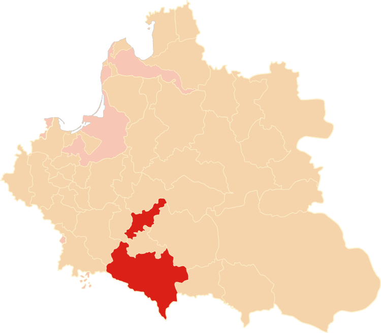
The Ruthenian Voivodeship or Russian Voivodeship (Latin: Palatinatus russiae, Polish: województwo ruskie, Ukrainian: Руське воєводство) was a voivodeship of the Crown of the Kingdom of Poland from 1434 until the 1772 First Partition of Poland. Together with a number of other voivodeships of southern and eastern part of the Kingdom of Poland, it formed Lesser Poland Province of the Polish Crown, with its capital city in Kraków. Following the Partitions of Poland, most of Ruthenian Voivodeship, except for its northeastern corner, was annexed by the Habsburg Empire, as part of the province of Galicia. Today, the former Ruthenian Voivodeship is divided between Poland and Ukraine.
Contents
History
Settled in prehistoric times, the central-eastern European land that is now the southeastern part of Poland and the western part of Ukraine was overrun in pre-Roman times by various tribes, including the Celts, Goths, and Vandals (Przeworsk culture). After the fall of the Western Roman Empire, the area was invaded by Hungarians, Slavs and Avars. The region subsequently became part of the Great Moravian state, and in the 10th century western part of future Russian Voivodeship became a site of contention between Poland, Kievan Rus and Hungary. In Kievan Rus' and Polish sources, western outskirts of the region was called Ziemia czerwieńska, or "Czerwień Land", from the name of Cherven, a town that existed there. Today there are several towns with this name, none of them related to Red Ruthenia.
This area was mentioned for the first time in 981, when Volodymyr the Great of Kievan Rus' took it over on the way into Poland. In 1018 it attached to Poland and 1031 back to Kievan Rus'. For approximately 150 years it existed as the independent Principality of Halych and Kingdom of Galicia–Volhynia (also known as the Kingdom of Rus'), before being conquered by Casimir III of Poland in 1349. Since these times the name Ruś Czerwona is recorded, translated as "Red Ruthenia" ("Czerwień" means red in Slavic languages, or from the Polish village Czermno), applied to a territory extended up to Dniester River, with priority gradually transferred to Przemyśl. Since the times of Władysław II Jagiełło, the Przemyśl voivodeship was called Ruthenian Voivodeship (województwo ruskie), with its center eventually transferred to Lwów. It consisted of five lands: Lwów, Sanok, Halicz, Przemyśl, and Chełm. The territory was controlled by the Austrian Empire from 1772 to 1918, when it was known as the Kingdom of Galicia and Lodomeria.
Zygmunt Gloger, in his monumental book Historical Geography of the Lands of Old Poland, provides this description of the Ruthenian Voivodeship:
In the 10th and 11th centuries, Przemysl and Czerwien were the largest gords in this region. Later on, Halych emerged as the capital of the province, while the city of Lwów was founded only in 1250. In ca. 1349, King Casimir III of Poland took control over Principality of Halych. The province was governed by royal starostas, the first one of whom was a man named Jasiek Tarnowski. Most probably in final years of reign of King Władysław II Jagiełło, it was named Russian Voivodeship, as at that time the voivodes of Przemysl began calling themselves the voivodes of Rus'. Firs such voivode was Jan Mezyk of Dabrowa.
Russian Voivodeship consisted of five ziemias: those of Lwów, Przemysl, Sanok, Halych and Chelm. The two last ones had their own local authorities; furthermore, the Land of Chelm was completely separated from other Ruthenian lands by the Belz Voivodeship. Therefore, we should speak separately of four Ruthenian lands, and the Land of Chelm, whose history was much different after the Partitions of Poland (...) The lands of Lwow, Przemysl and Sanok had their sejmiks, which took place in their respective capitals. General sejmiks for these three lands were at Sadowa Wisznia, where seven deputies were elected to the Polish Sejm: two from each land, and one from the County of Zydaczow. Starostas resided at Lwów, Zhydachiv, Przemysl and Sanok. The voivodeship had six senators: the Archbishop of Lwow, the Bishop of Przemysl, the Voivode of Ruthenia, the Castellan of Lwow, and Castellans of Przemysl and Sanok (...) The city of Lwów was the seat of a separate Lesser Poland Tribunal for the voivodeships of Ruthenia, Kijow, Volhynia, Podolia, Belz, Braclaw and Czernihow (...) The County of Zydaczow, even though officially part of Lwow Land, was often regarded as a separate ziemia, with its own coat of arms, granted in 1676. In that years, Lwow Land had 618 villages and 42 towns, while County of Zydaczow had 170 villages and 9 towns.
The Land of Przemysl was divided into two counties: those of Przemysl and Przeworsk. In 1676, the County of Przemysl had 657 villages and 18 towns, while the County of Przeworsk had 221 villages and 18 towns (...) The Land of Sanok, located in the Carpathian Foothills, was not divided into counties. In 1676, it had 371 villages and 12 towns (...)
The Land of Halicz, with its own separate local government, was divided into the counties of Trembowla, Halicz and Kolomyja. It had its own sejmik at Halicz, where six deputies were elected to the Polish Sejm (two from each county), also one deputy to the Crown Tribunal and one to the Treasury Tribunal at Radom. The Land of Halicz had one senator, and starostas, who resided in Halicz, Trembowla, Kolomuja, Tlumacz, Rohatyn, Jablonow, Sniatyn, Krasnopol, and other locations. In 1676, it had 565 villages and 38 towns.
The Land of Chelm was an enclave, separated from Ruthenian Voivodeship by Belz Voivodeship. The Bug river divided this land into two parts, and since the 10th century, Chelm was contested by Poland and Rus. In the course of the time, the Lithuanians also joined the conflict. It was ended in 1377, when King Louis annexed Chelm. The Land of Chelm had its own local offices, and a sejmik, where two deputies to the Sejm and one deputy to the Lesser Poland Tribunal were elected. It was divided into counties of Chelm and Krasnystaw, starostas resided in Chelm, Krasnystaw, Ratno, Luboml, Hrubieszow, and other locations. The Land of Chelm had two senators: the Bishop of Chelm and the Castellan of Chelm. In 1676, there were 427 villages and 23 towns in both counties (...) Southern part of the Land of Chelm belonged to the vast Zamoyski Family Fee Tail, which stretched beyond the region, into Urzedow County of Lublin Voivodeship.
Municipal government
Seat of the Voivodeship Governor (Wojewoda):
Regional Sejmik (sejmik generalny) for all Ruthene lands
Seats of Regional Sejmik (sejmik poselski i deputacki):