
Mouth River Avon, Warwickshire | Basin area 80 km² Country United Kingdom | |
 | ||
- location Upper Bruntingthorpe, Leicestershire | ||
The River Swift is a 14 mile (23 km) long tributary of the River Avon that rises in south Leicestershire, and flows through the town of Lutterworth before joining the Avon at its confluence in Warwickshire in the English Midlands.
Contents
Map of River Swift, United Kingdom
CourseEdit
The source of the river is a stream that rises near to Bruntingthorpe Aerodrome in Leicestershire, on the watershed division between the Avon and Soar catchments. The Swift passes the village of Walton and then Kimcote, where it meets a number of small streams that drain the headwaters of the catchment. The river continues in a south-westerly direction, passing to the north of Walcote then through the Misterton marshes Site of Special Scientific Interest, before reaching the M1 motorway bridge and the town of Lutterworth.
The river passes to the south of the town, where it is crossed by the Rugby road, near to the site of the ‘lost’ St Johns the Baptist hospital. After passing beneath the Lutterworth bypass, the Swift continues south-west until it reaches the Bransford Bridge crossing of the A5. This road follows the course of Watling Street, the Roman road that linked London to Wroxeter.
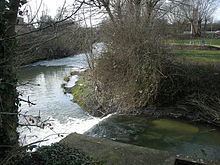
Downstream of the bridge the river passes the site of the deserted medieval village of Cestersover, and then the modern village of Churchover. At this point a canal feeder takes water from the river to supply the nearby canal. After passing beneath the M6 motorway, the river then flows directly south through the Swift Valley nature reserve, passes Brownsover Hall and then through the Swift industrial park. It is crossed by the Oxford canal in an aqueduct, and then passes through a retail park to join the River Avon, between Brownsover and Rugby.
CatchmentEdit
The Swift catchment lies between that of the Avon and Welland to the east, the River Sowe to the west, and the River Soar and its tributaries to the north, it covers an area of 80 square kilometres (31 sq mi).
In terms of geology of the catchment is underlain primarily by Lias Clay and mudstones, with an overlying layer of glacially deposited till, sands and gravels. This impermeable clay means that the Swift can become responsive in terms of runoff to heavy rainfall events.
FloodingEdit
The Swift has a minor history of flooding along its course, especially in Lutterworth, flood events being recorded in 1875, 1931 and most recently in 2008. A flood warning and alert service exists for the catchment, in conjunction with that for the Upper Avon and the Clay Coton brook.
In February 2012, a mother and her three children had to be rescued from their car when it was swept downstream from the ford between Churchover and Harborough Magna, after it had broken down in the floodwaters whilst crossing the river.