
- elevation 440 m (1,444 ft) - elevation 0 m (0 ft) | Discharge 15.89 m³/s Country United Kingdom Bridges Cowley Bridge | |
 | ||
Cities Exeter, Exmouth, Exminster, Exebridge, Exford, Thorverton, Stoodleigh, Rewe, Devon, Nether Exe, Exton, Somerset Similar | ||
River exe weirfields exeter devon
The River Exe (/ˈɛks/ EKS) in England rises at Exe Head, near the village of Simonsbath, on Exmoor in Somerset, 8.4 kilometres (5 mi) from the Bristol Channel coast, but flows more or less directly due south, so that most of its length lies in Devon. It flows for 60 miles (96 km) and reaches the sea at a substantial ria, the Exe Estuary, on the south (English Channel) coast of Devon. Historically, its lowest bridging point was at Exeter, though there is now a viaduct for the M5 motorway about 3 kilometres (2 mi) south of the city centre.
Contents
- River exe weirfields exeter devon
- Map of River Exe United Kingdom
- TopographyEdit
- 2008 cleansing operationEdit
- References
Map of River Exe, United Kingdom
TopographyEdit
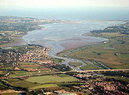
The river's name is an anglicisation of the Latin isca, itself a modified form of a Brittonic root meaning "water" or, more exactly, "abounding in fish". (The same root separately developed into the English Axe and Esk, the Welsh Usk, and the Scottish whisky.) It seems to be a cognate of pysg (pl. of pysgod), the Welsh word for 'fish'. The river gave the name of Exeter ("fortress on the Exe") and many other settlements along its course, including Exford, Up Exe, Nether Exe, Exwick, Exton, Exminster, and Exebridge, where it is joined by the River Barle. The seaside town of Exmouth is at the east side of the estuary mouth, and Dawlish Warren is at the west, with its long sand spit extending across the mouth.
The river fuelled Exeter's growth and relative importance in medieval times, and the city's first industrial area was developed at Exe Island, created by a series of leats to the west of the city. The island was home to numerous watermills producing paper and textiles; it also created valuable land through drainage of the marshlands.
Tides on the river are limited at Countess Wear, the site of a weir commissioned by the Countess of Devon in the 13th century. The Exeter Canal bypasses this weir to enable ships to reach Exeter Quay. At high tide, the estuary forms a large body of water that is heavily used for water sports especially sailing, windsurfing and water skiing.
Railways run along both sides of the estuary. The Avocet Line from Exeter to Exmouth on the eastern side, and the South Devon main line on the western. The latter is on a causeway, the South Devon Railway sea wall from Powderham to Dawlish Warren. The Exmouth to Starcross Ferry carries passengers across the mouth of the estuary during the summer months, linking the harbour at Exmouth with a pier adjacent to Starcross railway station on the South Devon main line.
At low tide, extensive mud flats are exposed, and these are an important feeding source for wading birds. Along with other rias in South West England, the Exe estuary is an important site for wintering waders. Dawlish Warren is a favoured site for birdwatching. The river has a low pH but does not suffer from a serious acid rain problem. It is populated with wild brown trout , and in the lower reaches coarse fish including dace, chub, perch, roach, pike and bream and some grayling, the average size being 8–10 ounces (230–280 g). There is a run of Atlantic salmon and a sparse run of sea trout. Just 150 metres (490 ft) below the union of the River Barle is Black Pool, which is one of the best, and highest salmon pools on the river. The smaller fish species present include stone loach and there are good reasons to assume others are present.
2008 cleansing operationEdit
In 2008 the Environment Agency embarked on a project to clean the river from vegetation forming. In order to do so the water level decreased to its lowest level – less water remained than the droughts the city has suffered.