
Length 19 km (11.8 mi) Coastline 63 km (39.1 mi) Elevation 1,721 m | Width 14 km (8.7 mi) Highest elevation 1,721 m (5,646 ft) Prefectures Hokkaidō Area 182.1 km² | |
 | ||
Points of interest Mount Rishiri, Senhoshimisaki Park, Himenuma, Rishirifuji Hot Spring, Rishirifureai Hot Spring Similar Rebun Island, Mount Rishiri, Cape Sōya, Okushiri Island, Noshappu Cape | ||
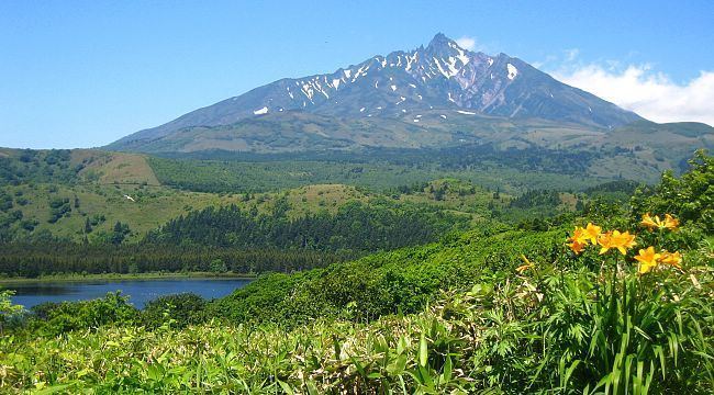
Rishiri Island (利尻島, Rishiri-tō) is an island in the Sea of Japan off the coast of Hokkaido, Japan. Administratively the island is part of Hokkaido Prefecture, and is divided between two towns, Rishiri and Rishirifuji. The island is formed by the cone-shaped extinct volcanic peak of Mount Rishiri. Along with Rebun Island and the coastal area of the Sarobetsu Plain, Rishiri forms the Rishiri-Rebun-Sarobetsu National Park. The main industries of Rishiri are tourism and fishing. The island is about 63 kilometres (39 mi) in circumference and covers 183 square kilometres (71 sq mi). The island has a population of 5,102 residents.
Contents
- Map of Rishiri Island Rishiri District Hokkaido Prefecture Japan
- Etymology
- Geography
- Communities
- Transportation
- History
- Economy
- Noted features
- References
Map of Rishiri Island, Rishiri District, Hokkaido Prefecture, Japan
Etymology
Rishiri derives its name from the Ainu language, and means "high island", or "island with a high peak", a reference to the altitude of Mount Rishiri above sea level.
Geography
Rishiri Island is located roughly 20 kilometres (12 mi) west of Hokkaido; Rebun Island is a further 10 kilometres (6.2 mi) to the northwest. Rishiri is roughly circular with a coastline of 63 kilometres (39 mi). The island spans 19 kilometres (12 mi) from north to south and 14 kilometres (8.7 mi) from east to west. Mount Rishiri rises to an altitude of 1,721 metres (5,646 ft) above the island. Mount Rishiri provides a good source of fresh water; numerous small ponds and springs are located at the foot of the mountain.
The residents of Rishiri Island live on the coastal areas of the island, which are connected by bus service which circumnavigates the island.
Communities
The island is divided between two towns, Rishiri (population, 2,304), which belongs to Rishiri District on south-west half of island, and Rishirifuji (population 2,798) on north-east half of island, both which belong to Rishiri District, Sōya Subprefecture.
These towns include the following communities, listed from the north side of the island, clockwise around:
Transportation
A bus runs the circuit route around the island.
Rishiri Airport is located in Rishirifuji.
History
Economy
The economy of Rishiri Island formerly depended on the fishing of Pacific herring, but the herring stock is now mostly depleted. Rishiri Island is now noted for its production of dried kombu.
Noted features
Other features of Rishiri Island include: