
Prominence 1,721 m (5,646 ft) Elevation 1,721 m Easiest route Hiking | Last eruption 5830 BC | |
 | ||
Topo map Geographical Survey Institute 25000:1 鴛泊25000:1 雄忠志内50000:1 Similar Mount Rausu, Mount Shari, Mount Tomuraushi, Mount Meakan, Mount Yōtei | ||
in hokkaido mount rishiri fuji 21 11 2014
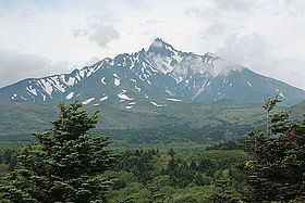
Mount Rishiri (利尻山, Rishiri-zan) is a quaternary stratovolcano located off the coast of Hokkaidō, Japan in the Sea of Japan. The extinct volcano rises out of the sea forming Rishiri Island. Because its cone shape resembles Mount Fuji it is sometimes referred to as Rishiri Fuji. It is one of the 100 famous mountains in Japan.
Contents
- in hokkaido mount rishiri fuji 21 11 2014
- Map of Mount Rishiri Kutsugata Rishiri Rishiri District Hokkaido Prefecture 097 0401 Japan
- Geology
- Climbing route
- In popular culture
- References
Map of Mount Rishiri, Kutsugata, Rishiri, Rishiri District, Hokkaido Prefecture 097-0401, Japan
Mount Rishiri's opening festival is held annually on July 2 and July 3. This festival officially opens the climbing season.
Geology
Mount Rishiri is made up of alkali and non-alkali mafic volcanic rock dating from the Late Pleistocene, 130,000–18,000 years ago. Otherwise it is covered in quaternary volcanic rock debris.
Climbing route
The ascent of Rishiri is suitable for novice hikers, but can be challenging in places. There is a campsite partway up the mountain from the dock, and an unmanned hut located a short distance below the summit. There is also a small shrine at the summit. On clear days the view extends to Hokkaidō, the adjacent island of Rebun, and as far as Sakhalin Island in Russia.
In popular culture
The package of Shiroi Koibito includes a picture of Mount Rishiri arranged in the centre.