
Length 61.6 km | Counties: Washington | |
 | ||
County | ||
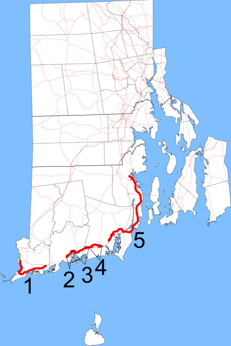
Route 1A is a 39.6-mile (63.7 km) long numbered state highway located in Washington County, Rhode Island, United States. The route, which parallels U.S. Route 1 for its entire length, has five distinct sections, each separated by short overlaps with US 1.
Contents
- Map of RI 1A Rhode Island USA
- Westerly to South Kingstown
- Wakefield to Wickford
- History
- Major intersections
- References
Map of RI-1A, Rhode Island, USA
Westerly to South Kingstown
Route 1A follows U.S. Route 1 (US 1) closely through Washington County, locally known as "South County." US 1 is a divided highway for most of its length in this region; there is also a short freeway section in South Kingstown and Narragansett. Because Interstate 95 largely bypasses the main population centers in the southern portion of the state, instead following a more inland routing, US 1 serves as the main thoroughfare. Route 1A, in comparison, runs on surface streets, acting as an alternate route for US 1 that provides access to more local roads and business districts. There are five distinct sections, each separated by short concurrencies with US 1; as an alternate route, Route 1A is unsigned on each concurrency.
The first section of Route 1A is 8.8 miles (14.2 km) in length and runs entirely in Westerly. Beginning in downtown Westerly, the roadway takes a more southerly routing in the town than its parent route and serves the affluent coastal community of Watch Hill and Misquamicut State Beach. In Westerly, Route 1A north actually follows a due south route for its first 3.7 miles (6.0 km). The roadway begins as Main Street, which merges with US 1 (Broad Street) just after the latter route crosses the Pawcatuck River from Stonington, Connecticut into downtown Westerly. Route 1A north continues southward on Beach Street before turning south onto Watch Hill Road. The roadway then turns to the southeast along Shore Road, which runs parallel to Misquamicut Beach, Atlantic Beach and Winnapaug Pond, until Shore Road meets Post Road not far from the Charlestown town line. Many maps incorrectly post the entire length of Watch Hill Road west of Shore Road as Route 1A.
After Shore Road merges with Post Road, Route 1A has an 4.1-mile (6.6 km) unsigned concurrency with US 1 in Westerly and Charlestown. Just after Post Road, carrying both US 1 and unsigned Route 1A, passes into Charlestown, the road intersects with Route 216 (Ross Hill Road). Route 216 ends at this intersection. The second signed section of Route 1A, which is 1.4 miles (2 km) in length, begins shortly after Post Road passes Ninigret Pond. The roadway follows Old Post Road in Charlestown past Ninigret State Park before briefly merging back with US 1 (Post Road).
The second US 1/Route 1A concurrency is only 0.1 miles (0.16 km) long. The third signed section of Route 1A, which is 3.1 miles (5.0 km) in length, again follows Old Post Road through Charlestown and into South Kingstown before re-merging with US 1. It serves as a beach bypass, granting access to the roads to Charlestown Breachway State Beach, Charlestown Town Beach and Green Hill Beach.
The third US 1/Route 1A concurrency is 0.8 miles (1.3 km) in length, including the distance of a median turnaround required to reverse direction on US 1; Route 1A north automatically merges onto US 1 north, but to continue to follow Route 1A north, drivers must make a U-turn onto US 1 south. The fourth section of Route 1A (2.1 miles (3.4 km) in length) follows Post Road, which exits from US 1 south and follows a more northerly routing than that of its parent highway. The route, while bypassing the busier US 1, is little more than a residential road. Just before merging with US 1, Route 1A intersects Route 110 (Ministerial Road). Route 110 ends just 0.25 miles (0.40 km) south of this intersection at a merge with US 1. At the end of Route 1A's fourth segment, the roadway merges onto US 1 south; in order to access US 1 north (and unsigned Route 1A north), drivers must utilize another median turnaround.
Wakefield to Wickford
After the fourth section, Route 1A is concurrent with US 1 for 2.0 miles (3.2 km) through South Kingstown. Just after the highway passes by the access road to Jerusalem, a small fishing village, Route 1A unofficially leaves US 1 and re-emerges as Post Road, beginning its fifth signed segment. This fifth segment runs for 17.2 miles (27.7 km) and serves as a major commercial corridor for the towns of South Kinsgtown, Narragansett, and North Kingstown. After splitting from US 1, Route 1A runs for 1.2 miles (1.9 km) before intersecting with its parent highway again; drivers must merge onto US 1 northbound and quickly make a median U-turn to continue to follow Route 1A, as there is no grade-separated interchange at this junction. Route 1A then runs north and east along Post Road and Main Street into the village of Wakefield, a major commercial center of South Kingstown. Just after exiting downtown Wakefield, the road intersects with Route 108, beginning a 0.7-mile (1.1 km) wrong-way concurrency: Route 1A north and Route 108 south run in a southeasterly direction along Kingstown Road. After entering the town of Narragansett, the concurrent routes partially intersect US 1 at a grade-separated interchange. Just south of the US 1 overpass, Route 108 south and Route 1A north both enter the Dillon (Narragansett) Rotary. Route 108 exits to the south, heading towards the villages of Galilee and Point Judith, while Route 1A exits to the east, heading towards the village of Narragansett Pier.
The 4.4-mile (7.1 km) portion of Route 1A in Wakefield between US 1 and the Dillon Rotary is not actually signed as part of Route 1A on most maps; however, the Rhode Island Department of Transportation (RIDOT) has posted reassurance markers on Post Road, Main Street and Kingstown Road though Wakefield, and the register of state highways indicates that this routing is officially part of Route 1A.
In Narragansett, Route 1A follows Kingstown Road and Narragansett Avenue. When the highway reaches the village of Narragansett Pier, it turns due north onto Beach Street and passes Narragansett Town Beach just north of The Towers. The mainline of Beach Street becomes Boston Neck Road just north of the village center and crosses the Pettaquamscutt River (also known as Narrow River) via the Sprague Bridge. Route 1A serves as a major commercial corridor in northern Narragansett, and also provides access to the village of Bonnet Shores. It then crosses into the Saunderstown neighborhood of North Kingstown, interchanging with Rhode Island Route 138 just west of the Jamestown-Verrazano Bridge. Route 1A heads north for another 3.3 miles (5.3 km) before crossing a branch of Wickford Cove via the Hussey Bridge, entering the village of Wickford. Route 1A turns north onto Brown Street, intersecting with the southern terminus of Route 102. The roadway then turns to the west onto West Main Street before terminating at US 1 just northwest of the main Wickford business district.
History
At various points in time, every segment of Route 1A except the one in Westerly served as part of U.S. 1 (historically the Lower Boston Post Road). The Route 1A designation came after the U.S. 1 designation was moved to a different alignment.
Before that, Route 1A existed on an alignment that is now roughly Route 3.
The 19.0-mile (30.6 km) piece from old U.S. 1 in downtown Wakefield to current US 1 near Wickford, now most of section 5 above, was once Route 1B. It was renumbered to Route 1A by 1934.
Major intersections
The entire route is in Washington County.