
Basin countries United States Surface elevation 0 cm Length 6.29 km Width 2.95 km | Max. length 3.91 mi (6.29 km) Area 6.396 km² Mean depth 1.31 m | |
 | ||
Primary inflows Catchment area 7,645.65 acres (30.9408 km) Similar Ninigret National Wildlife R, East Beach State Beach, Fort Ninigret, Quonnie Beach, Point Judith Pond | ||
2012 ninigret pond worm hatch
Ninigret is a coastal lagoon in Charlestown, Rhode Island, in the United States, located at 41°22′45″N 71°38′43″W. It is the largest of the nine lagoons, or "salt ponds", in southern Rhode Island. It is utilized for recreational actives, as well as oyster and quahog harvesting. Found along its shores are "extensive" archaeological remains. Ninigret Pond, like others in the region, was "formed after the recession of the glaciers 12,000 years ago". The pond is situated on low-lying ground, and as such, it is considered particularly vulnerable to storm surge flooding. It is connected to Green Hill Pond via a small channel.
Contents
- 2012 ninigret pond worm hatch
- Map of Ninigret Pond Charlestown RI 02813 USA
- Ninigret pond ri breachway
- Watershed and restorationEdit
- References
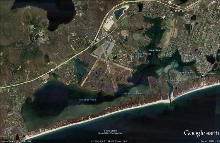
Map of Ninigret Pond, Charlestown, RI 02813, USA
The pond is located within the Ninigret National Wildlife Refuge. Both are named for Ninigret, a 17th-century sachem of the eastern Niantic aboriginal American tribe.
Ninigret pond ri breachway
Watershed and restorationEdit
According to information compiled by the Rhode Island Sea Grant program, Ninigret Pond's watershed covers 7,645.65 acres (3,094.08 ha), of which 5,820.79 acres (2,355.59 ha) is occupied by water; Ninigret Pond itself has a surface area of 1,580.38 acres (639.56 ha), while other, smaller bodies of water account for the other 244.48 acres (98.94 ha). Averaging 4.3 ft (1.3 m) deep, Ninigret Pond has a salinity level of 24 parts per thousand. The pond receives: about 1,927,399,642 gallons of precipitation per year; 8,974,614–12,376,282 gallons of groundwater flow per day; and 1,881,774–4,849,186 of river and stream flow per day. It is permanently connected to the Block Island Sound by a constructed breachway.
As a result of heavy development along the eastern shore, there are indications that water quality is degrading; however, restoration efforts are in place. Eelgrass population has also been significantly declining. Dredging and cleanup projects have additionally been established. In the past, breakwaters were established, allowing an inflows of sand to "choke" the pond. The Coastal Resources Management Council and the Army Corps of Engineers spent in excess of $4.1 million to remove harmful sand accumulations. Despite this, Ninigret was assessed as being the cleanest of the nine salt ponds. In contrast, Winnapaug Pond contains high levels of pollution. During the 1960s, Ninigret Pond was included as part of one of the first "integrated multidisciplinary studies of a coastal marine ecosystem".