
- left Lô Length 1,149 km | - right Đà Source elevation 1,776 m Mouth elevation 0 | |
 | ||
- location (boundary between Tiền Hải and Giao Thủy) - average 2,640 m/s (93,231 cu ft/s) Bridges Long Biên Bridge, Nhật Tân Bridge, Chương Dương Bridge | ||
The Red River (simplified Chinese: 红河; traditional Chinese: 紅河; pinyin: Hóng Hé; Vietnamese: Sông Hồng), also known as the Hồng Hà and Sông Cái ( "Mother River") in Vietnamese and the Yuan River (元江, Yuán Jiāng) in Chinese, is a river that flows from Yunnan in Southwest China through northern Vietnam to the Gulf of Tonkin. According to C. Michael Hogan, the associated Red River Fault was instrumental in forming the entire South China Sea at least as early as 37 million years before present.
Contents
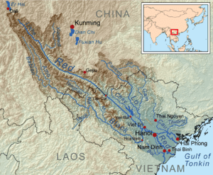
Map of Red River
Geography
The Red River begins in China's Yunnan province in the mountains south of Dali. It flows generally southeastward, passing through Dai ethnic minority areas before leaving China through Yunnan's Honghe Autonomous Prefecture. It enters Vietnam at Lào Cai Province. It forms a portion of the international border between China and Vietnam. The river, known as Thao River for this upper stretch, continues its southeasterly course through northwestern Vietnam before emerging from the mountains to reach the midlands. Its main tributaries, the Black River (Da River) and Lô River join in to form the very broad Hồng near Việt Trì, Phu Tho Province. Downstream from Việt Trì, the river and its many distributaries spread out to form the Red River Delta. The Red River flows past the Vietnamese capital Hanoi before emptying into the Gulf of Tonkin.
The reddish-brown heavily silt-laden water gives the river its name. The red river has a reddish-brown tint to the river because of the silt. The Red River is notorious for its violent floods with its seasonally wide volume fluctuations. The delta is a major agricultural area of Vietnam with vast area devoted to rice. The land is protected by an elaborate network of dikes and levees.
The Black River and Lô River are the Red River's two chief tributaries.
As a travel and transportation route
In the 19th century, the Red River was thought to be a lucrative trade route to China. The late 19th-century French explorers were able to travel up the Red River until Manhao in South Yunnan, and then overland toward Kunming.
The Red River remained the main commercial travel route between the French Indochina and Yunnan until the opening of the Kunming–Hai Phong Railway in 1910. Thanks to the river, Hai Phong was in the early 20th century the sea port most easily accessible from Kunming. Still, the travel time between Hai Phong and Kunming was reckoned by the Western authorities at 28 days: it involved 16 days of travel by steamer and then a small boat up the Red River to Manhao (425 miles), and then 12 days overland (194 miles) to Kunming.