
Topo map Ratón CSRHP # 5LA.2182 Area 6.151 km² Added to NRHP 15 October 1966 | NRHP Reference # 66000474 Elevation 2,388 m Year built 1866 | |
 | ||
Nearest city Trinidad, CO, Raton, NM Range Sangre de Cristo Mountains, Rocky Mountains Similar Tennessee Pass (Colorado), La Veta Pass, Sangre de Cristo Mountains | ||
Colorado to new mexico on raton pass
Ratón Pass (7834 feet or 2388 meters elevation) is a mountain pass on the Santa Fe Trail along the Colorado-New Mexico border in the United States. Raton Pass is a federally designated National Historic Landmark. Ratón is Spanish for "mouse."
Contents
- Colorado to new mexico on raton pass
- Map of Raton Pass New Mexico 87740 USA
- Snowing at raton pass 4 30 16
- HistoryEdit
- Railroad RouteEdit
- In Popular CultureEdit
- References
Map of Raton Pass, New Mexico 87740, USA
The pass is located on the eastern side of the Sangre de Cristo Mountains between Trinidad, Colorado and Raton, New Mexico, approximately 100 miles (160 km) northeast of Santa Fe. The pass crosses the line of volcanic mesas that extends east from the Sangre de Cristo Mountains along the state line, and furnishes the most direct land route between the valley of the Arkansas River to the north and the upper valley of the Canadian River, leading to Santa Fe, to the south.
Snowing at raton pass 4 30 16
HistoryEdit
In 1821, Captain William Becknell laid the path of the Santa Fe Trail through the pass. In 1846 during the Mexican–American War, Stephen W. Kearny and his troops passed through the pass en route to New Mexico. During the Civil War, it was the primary path into New Mexico since it avoided Confederate raiders. It was later developed into a toll road by Richens Lacey Wootton.
In the 20th century the Pass became the route of U.S. Route 85 and later Interstate 25 between Denver and Albuquerque. The road at the pass is at an elevation of 7834 feet above sea level, and therefore is subject to difficult driving during heavy winter snowfalls
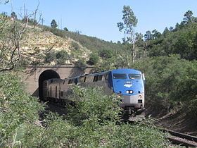
Railroad RouteEdit
In the late 19th century, it was used by the Atchison, Topeka and Santa Fe Railway as the railroad's primary route through the mountains. Along with the Royal Gorge in Colorado the pass was one of the focal points for the 1878-1879 Railroad Wars between the AT&SF and the smaller Denver and Rio Grande Railroad. The route over the pass required gradients of up to 3.5%, with a tunnel at the highest point of the AT&SF, at 7588 feet above sea level. The tunnel is entirely within New Mexico, with its northern portal only a few feet south of the Colorado border.
BNSF, which absorbed the Santa Fe railroad in 1996, and Amtrak continue to use this route. However, following completion of the Belen Cutoff in 1908, the majority of freight traffic was diverted over the Cutoff, which has gradients of no more than 1.25%. Amtrak's Southwest Chief passenger service between Chicago and Los Angeles, continues to use Raton Pass (one train daily in each direction). In 2012, there was not enough freight traffic for BNSF to maintain the line up to the standards required by Amtrak for continued intercity service. This problem has placed the future of rail transportation over Raton Pass in jeopardy.
In Popular CultureEdit
The pass was part of a Townes Van Zandt song "Snowin' on Raton". During a live performance, Townes commented how he liked playing a show in Colorado because he didn't have to explain what Raton was. It was declared a National Historic Landmark in 1960.
Raton Pass is mentioned in C.W. McCall's (Bill Fries) song "Four Wheel Cowboy", from his album Wilderness. "Four Wheel Cowboy" also appears on his compilation release titled; The Best of C.W. McCall.
Clint Black makes reference to the Raton Pass in the song "The Goodnight-Loving" from the album "Put Yourself in My Shoes."
Ridin' against the wind in east New Mexico.His skin is dry and worn as the Texas plains.He's headed where the air is thin and the cold blue northers blow.Up through the Raton Pass but he'll have to beat the early snow