Area 449.7 km² Local time Saturday 2:00 AM | Population 4,893 (30 Sep 2016) | |
 | ||
Time zone Japan Standard Time (UTC+9) Weather 0°C, Wind NW at 21 km/h, 77% Humidity Points of interest Kogane Hot Spring, Mount Mekunnai, Mount Raiden | ||
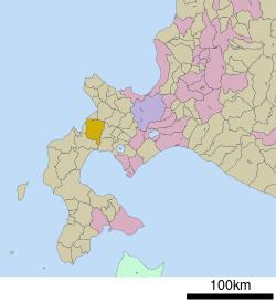
Rankoshi (蘭越町, Rankoshi-chō) is a town located in Isoya District, Shiribeshi Subprefecture, Hokkaido, Japan.
Contents
- Map of Rankoshi Isoya District Hokkaido Prefecture Japan
- Geography
- Neighboring towns
- History
- Education
- Transportation
- Sister city
- References
Map of Rankoshi, Isoya District, Hokkaido Prefecture, Japan
As of 2016, the town has an estimated population of 4,893 and a density of 11 persons per km². The total area is 449.68 km².
Geography
Shiribetsu River flows through Rankoshi to the Sea of Japan. The town is surrounded by Niseko Volcanic Group, which belongs to Niseko-Shakotan-Otaru Kaigan Quasi-National Park.
The name is derived from Ainu word "ranko-usi", meaning "Place with many Katsura trees".
Neighboring towns
History
Education
Transportation
Sister city
References
Rankoshi, Hokkaido Wikipedia(Text) CC BY-SA
