Area 345.6 km² Local time Sunday 2:21 PM | Website www.kuromatsunai.com Population 2,983 (30 Sep 2016) | |
 | ||
Time zone Japan Standard Time (UTC+9) Weather 5°C, Wind NW at 21 km/h, 68% Humidity | ||
Kuromatsunai (黒松内町, Kuromatsunai-chō) is a town located in Suttsu District, Shiribeshi, Hokkaido, Japan.
Contents
- Map of Kuromatsunai Suttsu District Hokkaido Prefecture Japan
- Geography
- Neighboring towns and village
- History
- Transportation
- Sister city
- Education
- References
Map of Kuromatsunai, Suttsu District, Hokkaido Prefecture, Japan
As of 30 September 2016 the town had an estimated population of 2,983 and a density of 8.6 persons per km². The total area of the town is 345.65 km².
Geography
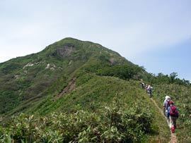
Kuromatsunai is located in the southern part of Shiribeshi Subprefecture and while close to both the Sea of Japan and the Pacific Ocean the town itself has no coastline. The Shubetsu River flows through Kuromatsunai.
The town, being the northernmost area of Japan in which beech trees grow naturally, has designated the beech a natural treasure.
Neighboring towns and village
History
Transportation
Sister city
Education
References
Kuromatsunai, Hokkaido Wikipedia(Text) CC BY-SA
