
- left North Raisin River - elevation 96 m (315 ft) Discharge 5.09 m³/s Basin area 57.98 km² | - right South Raisin River - elevation 43 m (141 ft) Basin area 57.98 km² | |
 | ||
- location Newington, South Stormont - location Lancaster, South Glengarry | ||
The Raisin River is a river in South Stormont and South Glengarry, United Counties of Stormont, Dundas and Glengarry in eastern Ontario, Canada, with the watershed encompassing portions of North Stormont, North Glengarry and the city of Cornwall as well. It empties into Lake Saint Francis on the Saint Lawrence River near the community of Lancaster.
Contents
The river's name is an anglicised form of the earlier French settler name "la rivière aux Raisins", which referred to the wild grapes (raisins in French) that can still be found growing along the shores of the river.
CourseEdit
The river begins in a field about 2 kilometres (1.2 mi) west of the community of Newington. It travels south to the community of Bunker Hill, then turns east, and takes in the left tributaries Palen Creek, Shaver Drain and Wereley Creek near the community of North Lunenburg. The Raisin River continues east, takes in the left tributary Stoney Creek at the community of Black River, and passes under Ontario Highway 138 at the community of St. Andrews. It heads northeast, takes in the left tributary Beaver Creek and right tributary McIntosh Drain, then the left tributary North Raisin River at the community of Martintown. It heads east, passes into South Glengarry, takes in the right tributary Glen Falloch Drain and left tributary McIntyre Creek, then reaches the community of Williamstown and the right tributary South Raisin River. The river continues east, takes in the right tributary Glen Drain, passes under Ontario Highway 401, and reaches Lake Saint Francis.
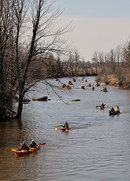
RecreationEdit
The "Great Raisin Raisin River Foot Race" is held in Williamstown. In spring, the "Raisin River Canoe Race" runs from Saint Andrews to Williamstown.