UN Map - Tanga and Kidatu lines not shown.Railways in southern AfricaOfficial mapUNHCR MapInteractive map of Tanzania railwaysLook for the MSN Map at the bottom of pages of many towns, or look for the Map Button at the top and scroll down the MSN map.( all 1,000 mm (3 ft 3 3⁄8 in) gauge)
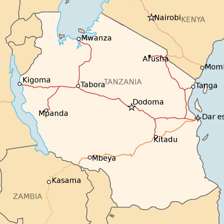
Dar es Salaam - ocean port - former national capital - 8 km from TAZARA line Ruvu (75m) - junction to Tanga lineMorogoro (510m) - junction to northKilosa (572m) - junction going south to TAZARAGulwe (680m)Igandu (985m)Dodoma (1148m) - national capitalManyoni (1244m) - junction going north to SingidaItigi (1306m)Ikungu (1289m)Tabora (1212m) - junction going north to MwanzaKaliua (1112m) - junction going south to MpandaKigoma (775m) - terminal and port on Lake Tanganyika(Not shown on map)Kilosa (572m) - junctionKidatu (294m) - branch terminus - also served with break of gauge by TAZARA, with a container trans-shipment facility to move freight containers between TAZARA and Tanzania Railways Corporation trainsTabora (1212m) - junctionBukene (1188m)Isaka (1197m) - 'dry port' and proposed junction for lines to Rwanda and BurundiShinyanga (1126m)Mwanza (1209m) - inland port on Lake VictoriaMpanda Line
Kaliua (1112m) - junctionMpanda (1074m) - branch terminusManyoni (1244m) - junctionIssuna (1423m)Ikungi (1532m)PumaSingida (1122m) - branch terminusMorogoro (510m) - junction with Central LineRuvu (75m)Kitonga (65m)Sadani (1m)Hale (184m) - junctionKorogwe (301m) - junction with Tanga LineTanga (1m) - ocean portKorogwe (301m) - junction to southMkomazi (485m)Same (897m)Moshi (990m) - junction to north and KenyaArusha (1254m) - soda ash miningSeptember 2007Arusha (1254m)Musoma (1172m) on Lake Victoria.TangaMwambani Bay(1,435 mm (4 ft 8 1⁄2 in) gauge)TangaSingida Mutukula, Tanzania Mutukula, UgandaKampala(branch)MutukulaMusoma - Lake Victoria portIn 1949 a line was built to link the Tanganyika groundnut scheme plantations around Nachingwea with the port of Mtwara. The scheme famously foundered and the railway was abandoned in 1962. Proposals have been made for a new railway to link Mtwara to iron ore deposits in the west, perhaps linking via Songea to Liganga.
Island of Unguja
A short 610 mm (2 ft) line lasted from 1879 to 1888.
Mtwara (1 m) - port for groundnut schemeLindi (1 m) - potential port Nachingwea (380 m) groundnut scheme terminusMchuchuma (____m) - coalSongeaLiganga (1210 m) - iron oreFormerly also called TanZam Railway.
1,067 mm (3 ft 6 in) gauge to match Zambian/Southern African networks.
Dar es Salaam - ocean port - 8 km from TRC line Mzenga (137 m)Kisaki (292 m)Kidatu (294 m) - break of gauge connection with Tanzania Railways Corporation, with a container trans-shipment facility to move freight containers between TAZARA and Tanzania Railways Corporation trains. on short branch.KiberegeIfakara (192 m)MakumbakoChimpalaMbeya (1661 m) - workshopsMboziVwawa (1274 m) Tunduma, Tanzania (1301 m) - Tanzania / Zambian border Mkushi, Zambia (1277 m)Mbeya possible junctionKasanga North-South Corridor Project 1,000 mm (3 ft 3 3⁄8 in) and 1,067 mm (3 ft 6 in) are too close to allow 3-rail dual gauge; you have to have 4-rail dual gauge. But if you have 4-rail gauge, then you can include 1,435 mm (4 ft 8 1⁄2 in) gauge (standard gauge) at the cost of slightly longer sleepers.
The container port at Dar es Salaam is served by both 1,000 mm (3 ft 3 3⁄8 in) and 1,067 mm (3 ft 6 in) gauge tracks.