
 | ||
Presidential traverse go pro 1080p
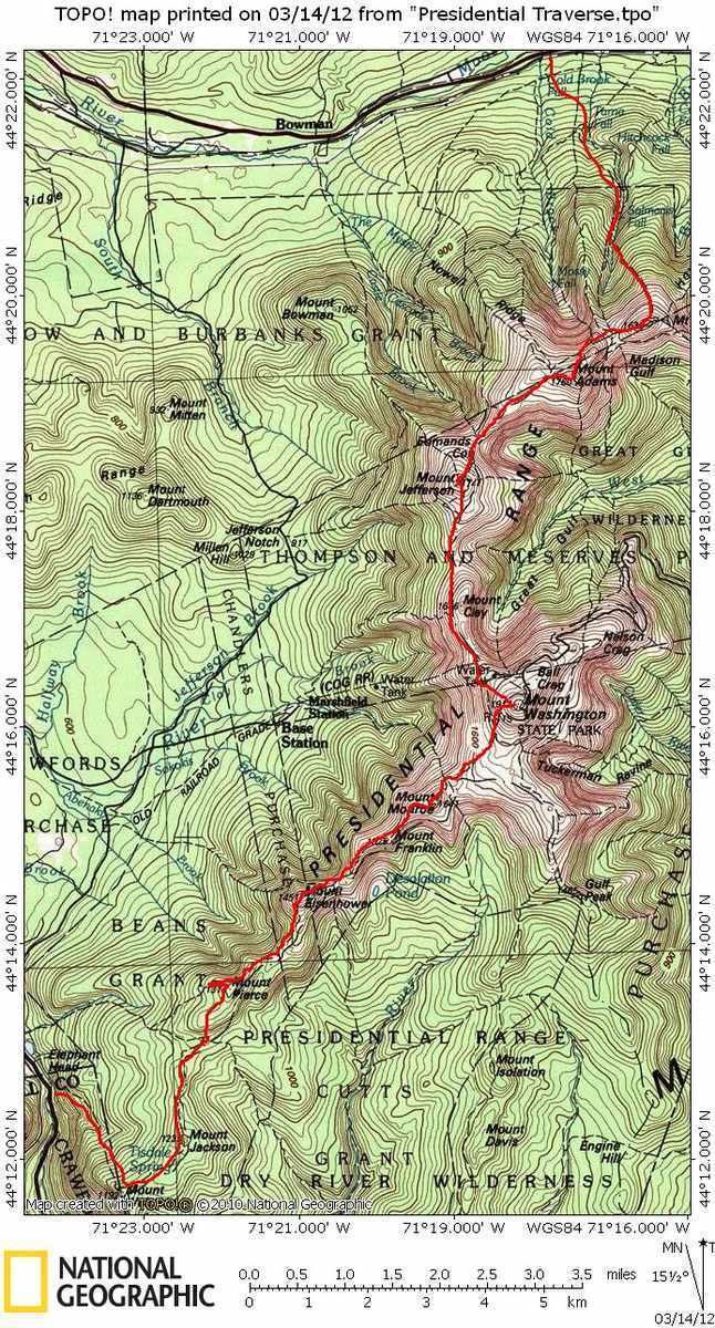
A Presidential Traverse is a strenuous and sometimes dangerous trek over the Presidential Range of New Hampshire's White Mountains. Contained almost entirely in the 750,000-acre (3,000 km2) White Mountain National Forest, the Presidential Range is a string of summits in excess of 4,000 feet (1,200 m). To complete the traverse, one must begin at either the northern or southern terminus of the Presidential Range and finish at the opposing end. Beginning the journey at the northern end at Mount Madison, one would pass through the townships of (in order, going in a generally south-southwesterly direction) Low and Burbank's Grant, Thompson and Meserve's Purchase, Sargent's Purchase, Chandler's Purchase, and Bean's Purchase (at Mount Pierce), all of which are in Coös County.
Contents
- Presidential traverse go pro 1080p
- Hiking the presidential traverse in new hampshire s white mountains
- The minimum
- Additional named peaks
- Sub peaks
- Hazards
- Weather
- Winter
- Vertical
- References
Hiking the presidential traverse in new hampshire s white mountains
The minimum
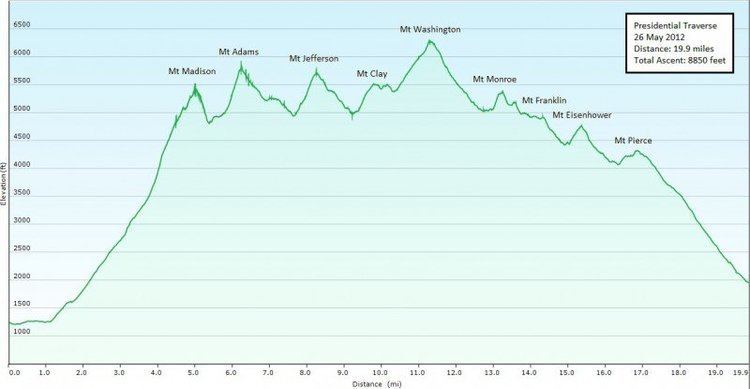
The basic Presidential Traverse begins from a trailhead on U.S. Route 2 or at the Dolly Copp Campground at the northern end of the Presidentials, crosses the great ridge of the range and ends in Crawford Notch at its southern terminus, or vice versa. A hiker making such a journey would travel about 23 miles (37 km), with 9,000 feet (2,700 m) of elevation gain.
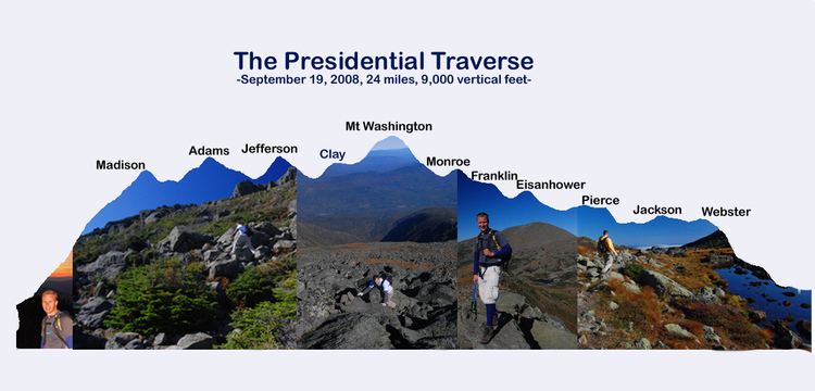
By definition, a "presidential" traverse requires a participant to cross over the summits of peaks named after U.S. presidents. Listed from north to south, they are:
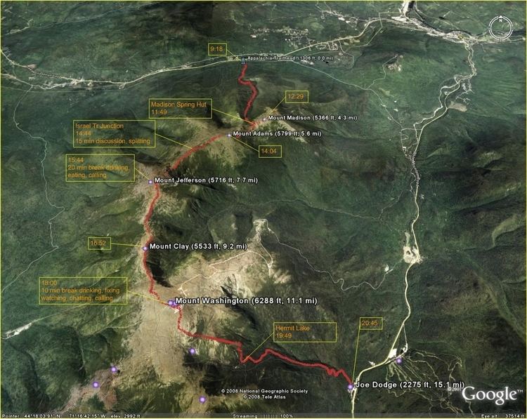
The total distance could be shortened to 19.2 miles (30.9 km) by only taking standard through trails. However, you would not summit all peaks.
Additional named peaks
A traverse which collects all of the trail-accessible peaks in the Presidential Range includes (from north to south):
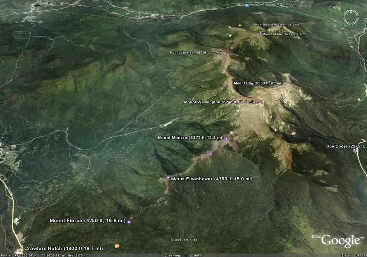
Adding these peaks increases total mileage traveled and elevation gain to 22.8 miles (36.7 km) and 10,041 feet (3,060 m).
Sub-peaks
Several minor peaks ineligible for the list due to lack of prominence have no maintained trails leading to their summits. However, hikers with solid outdoor orientation skills may bushwhack them as part of a traverse. These include:
Hazards
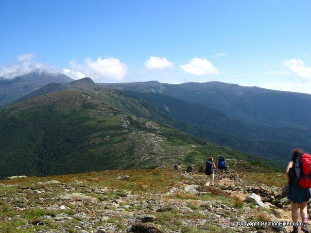
The White Mountains and the Presidential Range in particular offer both some of the most beautiful vistas in the Eastern United States and some of its most challenging and dangerous terrain. Many hikers attempting a Presidential Traverse have become lost or otherwise disabled in inclement weather above treeline, causing many costly search and rescue operations.
Weather
The Presidential Range is perhaps most famous for its tumultuous weather, highlighted by the erratic and often extreme conditions upon Mount Washington. Being both at the intersection of several storm tracks and the center of multiple converging valleys funneling wind from the west, southwest, and south make its weather unpredictable and at times violent. The summit of Mount Washington has been known to see snow and ice in all seasons and is subject to a combination of hurricane force winds and blanketing clouds an average of 110 days a year. The mountain long held the record for the highest wind speed ever recorded at the Earth's surface, clocking 231 miles per hour (372 km/h), forcing summit buildings to be chained down so they won't blow away.
Winter
Views from the Presidentials ridgeline in the crisp winter air are unrivaled in the Northeast. However, winter terrain is more treacherous, temperatures may plummet with dangerous speed, and winds often hit triple digits. Snowfall at elevation is measured in feet instead of inches, avalanches are common on the large snowfields and in ravines, and blowing snow, ice fog, and heavy clouds can cause visibility to disappear in minutes. Consequently, those wishing to tackle a Presidential Traverse in winter must be exceptionally fit, experienced in winter mountaineering and compass orientation techniques, very familiar with the terrain, and have high quality winter gear. Lacking any one of these puts one in serious peril of requiring expensive and hazardous rescue, even death.
Vertical
A Presidential Traverse does not merely require the absolute gain of some 4,500' from starting point to the 6,288' summit of Mt. Washington; it involves repeated gain and loss of elevation between individual summits along the way. The fact that the range stretches less than twenty miles from one end to the other and most of its main trails are easily accessible from major through roads errantly suggests that the terrain embraced by the Presidentials lacks remoteness. In truth, the range is a wind ravaged wilderness. A basic Presidential Traverse encompasses almost 9,000' of combined vertical, doubled when difficult downclimbing is included. Adding the principal sub-peaks stretches this to almost 20,000' of up- and downclimb in a single traverse.