
 | ||
Postal codes used in the United Kingdom are known as postcodes (originally postal codes). They are alphanumeric and were adopted nationally between 11 October 1959 and 1974, having been devised by the GPO (Royal Mail). A full postcode is known as a "postcode unit" and designates an area with a number of addresses or a single major delivery point.
Contents
- London
- Other large towns
- Modern postcode system
- Adaptation of earlier systems into national system
- GB postcodes available as OpenData
- Postcodes linked to a variety of UK geographies
- Overview
- Outward code
- Inward code
- Postcode area
- Postcode district
- Postcode sector
- Postcode unit
- Validation
- Post towns
- Crown dependencies
- Overseas territories
- British Forces Post Office BFPO
- Non geographic codes
- Special postcodes
- ZZ99
- Sorting
- Integrated Mail Processors
- Mailsort and Walksort
- Listings and availability
- Life cycle of post codes
- Postcode Address File PAF
- Code Point Open
- ONS Postcode Directory
- Other uses
- References
Postcodes have been adopted for a wide range of purposes in addition to aiding the sorting of the mail: for calculating insurance premiums, designating destinations in route planning software and as the lowest level of aggregation in census enumeration. The boundaries of each postcode unit and within these the full address data of currently about 29 million addresses (delivery points) are stored, maintained and periodically updated in the Postcode Address File database.
The initial system of named postal districts, developed in London and other large cities from 1857, evolved towards the present form: in 1917 London was split into broad numbered subdivisions, and this extended to the other cities in 1934.
The structure of a postcode is a one or two-letter postcode area code named for a local town or area of London, one or two digits signifying a district in that region, a space, and then an arbitrary code of one number and two letters. For example, the postcode of the University of Roehampton in London is SW15 5PU, where SW stands for south-west London. The postcode of GCHQ is GL51 0EX, where GL signifies the postal town of Gloucester. The postal town refers to a wide area and does not relate to a specific town, county or region. GL51 is one of the postcodes for the town of Cheltenham (in Gloucestershire) which is where GCHQ is located.
London
The London post town covers 40% of Greater London. On inception (in 1857/8) it was divided into ten postal districts: EC (East Central), WC (West Central), N, NE, E, SE, S, SW, W, and NW. The S and NE sectors were later abolished. In 1917, as a wartime measure to improve efficiency, these were subdivided with a number applied to each sub-district, with the area served directly by the district head office as "1" with the others allocated alphabetically by delivery office, leading to N2 East Finchley delivery office, N3 Finchley delivery office, N4 Finsbury Park delivery office. These divisions changed little, usually only changed for operational efficiency.
Some older road signs in Hackney still indicate the North East (NE/N.E.) sector/district.
Other large towns
Following the successful introduction of postal districts in London, the system was extended to other large towns and cities. Liverpool was divided into Eastern, Northern, Southern and Western districts in 1864/65, and Manchester and Salford into eight numbered districts in 1867/68.
In 1917 Dublin – then still part of the United Kingdom – was divided into numbered postal districts. These continue in use in a modified form by An Post, the postal service of the Republic of Ireland. In 1923 Glasgow was divided in a similar way to London, with numbered districts preceded by a letter denoting the compass point (C, W, NW, N, E, S, SW, SE).
In January 1932 the Postmaster General approved the designation of some predominantly urban areas into numbered districts. In November 1934 the Post Office announced the introduction of numbered districts (short postal codes) in "every provincial town in the United Kingdom large enough to justify it". Pamphlets were issued to each householder and business in ten areas notifying them of the number of the district in which their premises lay. The pamphlets included a map of the districts, and copies were made available at local head post offices. The public were "particularly invited" to include the district number in the address at the head of letters. A publicity campaign in the following year encouraged the use of the district numbers. The slogan for the campaign was "For speed and certainty always use a postal district number on your letters and notepaper". A poster was fixed to every pillar box in the affected areas bearing the number of the district and appealing for the public's co-operation. Every post office in the numbered district was also to display this information. Printers of Christmas cards and stationery were requested to always include district numbers in addresses, and election agents for candidates in the upcoming general election were asked to ensure they correctly addressed the 100 million items of mail they were expected to post. Businesses were issued with a free booklet containing maps and listings of the correct district number for every street in the ten areas.
The ten areas were:
For example, Toxteth was Liverpool 8. A single numbering sequence was shared by Manchester and Salford: letters would be addressed to Manchester 1 or Salford 7 (lowest digits, respectively). Some Birmingham codes were sub-divided with a letter, such as Great Barr, Birmingham 22 or Birmingham 22a, as can still be seen on many older street-name signs.
Modern postcode system
The Post Office experimented with electromechanical sorting machines in the late 1950s. These devices presented an envelope to an operator, who would press a button indicating which bin to sort the letter into. Postcodes were suggested to increase the efficiency of this process, by removing the need for the sorter to remember the correct sorting for as many places. In January 1959 the Post Office analysed the results of a survey on public attitudes towards the use of postal codes, choosing a town in which to experiment with codes. The envisaged format was a six-character alphanumeric code with three letters designating the geographical area and three numbers to identify the individual address. On 28 July Ernest Marples, the Postmaster General, announced that Norwich had been selected, and that each of the 150,000 private and business addresses would receive a code by October. Norwich had been selected as it already had eight automatic mail sorting machines in use. The original Norwich format consisted of "NOR" followed by a space, then a two-digit number (which, unlike the current format, could include a leading zero) and a single final letter (instead of the two final letters in the current format).
In October 1965, Tony Benn as Postmaster General announced that postal coding was to be extended to the rest of the country in the next few years.
On 1 May 1967 postcodes were introduced in Croydon. The many postcodes for central Croydon began with "CRO", and those of the surrounding post towns with outward codes (the characters before the space) CR2, CR3 and CR4. The uniform system of a set of three final characters, after the space, such as 0AA, known as the inward code, was adopted. This was to be the beginning of a ten-year plan, costing an estimated £24 million. Within two years it was expected that full coding would be used in Aberdeen, Belfast, Brighton, Bristol, Bromley, Cardiff, Coventry, Manchester, Newcastle upon Tyne, Newport, Reading, Sheffield, Southampton and the Western district of London. By 1967 codes had been introduced to Aberdeen, Southampton, Brighton and Derby. In 1970 codes were introduced to the London W and North Western postal districts. In December 1970 much Christmas mail was postmarked with the message "Remember to use the Postal Code", although codes were used to sort mail in only a handful of sorting offices.
During 1971 occupants of addresses began to receive notification of their postcode. Asked in the House of Commons about the completion of the coding exercise, the Minister of State for Posts and Telecommunications (whose role superseded that of Postmaster General in 1969), Sir John Eden, stated that it was expected to be completed during 1972. The scheme was finalised in 1974 when Norwich was completely re-coded but the scheme tested in Croydon was sufficiently close to the final design for it to be retained, with CRO standardised as CR0 (district zero), thus removing the need to create a CR1 district.
A quirk remained: the central Newport area was allocated NPT, at a similar time to Croydon becoming CRO, and surrounding areas were, as today, allocated NP1–NP8. NPT lasted until the end of 1984 when it was recoded NP9.
Girobank's GIR 0AA, the last domestic postcode with a fully alphabetical outward code, no longer exists in the Royal Mail's PAF system, but remains in active use by the bank's owners, currently Santander UK.
Adaptation of earlier systems into national system
When the national postcode system was introduced, many existing postal districts were incorporated into it, so that postcodes in Toxteth (Liverpool 8) start with L8. The districts in both Manchester and Salford gained M postcodes, so Salford 7 became M7 and so on (and similarly in Brighton and Hove, both using the prefix BN). The old coding lives on in a small number of street signs with (for example) "Salford 7" at the bottom. In other cases, the district numbers were replaced with unrelated numbers. In Glasgow many of its G-prefixed numbers are not used as C1 became G1, W1 became G11, N1 became G21, E1 became G31, S1 became G41, SW1 became G51, and so on. In London (as postally defined) 1917-created postal districts are mapped unchanged to those of today but its much enlarged administrative area, Greater London was created in April 1965. From that month the remaining 60% of Greater London's area has postcodes referring to 13 other post towns. Additionally, there were too few postcodes to adequately cover districts in central London (particularly in the WC and EC areas), so these were subdivided with a letter suffix rather than being split into new numbered districts, so as to retain the familiar codes.
GB postcodes available as OpenData
Prior to 1 April 2010 the Royal Mail licensed use of the postcode database for a charge of about £4000 per year. Following a campaign and a government consultation in 2009 the Ordnance Survey released Code-Point Open, detailing every postcode in Great Britain together with a geo-code for re-use free of charge under an attribution-only licence Open Government Licence as part of OS OpenData.
Postcodes linked to a variety of UK geographies
The Office for National Statistics (ONS Geography) maintains and publishes a series of freely available, downloadable postcode products that link all current and terminated UK postcodes to a range of administrative, health, statistical and other geographies using the Code-Point Open grid reference.
Overview
The postcodes are alphanumeric, and are variable in length: ranging from six to eight characters (including a space) long. Each post code is divided into two parts separated by a single space: the outward code and the inward code respectively. The outward code includes the postcode area and the postcode district, respectively. The inward code includes the postcode sector and the postcode unit respectively. Examples of postcodes include "SW1W 0NY", "PO16 7GZ", "GU16 7HF", or "L1 8JQ".
Outward code
The outward code is the part of the postcode before the single space in the middle. It is between two and four characters long. Examples of outward codes include "L1", "W1A", "RH1", "RH10" or "SE1P". A few outward codes are non-geographic, not divulging where mail is to be sent.
Inward code
The inward part is the part of the postcode after the single space in the middle. It is three characters long. The inward code assists in the delivery of post within a postal district. Examples of inward codes include "0NY", "7GZ", "7HF", or "8JQ".
Postcode area
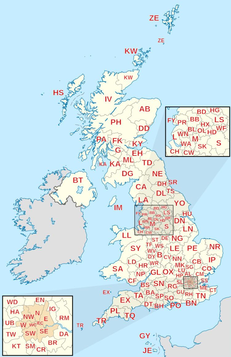
The postcode area is part of the outward code. The postcode area is either one or two characters long and is all letters. Examples of postcode areas include "L" for Liverpool, "RH" for Redhill and "EH" for Edinburgh. A postal area may cover a wide area, for example "RH" covers north Sussex, and "BT" (Belfast) covers the whole of Northern Ireland.
Postcode district
The postcode district is the outward code. It is made of the postcode area plus one or two digits (and sometimes a final letter). The outward code is between two and four characters long. Examples of postcode districts include "W1A", "RH1", "RH10" or "SE1P".
Postcode sector
The postcode sector is made up of the postcode district, the single space, and the first character of the inward code. It is between four and six characters long (including the single space). Examples of postcode sectors include "SW1W 0", "PO16 7", "GU16 7", or "L1 8", "CV1 4".
Postcode unit
The postcode unit is two characters added to the end of the postcode sector. Each postcode unit generally represents a street, part of a street, a single address, a group of properties, a single property, a sub-section of the property, an individual organisation or (for instance Driver and Vehicle Licensing Agency) a subsection of the organisation. The level of discrimination is often based on the amount of mail received by the premises or business. Examples of postcode units include "SW1W 0NY", "PO16 7GZ", "GU16 7HF", or "L1 8JQ".
Validation
The format is as follows, where A signifies a letter and 9 a digit:
Notes:
A postcode can be validated against a table of all 1.7 million postcodes in Code-Point Open. The full delivery address including postcode can be validated against the Royal Mail Postcode Address File (PAF) which lists 29 million valid delivery addresses, constituting most (but not all) addresses in the UK.
Post towns
All, or part, of one or more postcode districts are grouped into post towns. Larger post towns may use more than one postcode district, for example Crawley uses RH10 and RH11. In a minority of cases a single number can cover two post towns – for example, the WN8 district includes Wigan and Skelmersdale post towns.
Crown dependencies
The Channel Islands and the Isle of Man established their own postal administrations separate from the UK in 1969. Despite this they adopted the UK format postcodes, Guernsey in 1993 using GY, the Isle of Man the same year using IM, and Jersey in 1994 using JE.
Overseas territories
Some of the UK's overseas territories have their own postcodes:
These were introduced because mail was often sent to the wrong place, e.g., for St Helena to St Helens, Merseyside and Ascension Island to Asunción, Paraguay, and many online companies would not accept addresses without a postcode. Mail from the UK continues to be treated as international, not inland, and sufficient postage must be used. Royal Mail's Heathrow centre collects all live underpaid mail for surcharging, and there is a reciprocal arrangement with postal services around the world to collect. An agreed payment based on volumes is made, year on year. Other forms of postage are collected at local mail centres, but Heathrow collects those that still get forwarded to them. Bermuda, the UK's most populous remaining overseas territory, has developed its own postcode system, with unique postcodes for street and PO Box addresses, as have the Cayman Islands and the British Virgin Islands. Montserrat recently introduced postal codes, and a system has been under consideration in Gibraltar, and the code GX11 1AA has been introduced as the generic postcode for the territory. Postcodes are not used in the Turks and Caicos Islands and the TKCA 1ZZ designation is generally unknown.
British Overseas Territories typically have a local or UK government postal system operator (see List of postal entities), even if a postal code is assigned by Royal Mail for internal UK routing.
British Forces Post Office (BFPO)
The British Forces Post Office (BFPO) provides a postal service to HM Forces separate from that provided by Royal Mail in the United Kingdom, with BFPO addresses used for the delivery of mail in the UK and around the world. BFPO codes such as "BFPO 801" serve the same function as postal codes for civilian addresses, with the last line of the address consisting of "BFPO" followed a space and a number of 1 to 4 digits.
For consistency with the format of other UK addresses, in 2012 BFPO and Royal Mail jointly introduced an optional alternative postcode format for BFPO addresses, using the new non-geographic postcode area "BF" and the notional post town "BFPO". Each BFPO number is assigned to a postcode in the standard UK format, beginning "BF1". The database was released commercially in March 2012 as part of the Royal Mail Postal Address File (PAF). A postcode is not required if the traditional "BFPO nnnn" format is used.
Non-geographic codes
Most postcodes apply to a geographic area but some are used only for routing and cannot be used for navigation or distance-finding. They are often used for direct marketing and PO boxes. Some postcode sectors or districts are set aside solely for non-geographic postcodes, including EC50, BS98, BT58, BX1-BX9, IM99, M60, N1P, NE99, SA99, SW99 and JE4.
Girobank's headquarters in Bootle used the non-geographic postcode GIR 0AA. Non-geographic postcode area BX is used solely for non-geographic addresses, with codes independent of the location of the recipient. See next paragraph. There is also a special postcode for letters to Santa/Father Christmas, XM4 5HQ.
Special postcodes
Postcodes are allocated by Royal Mail's Address Management Unit and cannot be purchased or specified by the recipient. However, Royal Mail sometimes assigns semi-mnemonic postcodes to high-profile organisations.
Prominent examples include:
The postcode printed on Business Reply envelopes (which do not require a stamp) often ends with the letters BR.
ZZ99
Though not used postally, the National Health Service (NHS) and other public services have a series of pseudo-postcodes, used in records about individual people. These are:
Sorting
Postcodes are used to sort letters to their destination either manually, where sorters use labelled frames, or increasingly with letter-coding systems, where machines assist in sorting. A variation of automated sorting uses optical character recognition (OCR) to read printed postcodes, best suited to mail that uses a standard layout and addressing format.
A long string of "faced" letters (i.e. turned to allow the address to be read) is presented to a keyboard operator at a coding desk, who types the postcodes onto the envelopes in coloured phosphor dots. The associated machine uses the outward codes in these dots to direct bundles of letters into the correct bags for specific delivery offices. With a machine knowledge of the specific addresses handled by each postal walk at each office, the bundles can be further sorted using the dots of the inward sorting code so that each delivery round receives only its own letters. This feature depends upon whether or not it is cost effective to second-sort outward letters, and tends to be used only at main sorting offices where high volumes are handled. When postcodes are incomplete or missing, the operator reads the post town name and inserts a code sufficient for outward sorting to the post town where others can further direct it. The mail bags of letter bundles are sent by road, air or train, and eventually by road to the delivery office. At the delivery office the mail that is handled manually is inward sorted to the postal walk that will deliver it, and it is then "set in", sorted into the walk order that allows the deliverer the most convenient progress in the round. The latter process is now being automated, as the rollout of walk sequencing machines continues.
Integrated Mail Processors
Integrated Mail Processors (IMPs) read the postcode on the item and translate it into two phosphorous barcodes, unique to the inward and outward parts of the postcode, which the machines subsequently print and read, to sort the mail to the correct outward postcode. Letters may also be sequentially sorted by a Compact Sequence Sorter (CSS) reading the outward postcode, in the order that a walking postman/woman will deliver, door to door. On such items the top phosphorous barcode is the inward part of the code, the bottom is the outward.
IMPs can also read RM4SCC items, as used in Cleanmail, a different format to the above.
Mailsort and Walksort
A newer system of five-digit codes called Mailsort was designed for users who send "a minimum of 4,000 letter-sized items". It encodes the outward part of the postcode in a way that is useful for mail routing, so that a particular range of Mailsort codes goes on a particular plane or lorry. Mailsort users are supplied with a database to allow them to convert from postcodes to Mailsort codes and receive a discount if they deliver mail to the post office split up by Mailsort code. Users providing outgoing mail sorted by postcode receive no such incentive since postcode areas and districts are assigned using permanent mnemonics, and do not therefore assist with grouping items together into operationally significant blocks. Walksort was discontinued in May 2012.
Listings and availability
There are approximately 1.7 million postcodes in the United Kingdom (including the Channel Islands and the Isle of Man).
Each postcode is divided by a space into two parts. As mentioned above, the first part is known as a postcode district. Postcode districts with the same one or two letter prefixes are grouped into postcode areas. The second part of a postcode begins with a single digit which indicates the postcode sector within each district.
Postcode areas are also divided into several post towns, which predate the introduction of postcodes, with the London post town uniquely covering more than one postcode area.
As of June 2016, there are 124 postcode areas, 2,987 postcode districts, 11,192 postcode sectors, and 1,500 post towns. Addresses receiving large volumes of mail are each assigned separate "large user" postcodes. But most postcodes are shared by several neighbouring properties, typical covering about 15 addresses.
Life-cycle of post codes
There are also significant numbers of discontinued (terminated) codes. Each month some 2,750 postcodes are created and 2,500 terminated.
Postcode Address File (PAF)
The Address Management Unit of Royal Mail maintains an official database of UK postal addresses and postcodes on its Postcode Address File (PAF), which is made available under licence for a fee regulated by Ofcom. The PAF is commercially licenseable and is often incorporated in address management software packages. The capabilities of such packages allow most addresses to be constructed solely from the postcode and house number. By including the map references of postcodes in the address database, the postcode can be used to pinpoint a postcode area on a map. PAF is updated daily.
On its poweredbypaf.com website, Royal Mail publishes summary information about major changes to postcode sectors and postal localities (including post towns). Individual postcodes or postal addresses can be found using Royal Mail's Postcode and Address Finder website, but this is limited to 50 free searches per user per day.
Code-Point Open
A complete list of all Great Britain postcodes, known as Code-Point Open, has been made available online (since 1 April 2010) by Ordnance Survey. Under the government's OS OpenData initiative, it is available for re-use without charge under an attribution-only licence. The Code-Point Open list includes median coordinates for each postcode but excludes postcodes in Northern Ireland and the Crown dependencies. Unlike the PAF products provided by Royal Mail, the Code-Point Open list does not include postal address text.
ONS Postcode Directory
The Office For National Statistics also produces a postcode list, under similar licence terms to the OS product. The ONSPD does contain Northern Ireland postcodes, with centroid coordinates in the OSI grid as opposed to the OSGB grid, although Northern Ireland postcodes are subject to a more restrictive licence permitting internal business use only. Postcodes for the Crown Dependences are also included, without co-ordinates. A further difference is that non-current postcodes, and dates of introduction and withdrawal of postcodes are included.
Other uses
While postcodes were introduced to expedite the delivery of mail, they are useful tools for other purposes, particularly because codes are very fine-grained and identify just a few addresses. Among uses are:
The phrase "postcode lottery" refers when the availability of services varies by region, though not always because of postcodes.
For these and related reasons, postcodes in some areas have become indicators of social status. Some residents have campaigned to change their postcode to associate themselves with a more desirable area, to disassociate with a poorer area or to be associated with an area with a lower cost of living. In all these cases Royal Mail has said that there is "virtually no hope" of changing the postcode, referring to their policy of changing postcodes only to match changes in their operations.
Postcode areas rarely align with local government boundaries, and a few straddle England's borders with Wales and Scotland. This has led to British Sky Broadcasting subscribers receiving the wrong BBC and ITV regions, and newly licensed radio amateurs being given incorrect call signs.