
 | ||
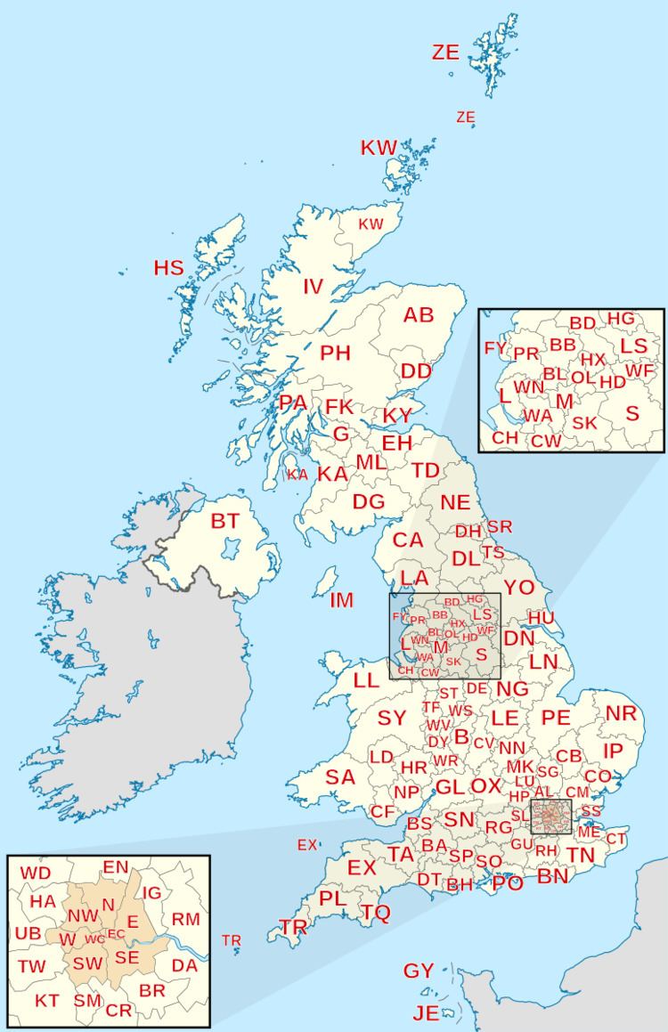
For the purposes of directing mail, the United Kingdom is divided by Royal Mail into postcode areas. The postcode area is the largest geographical unit used and forms the initial characters of the alphanumeric UK postcode. There are currently 121 geographic postcode areas in use in the UK and a further 3 often combined with these covering the Crown Dependencies of Guernsey, Jersey and Isle of Man.
Contents
Subdivision
Each postcode area is further divided into post towns and postcode districts. There are on average 20 postcode districts to a postcode area. The London post town is instead divided into several postcode areas.
Scope
The single or pair of letters chosen for postcode areas are generally intended as a mnemonic for the places served. Postcode areas, post towns and postcode districts do not follow political boundaries and usually serve much larger areas than the place names with which they are associated. For example, within the PA postcode area the PA1 and PA78 postcode districts are 140 miles apart; and the eight postcode areas of the London post town cover only 40% of Greater London. The remainder of its area is covered by sections of twelve adjoining postcode areas: EN, IG, RM, DA, BR, TN, CR, SM, KT, TW, HA and UB.
Crown dependencies
The Crown dependencies (which are not part of the United Kingdom) did not introduce postcodes until later, but use a similar coding scheme. They are separate postal authorities.
Glasgow
Glasgow, like London, was divided into compass districts: C, W, NW, N, E, SE, S, SW. When postcodes were introduced, these were mapped into the new G postcode: C1 became G1, W1 became G11, N1 became G21, E1 became G31, S1 became G41, SW1 became G51, and so on. As NW and SE had never been subdivided they became G20 and G40 respectively.
Norwich and Croydon
Norwich and Croydon were used for a postcode experiment in the late 1960s, which was replaced by the current system. The format was of the form NOR or CRO followed by two numbers and a letter, e.g. NOR 07A.
GIR
GIR 0AA is a postcode created for Girobank in Bootle. It remained in use by its successors when Girobank was taken over by Alliance & Leicester and subsequently by Santander UK.
BF
The BF postcode area was introduced in 2012 to provide optional postcodes for British Forces Post Office addresses, for consistency with the layout of other UK addresses. It uses the national non-geographic post town "BFPO" and, as of 2012, the postcode district "BF1".
BX
The non-geographic postcode area BX has been introduced for addresses which do not include a locality: this allows large organisations long-term flexibility as to where they receive their mail. This postcode area is used by Lloyds Banking Group (BX1 1LT) and parts of the HM Revenue and Customs like VAT Central Unit (BX5 5AT) and Pay as You Earn (BX9 1AS). Lloyds Bank also use BX4. After splitting from Lloyds, TSB Bank uses BX4 7SB, the latter part of which, when written, looks similar to "TSB".
Overseas territories
Certain British overseas territories have postcodes:
These were introduced to prevent mail being sent to the wrong place, e.g., for St Helena to St Helens, Merseyside and Ascension Island to Asunción, Paraguay, and many on-line companies will not accept addresses lacking a postcode. Such mail is treated as international, not inland, so sufficient postage must be used.