
Country United States County Atlantic Time zone Eastern (EST) (UTC-5) Zip code 08241 Population 1,123 (2013) | Incorporated March 1, 1905 Elevation 2.1 m Local time Friday 6:34 AM | |
 | ||
Area rank 226th of 566 in state13th of 23 in county Weather 1°C, Wind SW at 3 km/h, 75% Humidity | ||
Port Republic is a city on the Mullica River, located in Atlantic County, New Jersey, United States. As of the 2010 United States Census, the city had a total population of 1,115, reflecting an increase of 78 (+7.5%) from the 1,037 counted in the 2000 Census, which had in turn increased by 45 (+4.5%) from the 992 counted in the 1990 Census.
Contents
- Map of Port Republic NJ USA
- History
- Geography
- 2010 Census
- 2000 Census
- Government
- Federal state and county representation
- Politics
- Education
- Roads and highways
- Public transportation
- Historic sites
- Notable people
- References
Map of Port Republic, NJ, USA
It is a dry town, where alcohol cannot be sold.
History
Port Republic was settled as early as 1637, but a charter was not applied for until the founders Evi Smith, Hugh McCullum, and Richard Wescoat applied for a Royal charter to build a dam, sawmill, and gristmill on their land along Nacote Creek.
In its early days, Port Republic was known as Wrangleboro. During the American Revolutionary War, Port Republic provided refuge to the residents of the nearby community of Chestnut Neck when the British Army, arriving by ship, sacked their town on October 6, 1778. It had been used as a base by privateers who were capturing goods intended for British forces. Among the refugees was Daniel Mathis, a tavernkeeper who built the Franklin Inn in Port Republic, which is used as a private house today. Some of the British ships were trapped in the creek by the ebb tides. The General Lafayette Chapter of the Daughters of the American Revolution erected a monument on October 6, 1911, to mark the site of the Battle of Chestnut Neck. A Continental Army soldier at the top of the 50-foot (15 m) monument faces the river, "guarding the shore" against the approaching enemy.
In 1842, an effort was made to rename the area from Wrangleborough to Unionville, with a post office to be established under that name. As another Unionville existed in the state, the name "Port Republic" was chosen.
Port Republic was incorporated as a city by an act of the New Jersey Legislature on March 1, 1905, from portions of Galloway Township. The city's name derives from the "U.S. Republic".
Geography
According to the United States Census Bureau, the city had a total area of 8.583 square miles (22.230 km2), including 7.482 square miles (19.378 km2) of land and 1.101 square miles (2.852 km2) of water (12.83%).
Unincorporated communities, localities and place names located partially or completely within the township include Chestnut Neck and Unionville.
The city borders the township of Galloway in Atlantic County, and both Washington and Bass River townships in Burlington County.
The city is one of 56 South Jersey municipalities that are included within the New Jersey Pinelands National Reserve, a protected natural area of unique ecology covering 1,100,000 acres (450,000 ha), that has been classified as a United States Biosphere Reserve and established by Congress in 1978 as the nation's first National Reserve. Part of the city is included in the state-designated Pinelands Area, which includes portions of Atlantic County, along with areas in Burlington, Camden, Cape May, Cumberland, Gloucester and Ocean counties.
2010 Census
The 2010 United States Census counted 1,115 people, 415 households, and 320 families residing in the city. The population density was 149.0 per square mile (57.5/km2). The city contained 444 housing units at an average density of 59.3 per square mile (22.9/km2). The racial makeup of the city was 95.78% (1,068) White, 0.63% (7) Black or African American, 0.45% (5) Native American, 0.90% (10) Asian, 0.00% (0) Pacific Islander, 0.72% (8) from other races, and 1.52% (17) from two or more races. Hispanics or Latinos of any race were 2.96% (33) of the population.
Out of a total of 415 households, 28.9% had children under the age of 18 living with them, 65.8% were married couples living together, 8.7% had a female householder with no husband present, and 22.9% were non-families. 18.3% of all households were made up of individuals, and 4.8% had someone living alone who was 65 years of age or older. The average household size was 2.67 and the average family size was 3.03.
In the city, 22.2% of the population were under the age of 18, 5.7% from 18 to 24, 20.3% from 25 to 44, 39.1% from 45 to 64, and 12.6% who were 65 years of age or older. The median age was 46.1 years. For every 100 females the census counted 92.6 males, but for 100 females at least 18 years old, it was 89.7 males.
The Census Bureau's 2006-2010 American Community Survey showed that (in 2010 inflation-adjusted dollars) median household income was $77,063 (with a margin of error of +/- $5,800) and the median family income was $89,375 (+/- $15,052). Males had a median income of $61,786 (+/- $11,982) versus $38,000 (+/- $4,481) for females. The per capita income for the borough was $36,408 (+/- $4,232). About 2.4% of families and 2.9% of the population were below the poverty line, including 3.2% of those under age 18 and 0.0% of those age 65 or over.
2000 Census
As of the 2000 United States Census there were 1,037 people, 365 households, and 289 families residing in the city. The population density was 136.0 people per square mile (52.5/km2). There were 389 housing units at an average density of 51.0 per square mile (19.7/km2). The racial makeup of the city was 95.08% White, 1.64% African American, 0.39% Native American, 0.58% Asian, 0.00% Pacific Islander, 0.68% from other races, and 1.64% from two or more races. 1.06% of the population were Hispanic or Latino of any race.
There were 365 households out of which 36.7% had children under the age of 18 living with them, 64.9% were married couples living together, 10.1% had a female householder with no husband present, and 20.8% were non-families. 16.7% of all households were made up of individuals and 7.9% had someone living alone who was 65 years of age or older. The average household size was 2.82 and the average family size was 3.17.
In the city the age distribution of the population shows 24.0% under the age of 18, 8.0% from 18 to 24, 26.1% from 25 to 44, 29.9% from 45 to 64, and 12.0% who were 65 years of age or older. The median age was 41 years. For every 100 females there were 96.8 males. For every 100 females age 18 and over, there were 93.1 males.
The median income for a household in the city was $65,833, and the median income for a family was $70,714. Males had a median income of $42,833 versus $34,375 for females. The per capita income for the city was $24,369. 3.5% of the population and 3.2% of families were below the poverty line. Out of the total population, 0.0% of those under the age of 18 and 13.2% of those 65 and older were living below the poverty line.
Government
Port Republic operates under the City form of New Jersey municipal government, led by a Mayor and a seven-member City Council. The City Council consists of one member elected at-large to a four-year term in office and six seats made up of one member elected from both of the city's two wards to three-year terms in a three-year cycle, all of whom are elected in partisan elections on a staggered basis as part of the November general election.
As of 2016, the Mayor of the City of Port Republic is Republican Gary B. Giberson, whose term of office ends December 31, 2017. Members of the City Council are Council President Craig J. Rummler (R, 2018; Ward I), John Bonthron (R, 2016, Ward I), Doris A. Bugdon (R, 2018 Ward II), Nicholas Capille Jr. (R, 2017; Ward I), Roger Giberson (R, 2016; At Large), Donna L. Riegel (R, 2016; Ward II) and Kevin M. Wessler Sr. (D, 2017; Ward II).
Federal, state and county representation
Port Republic is located in the 2nd Congressional District and is part of New Jersey's 9th state legislative district. Prior to the 2011 reapportionment following the 2010 Census, Port Republic had been in the 2nd state legislative district.
New Jersey's Second Congressional District is represented by Frank LoBiondo (R, Ventnor City). New Jersey is represented in the United States Senate by Cory Booker (D, Newark, term ends 2021) and Bob Menendez (D, Paramus, 2019).
For the 2016–2017 session (Senate, General Assembly), the 9th Legislative District of the New Jersey Legislature is represented in the State Senate by Christopher J. Connors (R, Lacey Township) and in the General Assembly by DiAnne Gove (R, Long Beach Township) and Brian E. Rumpf (R, Little Egg Harbor Township). The Governor of New Jersey is Chris Christie (R, Mendham Township). The Lieutenant Governor of New Jersey is Kim Guadagno (R, Monmouth Beach).
Atlantic County is governed by a directly elected executive and a nine-member Board of Chosen Freeholders, responsible for legislation. The executive serves a four-year term and the freeholders are elected to staggered three-year terms, of which four are elected from the county on an at-large basis and five of the freeholders represent equally populated districts. As of 2015, Atlantic County's Executive is Republican Dennis Levinson, whose term of office ends December 31, 2015. Members of the Board of Chosen Freeholders are Chairman Frank D. Formica, Freeholder District 2, including Atlantic City (part), Egg Harbor Township (part), Linwood, Longport, Margate, Northfield, Somers Point and Ventnor (R, 2015), Vice Chairman James A. Bertino, Freeholder District 5, including Buena Borough, Buena Vista Township, Corbin City, Egg Harbor City, Estell Manor, Folsom, Hamilton Township (part), Hammonton, Mullica Township and Weymouth (R, 2015), Colin G. Bell, Freeholder At-Large (R, 2015), John Carman, Freeholder District 3, including Egg Harbor Township (part) and Hamilton Township (part) (R, 2017), Ernest D. Coursey, Freeholder District 1, including Atlantic City (part), Egg Harbor Township (part) and Pleasantville (R, 2016), Richard Dase, Freeholder District 4, including Absecon, Brigantine, Galloway Township and Port Republic (D, 2016), Alexander C. Marino, Freeholder At-Large (R, 2017), Will Pauls, Freeholder At-Large (R, 2016) and John W. Risley, Freeholder At-Large (R, 2017). Constitutional officers are County Clerk Edward P. McGettigan (2016), Sheriff Frank X. Balles (R, 2017) and Surrogate James Curcio (2015).
Politics
As of March 23, 2011, there were a total of 855 registered voters in Port Republic, of which 164 (19.2% vs. 30.5% countywide) were registered as Democrats, 401 (46.9% vs. 25.2%) were registered as Republicans and 289 (33.8% vs. 44.3%) were registered as Unaffiliated. There was one voter registered to another party. Among the city's 2010 Census population, 76.7% (vs. 58.8% in Atlantic County) were registered to vote, including 98.6% of those ages 18 and over (vs. 76.6% countywide).
In the 2012 presidential election, Republican Mitt Romney received 390 votes (57.5% vs. 41.1% countywide), ahead of Democrat Barack Obama with 274 votes (40.4% vs. 57.9%) and other candidates with 10 votes (1.5% vs. 0.9%), among the 678 ballots cast by the city's 896 registered voters, for a turnout of 75.7% (vs. 65.8% in Atlantic County). In the 2008 presidential election, Republican John McCain received 403 votes (58.5% vs. 41.6% countywide), ahead of Democrat Barack Obama with 270 votes (39.2% vs. 56.5%) and other candidates with 12 votes (1.7% vs. 1.1%), among the 689 ballots cast by the city's 872 registered voters, for a turnout of 79.0% (vs. 68.1% in Atlantic County). In the 2004 presidential election, Republican George W. Bush received 390 votes (61.7% vs. 46.2% countywide), ahead of Democrat John Kerry with 228 votes (36.1% vs. 52.0%) and other candidates with 6 votes (0.9% vs. 0.8%), among the 632 ballots cast by the city's 782 registered voters, for a turnout of 80.8% (vs. 69.8% in the whole county).
In the 2013 gubernatorial election, Republican Chris Christie received 317 votes (68.6% vs. 60.0% countywide), ahead of Democrat Barbara Buono with 126 votes (27.3% vs. 34.9%) and other candidates with 11 votes (2.4% vs. 1.3%), among the 462 ballots cast by the city's 899 registered voters, yielding a 51.4% turnout (vs. 41.5% in the county). In the 2009 gubernatorial election, Republican Chris Christie received 294 votes (60.5% vs. 47.7% countywide), ahead of Democrat Jon Corzine with 161 votes (33.1% vs. 44.5%), Independent Chris Daggett with 26 votes (5.3% vs. 4.8%) and other candidates with 3 votes (0.6% vs. 1.2%), among the 486 ballots cast by the city's 845 registered voters, yielding a 57.5% turnout (vs. 44.9% in the county).
Education
Students in public school for kindergarten through eighth grade are educated by the Port Republic School District at Port Republic Elementary School. As of the 2012-13 school year, the district's one school had an enrollment of 113 students and 16.0 classroom teachers (on an FTE basis), for a student–teacher ratio of 7.06:1.
Students in ninth through twelfth grades attend Cedar Creek High School, which is located in the northern section of Egg Harbor City and opened to students in September 2010. The school is one of three high schools operated as part of the Greater Egg Harbor Regional High School District, which also includes the constituent municipalities of Egg Harbor City, Galloway Township, Hamilton Township, and Mullica Township, and participates in sending/receiving relationships with Port Republic and Washington Township (Burlington County). Cedar Creek High School is zoned to serve students from Egg Harbor City, Mullica Township, Port Republic and Washington Township, while students in portions of Galloway and Hamilton townships have the opportunity to attend Cedar Creek through the school of choice program or through attendance in magnet programs offered at Cedar Creek.
Students from Port Republic, and all of Atlantic County, have the option to attend the career technical programs and full-time career academies offered by the Atlantic County Institute of Technology located in the Mays Landing section of Hamilton Township or the Charter-Tech High School for the Performing Arts, located in Somers Point.
Roads and highways
As of May 2010, the city had a total of 23.29 miles (37.48 km) of roadways, of which 8.18 miles (13.16 km) were maintained by the municipality, 9.65 miles (15.53 km) by Atlantic County and 1.81 miles (2.91 km) by the New Jersey Department of Transportation and 3.65 miles (5.87 km) by the New Jersey Turnpike Authority.
The Garden State Parkway passes through the city and is accessible at Interchange 48. U.S. Route 9 passes through Port Republic, as do County Route 575 and County Route 561 Alternate. A small piece of Route 167 is in the city.
Public transportation
NJ Transit provides bus service on the 559 route between Lakewood Township and Atlantic City.
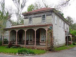
Historic sites
Locations in Port Republic listed on the National Register of Historic Places include the Amanda Blake Store located at 104 Main Street (added January 25, 1979, as building #79001469), and the Port Republic Historic District (added May 16, 1991 as district #91000596), which is roughly bounded by Mill Street, Clark's Landing Road, Adams Avenue, Port Republic-Smithville Road and Riverside Drive.
Notable people
People who were born in, residents of, or otherwise closely associated with Port Republic include: