
Country United States County Atlantic Named for Captain George May Area 4.881 km² Zip code 08330 Area code Area code 609 | State New Jersey Time zone Eastern (EST) (UTC-5) Elevation 4 m Population 2,321 (2000) | |
 | ||
Restaurants Sugar Hill Sub & Deli, The Inn at Sugar Hill, Watering Hole Cafe, Ye Olde Mill St Pub, Frankie's Pizza II | ||
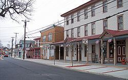
Mays Landing is an unincorporated community and census-designated place (CDP) located within Hamilton Township, Atlantic County, New Jersey, United States. At the 2010 United States Census, the CDP's population was 2,135. It is the county seat of Atlantic County. The community was named for Captain George May, who sailed the Great Egg Harbor River in 1740, and purchased land in the area in 1756.
Contents
- Map of Mays Landing Hamilton Township NJ 08330 USA
- Geography
- Climate
- Census 2010
- Census 2000
- Education
- Transportation
- Wineries
- Notable people
- References
Map of Mays Landing, Hamilton Township, NJ 08330, USA
Geography
According to the United States Census Bureau, Mays Landing had a total area of 1.885 square miles (4.881 km2), including 1.660 square miles (4.299 km2) of land and 0.225 square miles (0.581 km2) of water (11.91%).
The community is located 20 miles (32 km) west of Atlantic City. The community known as Mizpah is located 5 miles (8 km) west of Mays Landing on U.S. Route 40 but is sometimes considered part of it, with ZIP codes of 08330 and 08342. McKee City is an unincorporated area 4 miles (6 km) east of Mays Landing on US 40.
Climate
The climate in this area is characterized by hot, humid summers and generally mild to cool winters. According to the Köppen Climate Classification system, Mays Landing has a humid subtropical climate, abbreviated "Cfa" on climate maps.
Census 2010
The 2010 United States Census counted 2,135 people, 859 households, and 572.1 families residing in the CDP. The population density was 1,286.2 per square mile (496.6/km2). The CDP contained 949 housing units at an average density of 571.7 per square mile (220.7/km2). The racial makeup of the CDP was 88.99% (1,900) White, 5.48% (117) Black or African American, 0.47% (10) Native American, 0.98% (21) Asian, 0.00% (0) Pacific Islander, 1.92% (41) from other races, and 2.15% (46) from two or more races. Hispanics or Latinos of any race were 7.26% (155) of the population.
Out of a total of 859 households, 26.2% had children under the age of 18 living with them, 46.9% were married couples living together, 14.7% had a female householder with no husband present, and 33.4% were non-families. 25.3% of all households were made up of individuals, and 7.1% had someone living alone who was 65 years of age or older. The average household size was 2.46 and the average family size was 2.93.
In the CDP, 20.6% of the population were under the age of 18, 8.9% from 18 to 24, 24.7% from 25 to 44, 33.0% from 45 to 64, and 12.9% who were 65 years of age or older. The median age was 41.7 years. For every 100 females the census counted 92.5 males, but for 100 females at least 18 years old, it was 88.4 males.
Census 2000
At the 2000 United States Census, there were 2,321 people, 892 households and 599 families residing in the CDP. The population density was 527.1/km2 (1,362.8/mi2). There were 952 housing units at an average density of 216.2/km2 (559.0/mi2). The racial makeup of the CDP was 91.25% White, 5.00% African American, 0.09% Native American, 0.73% Asian, 0.22% Pacific Islander, 0.78% from other races, and 1.94% from two or more races. Hispanic or Latino of any race were 3.96% of the population.
There were 892 households of which 33.9% had children under the age of 18 living with them, 49.2% were married couples living together, 14.5% had a female householder with no husband present, and 32.8% were non-families. 27.4% of all households were made up of individuals and 10.3% had someone living alone who was 65 years of age or older. The average household size was 2.55 and the average family size was 3.12.
25.4% of the population were under the age of 18, 7.2% from 18 to 24, 30.9% from 25 to 44, 23.1% from 45 to 64, and 13.4% who were 65 years of age or older. The median age was 37 years. For every 100 females there were 93.1 males. For every 100 females age 18 and over, there were 88.3 males.
The median household income was $52,628 and the median family income was $60,000. Males had a median income of $41,432 compared with $30,154 for females. The per capita income for the CDP was $23,477. About 4.9% of families and 6.8% of the population were below the poverty line, including 14.1% of those under age 18 and 3.0% of those age 65 or over.
The Atlantic County Special Services School is a public school which services students with disabilities from the ages of 3 1/2 to 21.
Education
Mays Landing is served by Oakcrest High School, part of the Greater Egg Harbor Regional High School District. Schools within the Hamilton Township Schools are William Davies Middle School, the George L. Hess Educational complex and the Shaner School.
The Atlantic County Institute of Technology, established in 1974 and located on a campus covering 58 acres (23 ha), provides vocational instruction to high school students and adults from across Atlantic County, and was one of eight schools in the state recognized in 2008 as a Blue Ribbon School by the United States Department of Education.
Saint Vincent de Paul Regional School is a Catholic elementary school serving students in pre-Kindergarten through eighth grade since 1961 and operated under the jurisdiction of the Diocese of Camden.
Atlantic Cape Community College was the second community college to be established in New Jersey, and moved to its campus in Mays Landing in February 1968 where it now serves students from both Atlantic County and Cape May County.
Transportation
NJ Transit provides bus service to Philadelphia on the 315 route and to Atlantic City on the 553 route.
Wineries
Notable people
People who were born in, residents of, or otherwise closely associated with Mays Landing include: