
 | ||
The Vashon Glaciation or Vashon Stade was the most recent period of very cold climate in which glaciers existed at elevations at and near sea level in the western part of present-day Washington (state). It occurred during a colder than present part of the current ice age.
Contents
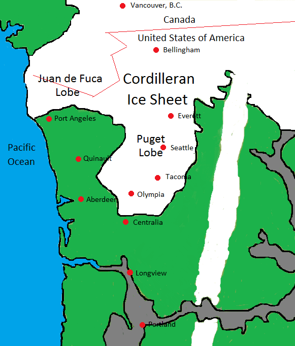
The Vashon Glaciation lasted from about 19,000 - 16,000 BP (Before Present - present defined as January 1, 1950 for this scale). The Cordilleran Ice Sheet was an ice sheet that covered present-day Southern Alaska and parts of western Canada. During the Vashon Glaciation, the Cordilleran Ice Sheet advanced into the Puget Sound region.
Climate
Pollen data collected from Battle Ground Lake in the southern Puget Sound Region shows that from 20,000 - 16,000 BP, annual temperatures in the area were about 6 ± 1 °C (10.8 ± 1.8 °F) colder than in present times (present times as of 1990), and precipitation was around 1 meter (39.4 inches) less. The Battle Ground area averaged 52.14 inches (132.44 cm) of precipitation per year for the period of 1961–1990. A meter less precipitation means that during period of 20,000 - 16,000 BP, the average precipitation would have only been around 24.5% of what it was in the near present 1961–1990 period.
The Laurentide Ice Sheet had a major effect on the climate. It was an ice sheet covering much of Canada, and parts of the northern United States in the Midwest and east. The Rocky Mountains separated the Laurentide Ice Sheet from the Cordilleran Ice Sheet. The Laurentide Ice Sheet had a cooling effect on the middle latitudes. This caused the jet stream over North America to split in two. The southern branch was pushed further south than it is in present times meaning that the storm tracks were missing the Pacific Northwest most of the time. Because of this, Southern and Central California had wetter climates than in present times.
Average annual temperatures in the lowlands of Western Washington were above 0 °C (32 °F). This means that there was more summer thawing than there was winter freezing. This would seem to be a climate too warm to support glaciers, but the ice was pushing in from the north faster than it could melt.
The advance
During the Vashon Glaciation, the Cordilleran Ice Sheet grew and advanced southwards at a rate of about 135 metres (443 ft) per year. It crossed the present-day Canada–United States border around 19,000 BP. This part of the Cordilleran Ice Sheet is called the Puget Lobe. The Vashon Glaciation actually began after the global glacial maximum. Glaciers were retreating throughout most of the world, but growing in Western Washington. Around 18,350 BP, the Puget Lobe blocked the Puget Sound from reaching the Strait of Juan de Fuca, turning the Puget Sound into Glacial Lake Russell. By around 17,950 BP, the glacier reached present-day Seattle. By around 17,650 BP, the Puget Lobe reached present-day Tacoma. By around 17,350 BP, the glacier reached present-day Olympia. The Puget Lobe reached its maximum extent in the vicinity of the present-day city of Tenino around 16,950 BP.
The maximum extent
The Puget Lobe remained at its maximum extent in the vicinity of present-day Tenino from around 16,950 BP to around 16,850 BP, a total of about 100 years. The ice depths were about 1.6 kilometres (0.99 mi) at the present-day Canada–United States border, 1,000 metres (3,300 ft) in Seattle, and 200 metres (660 ft) at the glacier's terminus in the Tenino area.
The retreat
Around 16,850 BP, the Puget Lobe began retreating northward at a rate of about 340 meters (1,120 feet) per year. By about 16,650 BP, the glacier only came down to present-day Olympia. The Puget Lobe began to uncover Glacial Lake Russell. By 16,450 BP, the Puget Lobe only came down to Tacoma. By 16,150 BP, the glacier only came down to Seattle. By about 16,000 BP, the Puget Lobe retreated far enough north that Glacial Lake Russell and the Straight of Juan de Fuca became connected, making Glacial Lake Russell the salt water body of Puget Sound again.
For areas on land, as the Puget Lobe receded, blocks of ice broke off and became separate. The melting glacier produced streams which carried sediment. The bottom of the ice blocks became buried in sediment. As the blocks of ice melted, it left depressions in the ground called kettles. Some of these kettles filled up with water to become kettle lakes and kettle ponds. (see Kettle (landform))
Glacial Lake Carbon was a lake created by the Puget Lobe damming the Carbon River. Around 16,850 BP when the glacier began retreating, the ice dam holding back the lake became breached causing a major glacial outburst flood. The flood covered present day central and northern Thurston County, part of Pierce County, and small parts of Lewis and Grays Harbor Counties.
Humans
At this time, no scientific evidence has been found indicating that human beings were in the area during the Vashon Glaciation. The oldest known human artifacts in the area are from 13,800 BP.