
First ascent 1864 | Elevation 3,143 m Prominence 1,277 m Parent peak Montcalm Massif | |
 | ||
Similar Pic de Montcalm, Pic de Sotllo, Pic Verdaguer, Punta Gabarró, Monteixo | ||
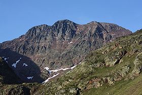
Pica d'Estats (Catalan: Pica d'Estats, French: Pic d'Estats) is a 3,143-metre-high (10,312 ft) mountain in the Montcalm Massif, Pyrenees. on the Spanish–French border, and is the highest mountain in Catalonia.
Contents
Map of Pica d'Estats
This mountain is included in the Parc Natural de l'Alt Pirineu.
SummitsEdit
The summit is located between the Catalan municipality of Alins in Pallars Sobirà and the French district of Ariège. It comprises three peaks, all lying close to each other:
This eastern peak is the geodesic vertex. The ridge runs north-northwest to southeast along the Spanish–French border.
References
Pica d'Estats Wikipedia(Text) CC BY-SA