
Parent range Pyrénées Elevation 3,077 m | ||
 | ||
Similar Pica d'Estats, Pic de Sotllo, Pic Verdaguer, Punta Gabarró, Rodó de Canalbona | ||
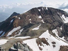
Pic de Montcalm is a French pyrenean summit, culminating at 3,077 m (10,095 ft), located in the Ariège department, Midi-Pyrénées region of France.
Contents
Map of Pic de Montcalm, 09220 Auzat, France
TopographyEdit
Located in the Ariège south of Auzat in the Vicdessos, it lies slightly north of the Franco-Spanish borderline crest.
La pique du Montcalm (Ariège appellation), la pique d'Estats and the pic du port de Sullo are the three main summits of the massif du Montcalm, the last two bordering Spain and la Pica d'Estats the highest summit in Catalonia.
The summit is located in the perimeter of the parc naturel régional des Pyrénées ariégeoises.
HistoryEdit
The first ascent was made on July 18, 1807 by Augustin Pyramus de Candolle along with guide Simon Faure
AccessEdit
On the French side, three main itineraries are possible :
On the Spanish side: by the Val Ferrera, from the Pica d'Estats from which one can reach the Montcalm by the col de l'Estats, French side.