Area 162.7 km² | Region Occitanie Population (2010) 582 Local time Friday 8:58 AM | |
 | ||
Weather 7°C, Wind S at 10 km/h, 74% Humidity Points of interest Pic de Montcalm, Pic Verdaguer, Punta Gabarró, Étang de Soulcem, Rodó de Canalbona | ||
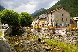
Auzat is a French commune in the Ariège department in the Occitanie region of south-western France.
Contents
- Map of 09220 Auzat France
- Geography
- Hamlets and places in the commune
- Environment
- History
- Administration
- Twinning
- Demography
- Civil heritage
- Religious heritage
- Notable people linked to the commune
- References
Map of 09220 Auzat, France
The inhabitants of the commune are known as Auzatois or Auzatoises.
The commune has been awarded one flower by the National Council of Towns and Villages in Bloom in the Competition of cities and villages in Bloom.
Geography
Auzat is located some 45 km south by south-west of Pamiers and 40 km north by north-west of Andorra la Vella. Its south-western border is the border between France and Spain and its south-eastern border is the border between France and Andorra. Access to the commune is by road D8 which branches from the D18 at Vicdessos and goes to the village then continues south to access the dam at Etang de Soulcem. Due to the extremely rugged terrain there is no access to Spain or Andorra from the commune. Its highest point is the Pica d'Estats (3143 m), which is located in the Montcalm Massif, exactly on the Spanish border.
Many streams rise in the south of the commune and flow north in two parallel main streams - the Ruisseau de la Coume de Subra and the Ruisseau de Mounicou. The Ruisseau de la Coume de Subra joins the Ruisseau de l'Artigue flowing east to join the Ruisseau de Mounicou which continues north to the village where it becomes the Ruisseau de Vicdessos then continues east to join the Ariege at Tarascon-sur-Ariège. There are also many lakes in the south of the commune with the Etang de Soulcem being the largest.
Hamlets and places in the commune
Environment
The commune has a rich environment in terms of Wilderness and ecological potential but industrialization has left traces: in particular the disused Pechiney Aluminium Smelter (closed in 2003) left heavy environmental consequences.
The smelter was ranked 2 under Directive 96/82/EC (Seveso). The plant had an internal landfill site of 1.8 hectares located several kilometres from the smelter site at a place called Massada on the border with Vicdessos commune. This discharge area, as well as the groundwater and soil that supported the plant operations, are polluted by various pollutants including fluorides, cyanides, hydrocarbons, arsenic, aluminium, and barium.
History
Administration
List of Successive Mayors
(Not all data is known)
Twinning
Since 2003, the Auzat valley and Vicdessos have developed special links with Italy, especially with the Veneto and Friuli regions which were the origins of the victims of the Izourt Dam disaster in Auzat that had resulted in the deaths of 29 Italians and 3 Frenchmen on 24 March 1939. The Ricordate Association, with the support of elected officials, regularly organizes events and commemorations for the victims' families to honour their dead and to better understand the circumstances of the accident.
Demography
In 2010 the commune had 582 inhabitants. The evolution of the number of inhabitants is known from the population censuses conducted in the commune since 1793. From the 21st century, a census of communes with fewer than 10,000 inhabitants is held every five years, unlike larger communes that have a sample survey every year.
Sources : Ldh/EHESS/Cassini until 1962, INSEE database from 1968 (population without double counting and municipal population from 2006)
Civil heritage
Religious heritage
The commune has several religious buildings:
