
Basin size 850 km (330 sq mi) Basin area 850 km² | River mouth Creuse202 m (663 ft) Length 95 km | |
 | ||
Main source In Treignat490 m (1,610 ft) Discharge Average rate:8.75 m/s (309 cu ft/s) | ||
In monets footsteps a large en pleine air acrylic la petite creuse
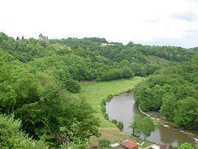
The Petite Creuse (French: la Petite Creuse, the small Creuse) is a 95.2 km (59.2 mi) long river in Allier and Creuse départements, in central France. Its source is at Treignat, 2.5 km (1.6 mi) southeast of the village. It is a left tributary of the Creuse River into which it flows at Fresselines. The river is dammed at several locations creating valley lakes that are extensively used for recreation such as fishing, boating and swimming. The dams are used to generate electricity and to provide water treatment plants providing drinking water to local communities.
Contents
- In monets footsteps a large en pleine air acrylic la petite creuse
- Dpartements and communes along its course
- References
Départements and communes along its course
This list ist ordered from source to mouth:
References
Petite Creuse Wikipedia(Text) CC BY-SA