
Area 28.24 km² | Canton Châtelus-Malvaleix Population (2008) 359 Local time Thursday 6:24 PM | |
 | ||
Weather 9°C, Wind E at 10 km/h, 57% Humidity | ||
Bétête is a commune in the Creuse department in the Nouvelle-Aquitaine region in central France.
Contents
Map of 23270 B%C3%A9t%C3%AAte, France
Geography
A farming area comprising the village and several hamlets situated some 15 miles (24 km) northeast of Guéret, at the junction of the D15, D83 and the D88. The Petite Creuse river forms most of the southern and western border of the commune.
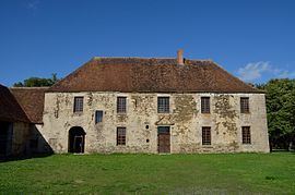
Sights
References
Bétête Wikipedia(Text) CC BY-SA