
Council Dobre Village Council Time zone MSK (UTC+4) | Elevation 438 m (1,437 ft) Population 3,660 (2001) | |
 | ||
Weather 1°C, Wind N at 6 km/h, 98% Humidity | ||
Russian forces tighten grip on perevalne military base in crimea
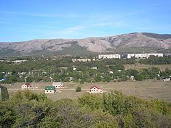
Perevalne (Ukrainian: Перевальне; Russian: Перевальное (Perevalnoye); Crimean Tatar: Anğara, Ангъара) (until 1945, Angara) is a village in Crimea, a disputed territory recognized by a majority of countries as part of Ukraine but administered by Russia as the Republic of Crimea. The village of Perevalne is administered by the Dobre Village Council, which in turn is subordinate to Crimea's Simferopol Raion (district) authorities.
Contents
Map of Pereval'ne
According to the 2001 Ukrainian census, its population was 3,660. The village is located in the middle of the Crimean Mountains, next to the Chatyr-Dag massif. The Simferopol—Alushta—Yalta highway runs through the village, as well as the Crimean Trolleybus line, which has a stop in the settlement.
There is a garrison (воинская часть A-2320) in Pevevalne. Former Soviet trainning center for special forces. The Ukrainian 36th separate machanised coastal infantry brigade is located there and during the Crimean crisis 2014 was surrounded by the Russian troops without military rank insignia or cockade.