
Length 111.9 km | Constructed 1928 | |
 | ||
Counties | ||
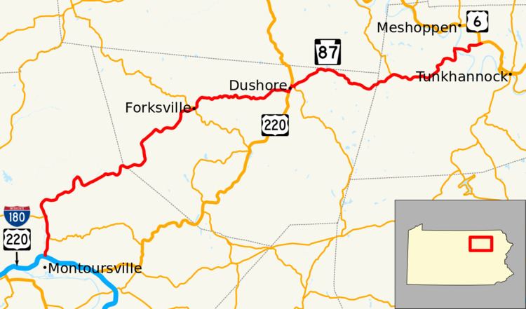
Pennsylvania Route 87 (PA 87) is a 69.3-mile-long (111.5 km) north–south state highway located in northern Pennsylvania. The southern terminus of the route is at exit 21 of Interstate 180 and U.S. Route 220 in Montoursville. The northern terminus is at U.S. Route 6 in Washington Township.
Contents
Map of PA-87, Pennsylvania, USA
The road is called Loyalsock Avenue at its southern terminus in Montoursville. It joins PA 154 for 200 yards (180 m) in Forksville and US 220 for 1,200 yards (1,100 m) in Dushore. While in Dushore, it serves as the northern terminus of PA 487, and is also known as South German Street, East Main Street, Mill Street, and Carpenter Street.
Lycoming County
PA 87 begins at an interchange with I-180/US 220 in Montoursville, Lycoming County, heading north on Loyalsock Avenue, a two-lane divided highway. The route immediately crosses into Fairfield Township and becomes an undivided, unnamed road, running between farmland to the west and woodland with homes to the east. The road continues into Upper Fairfield Township and heads through more agricultural areas with some residences, intersecting the western terminus of PA 864 in Farragut. PA 87 heads through more farmland and woodland with some homes to the east of the Loyalsock Creek, passing through Loyalsockville and coming to an intersection with the eastern terminus of PA 973. The road passes through more farm fields with some woods and residences in a narrow valley, crossing into Plunketts Creek Township as it heads north-northwest. The route curves to the north and the northeast before heading east into dense forests alongside the creek, heading to the northeast and continuing through scattered tracts of the Loyalsock State Forest. PA 87 heads north through more forests with a few homes, turning northeast before heading southeast. The road runs northeast through woods with a few fields and residences, curving east before turning north into more dense forests.
Sullivan County
PA 87 enters Hillsgrove Township in Sullivan County and turns east, passing through more forests along the south bank of the Loyalsock Creek. The road continues through more forested areas with a few fields and homes, curving northeast and north. The route crosses the creek and turns northeast into agricultural areas, passing through the residential community of Hillsgrove. PA 87 runs through more farmland with some woods and homes, crossing Loyalsock Creek again and turning southeast into forests. The road curves northeast again and heads into more forested areas with some fields, heading east before crossing into Forks Township and continuing northeast through more rural areas. The route heads north before a turn to the east, heading into Forksville. Here, PA 87 passes through rural areas of homes and businesses, crossing the Loyalsock Creek and coming to an intersection with PA 154. At this point, PA 154 turns east to form a brief concurrency with PA 87, crossing the Little Loyalsock Creek. After this, PA 154 splits from PA 87 by turning northwest and PA 87 heads into forests, turning north and crossing back into Forks Township. The road continues into a narrow agricultural valley with some woods and homes, curving east at Millview. The route heads east into more forested areas to the north of Little Loyalsock Creek. PA 87 crosses into Cherry Township and runs through more forests with some fields and residences, curving northeast before heading back to the east. The route comes to an intersection with US 220, at which point PA 87 turns north to join US 220 on German Street, heading through wooded areas of homes as it enters Dushore. The road heads into the commercial center of Dushore, where PA 87 splits from US 220 by turning east onto East Main Street. The route continues onto Mill Street, passing homes and coming to an intersection with the northern terminus of PA 487, at which point it turns north onto Carpenter Street, heading northeast through more residential areas. The road crosses back into Cherry Township and becomes an unnamed road, passing through a mix of farmland and woodland with some homes. The route turns east and winds through more rural areas, entering Colley Township. PA 87 curves to the southeast and passes through Colley. The road continues east into dense forests, turning to the northeast.
Wyoming County
PA 87 heads into North Branch Township in Wyoming County and continues east and northeast through more forests with occasional homes. The road comes to an intersection with the southern terminus of PA 187 near Lovelton and turns east into more rural areas. The route winds east and enters Forkston Township, running through more woodland with some farm fields and residences. PA 87 crosses the Mehoopany Creek and turns northeast, passing through more rural areas to the southeast of the creek and heading into Mehoopany Township. The road winds northeast through more farmland and woodland with some homes, crossing the Mehoopany Creek again and heading into the residential community of Mehoopany. The route continues through wooded areas of homes and passes through North Mehoopany, turning east to cross the Susquehanna River into Washington Township, passing over a Norfolk Southern railroad line immediately after the river. The road heads near industrial areas before turning north into woods. PA 87 continues east into agricultural areas with some woods and homes, coming to its northern terminus at an intersection with US 6.