
Existed: 1959 – present Constructed 1959 | Length 44.56 km | |
 | ||
North end: PA 611 in Stroud Township Counties Northampton County, Pennsylvania, Monroe County, Pennsylvania | ||
Pennsylvania Route 33 (PA 33) is a 27.7-mile-long (44.6 km) limited-access state highway in eastern Pennsylvania, United States. It runs from an interchange with Interstate 78 (I-78) just south of Easton to I-80 and PA 611 west of Stroudsburg. Until 2003, the route's southern terminus was at U.S. Route 22 (US 22), and the extension south of the US 22 interchange is known as the Gen. Anthony Clement McAuliffe 101st Airborne Memorial Highway. The route is commonly used as a hazmat bypass for the Pennsylvania Turnpike's Northeast Extension due to the restrictions in place on the Lehigh Tunnel.
Contents
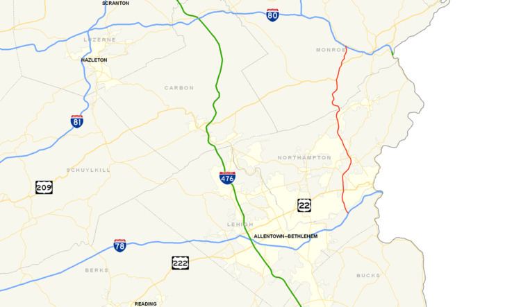
Map of PA-33, Pennsylvania, USA
Route description
PA 33 begins at a trumpet interchange with I-78 in southern Northampton County. Just north of this interchange, the route crosses the Lehigh River on the Gene Hartzell Memorial Bridge. After this crossing, the highway briefly cuts through the southwestern tip of the city of Easton. PA 33 then bends to the north and shares interchanges with Freemansburg Avenue and William Penn Highway. North of here, the highway intersects its former southern terminus, US 22, at a cloverleaf interchange.
After two more exits for Hecktown Road and PA 248, the freeway curves to the northeast and crosses Bushkill Creek, entering the borough of Stockertown. In Stockertown, the highway intersects PA 191 at a diamond interchange, then turns northwestward. After leaving Stockertown, PA 33 intersects Henry Road, which connects it to the community of Belfast. Continuing in a northerly direction, the route intersects PA 512 and Broadway, both of which link it to Wind Gap to the east. At the intersection with Broadway, the route crosses the Blue Mountain ridge and enters Monroe County.
In Monroe County, the highway's northbound lanes intersect Cherry Valley Road, whilst its southbound lanes intersect Wilkes Barre Turnpike. Both roads connect PA 33 to Saylorsburg. North of Saylorsburg, the freeway intersects US 209 at a trumpet interchange, and the two routes run concurrently northward. The highways bend slightly to the northeast and intersect Manor Road before US 209 leaves PA 33 and heads east, while PA 33 continues northeastward. The highway then turns north and meets its northern terminus at an interchange with I-80 and PA 611.
History
The construction of PA 33 started in 1959, and stretched from the Route 512 interchange to Saylorsburg. Construction finished in 1960. The stretch connecting the highway to Interstate 80 was built and completed by 1964. Construction on Route 33 was not continued until 1969 when work began on the stretch from Route 512 in Wind Gap to Henry Road in Belfast. This stretch was completed by 1970. By 1972, the road had reached what is now Route 191 in Stockertown, and was extended down to its long-term end terminus at US-22. The highway was left at that until 1999 when construction began on a final segment that would connect the Route 22 interchange to Interstate 78. The final three-mile (5 km) stretch opened in January 2002.
In January 2004, the expressway was shut down between Lower Nazareth Township (Route 248) and Stockertown (Route 191) because of a sinkhole that was in the area of the Bushkill Creek directly under a northbound bridge support beam. Crossovers were created, narrowing the highway to one lane in each direction through Stockertown. Studies were conducted, and came to the conclusion that the bridge was dangerous and could not be fixed. The northbound bridge was demolished in February of the same year. Just 21 days later, a sinkhole was discovered under the southbound bridge over the Bushkill Creek, and resulted in the demolition of the southbound bridge. Once the new northbound bridge was completed, another crossover was created, detouring southbound traffic onto the northbound side of the highway. On April 21, 2004, a depression formed under the new northbound bridge, and the highway was shut down once again to fill the area with bituminous material. The bridge re-opened within twenty minutes. By November 19, 2004, both bridges were completed and opened. All of this happened feet from the Bushkill Street Bridge, which connects Stockertown and Palmer Township, and has been closed since 1999 because of numerous sinkholes causing the bridge to collapse.
On March 21, 2009, a tractor-trailer carrying 32,000 pounds of hydrofluoric acid overturned on southbound Route 33 in Plainfield Township, prompting the evacuation of about 5,000 people. The truck, registered to the Honeywell company, flipped over at about 2:40 a.m. after the driver swerved to avoid a deer. Nobody was injured and the highway was reopened later that day. Hundreds of evacuees were taken to the Pen Argyl Area High School in nearby Pen Argyl.
On January 31, 2013, ground was broken for a new interchange at Main Street in Palmer Township to the west of Tatamy, with Governor Tom Corbett in attendance. This interchange is being constructed to serve the Palmer Industrial Park and is expected to bring economic development to the area. Completion of this interchange, which is to cost $40 million, was originally planned for November 2014. However, work on the project was halted during the winter of 2014-2015, with completion pushed back to June 2015.