
Elevation 6,293 ft (1,918 m) Country United States | Length 26 mi (42 km) N-S | |
 | ||
Peak Peacock Peak (Arizona) (center of range, ridgeline to north) Width 10 mi (16 km) (about 14-mi at south) Similar Hualapai Mountains, Mohave Mountains, Muggins Mountains, Growler Mountains, Buckskin Mountains | ||
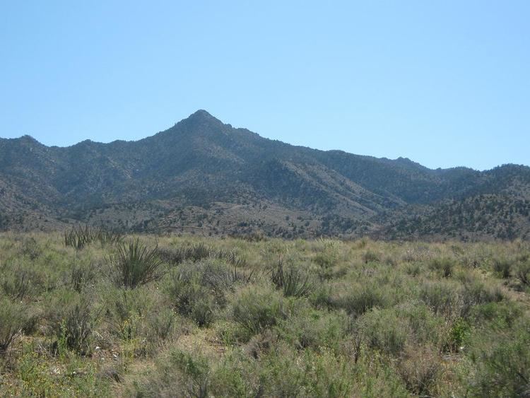
The Peacock Mountains are a small, 26-mi (42 km) long mountain range in northwest Arizona, USA. The range is a narrow sub-range, and an extension north, at the northeast of the Hualapai Mountains massif, which lies to the southwest. The range is defined by the Hualapai Valley to the northwest, and north and south-flowing washes on its east border, associated with faults and cliffs; the Cottonwood Cliffs (Cottonwood Mountains) are due east, and are connected to the Aquarius Cliffs southward at the west perimeter of the Aquarius Mountains; the cliffs are a result of the Aquarius Fault, which is an extension southward from the Grand Wash Cliffs and Grand Wash Fault which crosses the Colorado River at Lake Mead, and the west perimeter of the Grand Canyon/Colorado Plateau.
Contents
- Map of Peacock Mountains Arizona 86411 USA
- DescriptionEdit
- Vegetation communitiesEdit
- Great Basin Grassland Great Basin Conifer WoodlandEdit
- References
Map of Peacock Mountains, Arizona 86411, USA
DescriptionEdit
The Peacock Mountains, are a smaller, lower elevation range, only about 10-mi (16 km) wide. Peacock Peak (Arizona), 6,293 feet (1,918 m) is the range highpoint, in the approximate center of the range, with a ridgeline north to the range terminus (13-mi). At the north terminus, Arizona State Route 66 transits northeast to southeast around the range; the Grand Wash Cliffs lie due north; the northwest-trending Hualapai Valley extends from the terminus, and the Grand Wash Cliffs form its east border, also forming the southwest border of the Music Mountains; the cliffs extend approximately 100-mi northwards approaching southwest Utah.
The east side of the Peacock Mountains are defined by due-north and due-south flowing drainages on the west of the Cottonwood Cliffs. At the approximate mountain range center, a water divide finds Hackberry Wash flowing due-north to Truxton Wash, which descends from the northeast, (off east Music Mountains, and west region Aubrey Valley). Truxton Wash meets the northeast of the Peacock Mountains, then turns due northwest at the Peacock Mountains foothills, to enter the southeast of Hualapai Valley.
At the southeast of the Peacock Mountains, the headwaters of the south-flowing Knight Creek begins. Within 25-mi from the water divide the creek becomes the Big Sandy River. The southern section of the Peacock Mountains also widens to about 14-mi, with McCarrys Wash feeding east off the northeast of the Hualapai Mountains, and numerous other washes feeding from the south and southeast off the Peacock Mountains into Knight Creek.
Vegetation communitiesEdit
The Peacock Mountains lie at a regional confluence of five vegetation biotic communities. Mohave Desertscrub has a limit to the north (in the Grand Canyon, along the Colorado River), and is located northwest, west, and southwest of the Peacock Mountains/Kingman, Arizona region; also northwest, at the north of Hualapai Valley. To the south, the north limits of the 'Arizona Upland Sonoran Desert-scrub' is found up the Big Sandy River and its tributaries, which is north-south along the Aquarius Fault, the fault being the Grand Wash Cliffs southern extension. Another lower elevation community is the Semidesert Grassland, found especially in southeast Arizona, (middle elevation locales, Madrean Sky Islands region, Cochise County), but the zone extends northwestwards along the Arizona transition zone mountains and valleys, higher elevation grassland at the base of the northwest–by–southeast lineage of the Mogollon Rim, and associated ridges or plateaus (Mogollon Plateau); the Semidesert Grassland reaches its terminus northwest up the Big Sandy River and west to the Sacramento Valley at the west of Kingman, and northwards up into Detrital Valley.
Great Basin Grassland, Great Basin Conifer WoodlandEdit
Two higher elevation biotic communities find their west limits at the Peacock Mountains region. Upstream up Truxton Wash to the northeast, is a region of Plains and Great Basin Grassland along the Truxton Wash and mountain foothills; further east and northeast, on the west of the Coconino Plateau, (Hualapai Indian Reservation, and Aubrey Valley region), a large mostly continuous expanse of the grassland exists. The grassland is surrounded and intermixed with the 2nd higher elevation biotic community, Great Basin Conifer Woodland. Together, the woodland and the grassland encompass almost the entire north half of Arizona except for specific regions of desert (Painted Desert, the Great Basin Desertscrub, on the Colorado Plateau, or associated perimeter regions). Other exceptions are the highpoint communities of trees or alpine grasslands at the San Francisco Peaks region, or the Kaibab Plateau on the Grand Canyon North Rim, or a few other higher altitude locales. (The exceptions are the Subalpine Grassland, found especially in the White Mountains, or small areas at the San Francisco Peaks, and the Rocky Mountain Subalpine Conifer Forest found at both the White Mountains and San Francisco Peaks.)