
Area 19,425 km² | ||
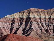 | ||
The Painted Desert is a United States desert of badlands in the Four Corners area running from near the east end of the Grand Canyon National Park southeast into the Petrified Forest National Park. It is most easily accessed in the north portion of The Petrified Forest National Park. The Painted Desert is known for its brilliant and varied colors, that not only include the more common red rock, but even shades of lavender.
Contents
Map of Painted Desert, Arizona 86031, USA
The Painted Desert was named by an expedition under Francisco Vázquez de Coronado on his 1540 quest to find the Seven Cities of Cibola, which he located some forty miles east of The Petrified Forest National Park. Finding the cities were not made of gold, Coronado sent an expedition to find the Colorado River to resupply him. Passing through the wonderland of colors, they named the area "El Desierto Pintado" - The Painted Desert.
Much of the Painted Desert within the Petrified Forest National Park is protected as the Petrified Forest National Wilderness Area where motorized travel is limited. But the park offers both easy and longer hikes into the colored hills. The Painted Desert continues north into the Navajo Nation where off-road travel is by permit.
Geology
The desert is composed of stratified layers of easily erodible siltstone, mudstone, and shale of the Triassic Chinle Formation. These fine grained rock layers contain abundant iron and manganese compounds which provide the pigments for the various colors of the region. Thin resistant lacustrine limestone layers and volcanic flows cap the mesas. Numerous layers of silicic volcanic ash occur in the Chinle and provide the silica for the petrified logs of the area. The erosion of these layers has resulted in the formation of the badlands topography of the region.
In the southern portions of the desert the remains of a Triassic period coniferous forest have fossilized over millions of years. Wind, water and soil erosion continue to change the face of the landscape by shifting sediment and exposing layers of the Chinle Formation. An assortment of fossilized prehistoric plants and animals are found in the region, as well as dinosaur tracks and the evidence of early human habitation.
Area and climate
The Painted Desert extends roughly from Cameron–Tuba City southeast to past Holbrook and the Petrified Forest National Park. The desert is about 120 miles (190 km) long by about 60 miles (97 km) wide, making it roughly 7,500 square miles (19,425 km2) in area. Bordering southwest and south is the Mogollon Plateau, and on the plateau's south border the Mogollon Rim, the north border of the Arizona transition zone.
Owing to the strong rain shadow of the Mogollon Rim, the Painted Desert has a cold desert climate (Köppen BWk), with hot, dry summers and cold, though virtually snow-free winters. The annual precipitation is the lowest in northern Arizona and in many places is lower even than Phoenix.
Accessibility
Much of the region is accessible only by foot or unpaved road though major highways and paved roads cut across the area. The towns of Cameron and Tuba City, both on the Navajo Nation, are two major settlements. A permit is required for all backroad travel on the Navajo Nation.