
Country United States Primary Siltstone, Sandstone | Other paleosols Named for Chinle | |
 | ||
Sub-units Shinarump Conglomerate, Mesa Redondo Member, Bluewater Creek Member, Blue Mesa Member, Sonsela Member, Moss Back Member, Petrified Forest Member, Owl Rock Member, Rock Point Member, Church Rock Member Underlies | ||
Triassic chinle formation the rocks of utah
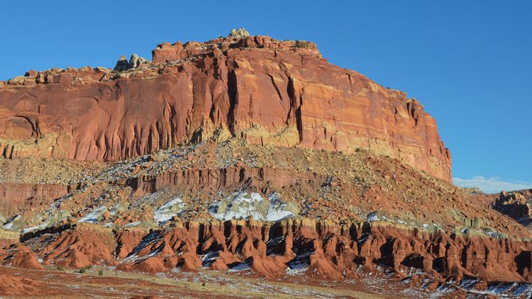
The Chinle Formation is an Upper Triassic continental geologic formation of fluvial, lacustrine, and palustrine to eolian deposits spread across the U.S. states of Nevada, Utah, northern Arizona, western New Mexico, and western Colorado. The Chinle is controversially considered to be synonymous to the Dockum Group of eastern Colorado and New Mexico, western Texas, the Oklahoma panhandle, and southwestern Kansas. The Chinle is sometimes colloquially named as a formation within the Dockum Group in New Mexico and in Texas. The Chinle Formation is part of the Colorado Plateau, Basin and Range, and the southern section of the Interior Plains.
Contents
- Triassic chinle formation the rocks of utah
- History of investigation
- Stratigraphy
- Ages of Chinle Members
- Subunits
- Places found
- References
A probable separate depositional basin within the Chinle is found in northwestern Colorado and northeastern Utah. The southern portion of the Chinle reaches a maximum thickness of a little over 520 m. Typically, the Chinle rests unconformably on the Moenkopi Formation.
History of investigation
There is no designated type locality for this formation. It was named for Chinle Valley in Apache County, Arizona by Herbert E. Gregory in 1917 without officially designating it as the formation's name until two years later and without a specified type locality. United States Geological Survey economic geologist Raymond C. Robeck in 1956 revised the unnamed members of Gregory by identifying and naming the Temple Mountain member as the basal-most unit in the area of the San Rafael Swell of Utah. In 1957 John H. Stewart revised the Shinarump Conglomerate of G. K. Gilbert, 1875, and Edwin E. Howell, 1875, and Gregory, 1917, and renamed it the Shinarump member of the Chinle formation. An overview of the geology of the area was created by USGS geologist Forrest G. Poole and Stewart in 1964. Sikich revised the unit and assigned more members assigned in 1965. The areal extent of the unit was mapped by Wilson and Stewart in 1967. In 1972 the areal limits were modified and an overview created by Stewart and others (they published a revision the same year). Kelley assigned more members and revised the unit in 1972. Lucas and Hayden did the same thing in 1989. The Rock Point Member was assigned by Dubiel in 1989. The Chinle was raised to group status by Lucas in 1993, thus also raising many of the members to formation status. He also included the formations of the Dockum Group of eastern New Mexico and west Texas within the "Chinle Group" . This modified nomenclature is controversial; many still retain the Chinle as a formation and separate out the Dockum Group (e.g., USGS). The Dockum was named in 1890, before the Chinle. If Lucas is correct, his "Chinle Group" should be named the Dockum Group due to stratigraphic nomenclature rules. Overviews of the Chinle were created by Dubiel and others (1992) and Hintze and Axen (1995).
Stratigraphy
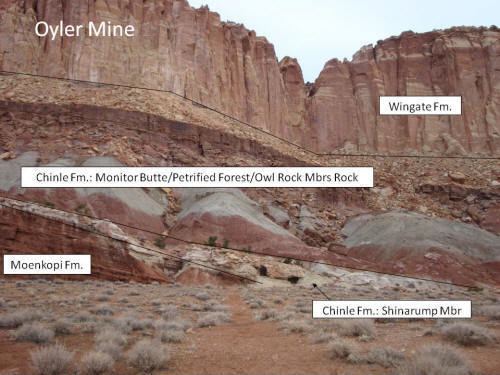
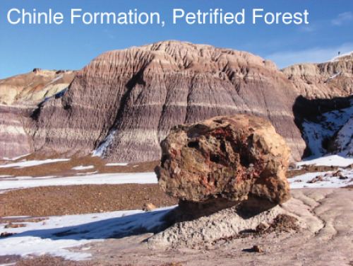
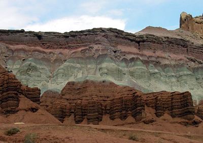
The formation members and their thicknesses are highly variable across the Chinle. The stratigraphically lowest formation is the Temple Mountain Member. However, in most areas, the basal member is the Shinarump Member. The Shinarump is a braided-river system channel-deposit facies. The Monitor Butte Member overlies the Shinarump in most areas. The Monitor Butte is an overbank (distal floodplain) facies with lacustrine deposits. This is overlain in western areas by the channel-deposit facies Moss Back Member. More commonly, the Monitor Butte grades into the Petrified Forest Member. The Petrified Forest is predominately overbank deposits with thin lenses of channel-deposit facies and lacustrine deposits.
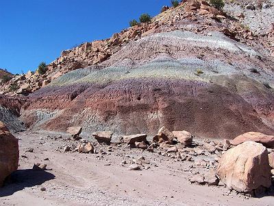
The Petrified Forest Member can be divided into the Lower Petrified Forest Member and Upper Petrified Forest Member in Arizona and New Mexico, separated by the Sonsela Sandstone. The Sonsela Sandstone is a braided-stream channel facies. The Petrified Forest grades into the Owl Rock Member. The Owl Rock is a marginal lacustrine to lacustrine facies possibly representing a large lake system. Finally, either the Rock Point or Church Rock Members overlie the Owl Rock. Some researchers feel the two Members may be synonymous. The two Members are complex heterolithic units, representing variously braided-river facies, lacustrine, and overbank deposits.
Ages of Chinle Members
The Chinle Formation is aged from early Late Triassic. Age correlation is based on Lucas's Land Vertebrate Faunachrons. The faunachrons are based on first and last appearances of phytosaurs. Simplified stratigraphy based on Litwin.
Subunits
Asterisks (*) indicate usage by the U.S. Geological Survey. Other usages by state geological surveys.
Group rank (alphabetical - rank and formations not recognized by the USGS)
Formation rank (alphabetical - several members not recognized by the USGS):
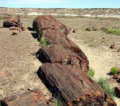
Places found
Geologic Province:
Parklands:
Other