
 | ||
River mouth Tujunga Wash, California | ||
Pacoima Wash, 33 miles (53 km) long, is a major tributary of the Tujunga Wash, itself a tributary of the Los Angeles River, in the San Fernando Valley of Los Angeles County, California.
Contents
Map of Pacoima Wash, California, USA
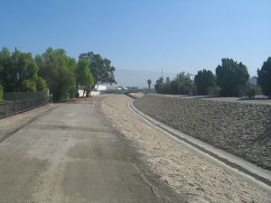
The stream begins at Mount Gleason, 6,502 ft (1,982 m), in the western San Gabriel Mountains of the Angeles National Forest. The upper reaches, sometimes known as Pacoima Creek, flow through Pacoima Canyon as a rapid mountain stream. It then reaches the Pacoima Dam Reservoir in the western San Gabriel Mountains of the Angeles National Forest and proceeds south in a free-flowing stream alongside Pacoima Trail Road. Below the dam, it is generally known as the Pacoima Wash. From there, it joins several other unnamed streams that drain the nearby mountains, collecting at Lopez Dam. South of that dam, Pacoima Wash is encased in a concrete flood control channel, and travels south from Kagel Canyon in Sylmar though San Fernando, Pacoima, Mission Hills, Panorama City, and Van Nuys.
Just after Interstate 5, the stream branches off to the Pacoima Diversion Channel, joining Tujunga Wash further upstream. Just before Raymer Street, the stream also branches off to an unnamed channel joining Tujunga Wash. The main Pacoima Wash continues to Van Nuys Boulevard and is carried through a storm drain to join Tujunga Wash further south.
Recent history
In 1991, the section between Lassen Street and Parthenia Street was one of the last sections of natural stream beds in the San Fernando Valley to be made a concrete channel.
In 2007, the wash was cleaned up after being cited as a fertile breeding ground for mosquitoes carrying the West Nile virus.
Pacoima Wash has been the site of several rescues of people, mostly of children and teenagers trapped in the spring runoff. Recent stories have appeared in 1985, 1993, 1995, 1996, 1998, and 2006.
In recent years there have been efforts to create a greenway along the Wash connecting the communities of the Northeast San Fernando Valley. In 2004 the Pacoima Wash Greenway Master Plan was created by Department of Landscape Architecture at Cal Poly Pomona which focuses on the portion of the Wash within the City of San Fernando.
In 2008 environmental non-profit Pacoima Beautiful started the Pacoima Wash initiative. The goal of this project is to create a linear greenway composed of bike lanes and a walking path along a 12 mile stretch of the Wash between the Pacoima Dam in Sylmar and the Tujunga Wash in Arleta. The Pacoima Wash Vision Plan, which covers the Sylmar and Pacoima portions of the Wash was produced in 2011. An addendum to the plan focusing on the Arleta portion of the Wash is currently being produced.
Several new parks along the Wash are in various stages of completion. 8th Street Park is a 4.75 acre park in the City of San Fernando which will be completed in spring of 2014. The city of Los Angeles is creating preliminary designs for a park along the Wash between El Dorado and Telfair Street.
Crossings and tributaries
From mouth to source (year built in parentheses):