
Country United States Opening date 1928 Opened 1929 Construction began 1925 | Status In use Type of dam arch Height 113 m Length 195 m Spillway 1 | |
 | ||
Similar Big Tujunga Dam, Cogswell Dam, Santa Anita Dam, Morris Dam, San Gabriel Dam | ||
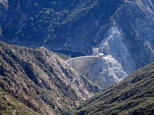
Pacoima Dam is a concrete arch dam on Pacoima Creek in the San Gabriel Mountains, in Los Angeles County, California. The reservoir which it creates, Pacoima Reservoir, has a capacity of 3,777 acre feet (4,659,000 m3)
Contents
Map of Pacoima Dam, California 91342, USA
Built by the Los Angeles County Flood Control District, which became part of the Department of Public Works, it was completed in 1928. At the time, the 371 foot (113m) high dam was the tallest arch dam in the U.S.
The dam is situated approximately 5 miles (8.0 km) northeast of Sylmar, above the San Fernando Valley.
InstrumentationEdit
As construction of Pacoima Dam began, the County of Los Angeles hired Roy W. Carlson as their concrete and soil testing engineer. He developed the world’s first strain meter which could be embedded in concrete. He also developed an adiabatic calorimeter and electrical-resistance thermometers to determine why the temperature of concrete increased during curing and how best to avoid cracking caused by these stresses.
Earthquake monitoringEdit
The Pacoima Dam withstood, but was damaged by the very strong ( >1 g ) ground movement which occurred during both the 1971 and 1994 earthquakes. Because of concerns about the stability of the dam and especially its response to potential future earthquakes, the County of Los Angeles, with the technical support of the USGS, began monitoring the dam using continuous GPS.