
- elevation 2,185 ft (666 m) Discharge 28.18 m³/s Length 557 km | - elevation 6,860 ft (2,091 m) - average 1,146 cu ft/s (32 m/s) Basin area 28,617 km² | |
 | ||
- max 29,000 cu ft/s (821 m/s) Cities | ||
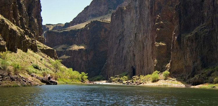
Owyhee river rafting
The Owyhee River is a tributary of the Snake River located in northern Nevada, southwestern Idaho and southeastern Oregon in the United States. It is 346 miles (557 km) long. The river's drainage basin is 11,049 square miles (28,620 km2) in area, one of the largest subbasins of the Columbia Basin. The mean annual discharge is 995 cubic feet per second (28.2 m3/s), with a maximum of 50,000 cu ft/s (1,400 m3/s) recorded in 1993 and a minimum of 42 cu ft/s (1.2 m3/s) in 1954.
Contents
- Owyhee river rafting
- Map of Owyhee River Oregon USA
- Snively hot springs on the owyhee river
- CourseEdit
- River modificationsEdit
- NamingEdit
- MiningEdit
- Death of Sacagaweas sonEdit
- Protected areasEdit
- References
Map of Owyhee River, Oregon, USA
The Owyhee drains a remote area of the arid plateau region on the north edge of the Great Basin, rising in northeastern Nevada and flowing generally northward near the Oregon-Idaho border to the Snake River. Its watershed is very sparsely populated. The Owyhee River and tributaries flow through the Owyhee Plateau, cutting deep canyons, often with vertical walls and in some places over 1,000 feet (300 m) deep.
Snively hot springs on the owyhee river
CourseEdit
The Owyhee River has its source in northeastern Nevada, in northern Elko County, approximately 50 miles (80 km) north of the city of Elko. It flows north along the east side of the Independence Mountains of Nevada, passing through Wild Horse Reservoir and then cutting northeast past the north end of the range. The river runs through the Humboldt National Forest, and then past the communities of Mountain City and Owyhee in the Duck Valley Indian Reservation. It then enters southwestern Idaho, flowing northwest for approximately 50 miles (80 km) across the southwest corner of the state through Owyhee County. It is then joined by the South Fork Owyhee River from the south, approximately 10 miles (16 km) east of the Oregon border. The main tributary of the South Fork is the Little Owyhee River.
The Owyhee River then enters extreme southeast Oregon in southern Malheur County, generally flowing north in a zigzag course west of the Idaho border. It merges with the West Little Owyhee River from the south, then receives the Middle Fork Owyhee River and North Fork Owyhee River from the east at a location known as "Three Forks". It then passes through the Owyhee Canyon between Big Grassy Mountain and Whitehouse Butte, then turns north, flowing east of Burns Junction and then west of Mahogany Mountain. In this area the Owyhee River receives the tributaries of Jordan Creek, Rattlesnake Creek, and Crooked Creek.
The Owyhee River enters the Snake River from the west on the Oregon–Idaho border approximately 5 miles (8 km) south of Nyssa, Oregon, and 2 miles (3 km) south of the mouth of the Boise River. The final stretch of the river, below Owyhee Dam, emerges from the Owyhee Plateau and enters the Snake River Plain.
River modificationsEdit
In northern Malheur County, approximately 20 miles (32 km) upstream from its mouth on the Snake, the Owyhee River is impounded by the Owyhee Dam, creating the serpentine Lake Owyhee, approximately 52 miles (84 km) long. The dam was constructed by the U.S. Bureau of Reclamation primarily to provide irrigation for the agricultural potato-growing region around the Snake River. Lake Owyhee State Park and scenic Leslie Gulch are along the eastern shore of the reservoir. Owyhee Dam was built in 1933 and eliminated anadromous fish such as salmon from the Owyhee River basin.
NamingEdit
The watershed of the river was part of region inhabited by the Shoshone and Bannock Indians. The name of the river is from the older spelling of "Hawaii". It was named for three Hawaiian trappers, in the employ of the North West Company, who were sent to explore the uncharted river. They failed to return to the rendezvous near the Boise River and were never seen again. Due to this the river and its region was named "Owyhee".
About one-third of the men with Donald MacKenzie's Snake Country Expeditions of 1819–20 were Hawaiians, commonly called "Kanakas" or "Sandwich Islanders" in those days, with "Owyhee" being a standard period spelling of the proper Hawaiian language name for the islands, hawai'i, which then was otherwise unused in English. The three Kanakas were detached to trap on the river in 1819 and were probably killed by Indians that year. It was not until the spring or early summer of 1820 that MacKenzie learned the news of their deaths (probably at the hands of men belonging to a band of Bannocks led by a chief named The Horse). Indians led other trappers to the site, but only one skeleton was located. The earliest surviving record of the name is found on a map dating to 1825, drawn by William Kittson (who was previously with Donald Mackenzie in 1819-1820, and then with Peter Skene Ogden in 1825), on which he notes "Owhyhee River" [his spelling]. Journal entries in 1826 by Peter Skene Ogden, a fur trapper who led subsequent Snake Country Expeditions for the Hudson's Bay Company refer to the river primarily as the "Sandwich Island River", but also as "S.I. River", "River Owyhee" and "Owyhee River."
MiningEdit
The discovery of gold and silver in the region in 1863 resulted in a temporary influx of miners and the establishment of mining camps, most of which have long since disappeared. The initial discovery was along Jordan Creek, and mining activity rapidly spread through the Owyhee watershed. This activity involved not only placer operations, but also underground mines and mills, resulting in a prolonged history of mining in the region. This invasion of Native American territory set off the 1864–68 Snake War.
Death of Sacagawea's sonEdit
In 1866 the son of Sacagawea, Jean Baptiste Charbonneau, died near Jordan Valley after catching a chill upon crossing the Owyhee en route from California to new gold strikes in Montana (one of the gold strikes, near Bannack, Montana, was interestingly just a few miles from where he had traveled as a toddler with his mother in the company of William Clark). After almost a century of neglect, his grave is now well marked, off Highway 95, near Danner at 42°57′07.1″N 117°20′21.4″W.
Protected areasEdit
In 1984, the United States Congress designated 120 miles (193 km) of the river as Owyhee Wild and Scenic River under the Wild and Scenic Rivers Act of 1968 to preserve the river in its free-flowing condition. Part of the designation includes the section of the river downstream from the Owyhee Dam, where the river flows through a remote section of deeply incised canyons surrounded by high canyon rims that are habitat for mountain lion, bobcat, Mule Deer, California Bighorn Sheep, and a large variety of raptors.
The Omnibus Public Land Management Act of 2009 designated 323,274 acres (130,824 ha) on and around the Owyhee River in Idaho as wilderness. The bill was signed into law by President Barack Obama on March 30, 2009. The new wilderness areas are: