
Elevation 10,438 ft (3,182 m) | Highest point McAfee Peak | |
 | ||
Length 70 mi (110 km) North-South | ||
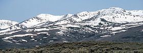
The Independence Mountains are a mountain range in northern Elko County, Nevada, United States. The range reaches a maximum elevation of 10,439 ft (3,182 m) on the summit of McAfee Peak. The range extends northward approximately 70 mi (110 km) from a point near Carlin to the banks of the Owyhee River. To the east is the North Fork of the Humboldt River, and to the west is the Owyhee Desert. Passing to the south is the main branch of the Humboldt River, and near the northern end of the range is the Wild Horse State Recreation Area. The Owyhee River is tributary to the Snake-Columbia system, while the Humboldt is within the Great Basin.
From a point about seven miles north of Carlin, the range rises to Swales Mountain, at an elevation of 8,068 ft (2,459 m). Dropping to an area of hills and buttes, it then rises again to Lone Mountain (Nannies Peak), at 8,780 ft (2,680 m). The range then drops nearly to the level of the surrounding valleys, at a pass where State Route 226 connects to the community of Tuscarora.
Rising sharply to the main core of the range, the crest runs through Wheeler Mountain (9,057 ft (2,761 m)), Jack's Peak (10,198 ft (3,108 m)), and finally to the range high point, McAfee Peak.
Most of the range north of State Route 226 is included within the Mountain City Ranger District of the Humboldt-Toiyabe National Forest.