
Municipality Gáivuotna–Kåfjord Area 46 ha Population 299 (2013) | Elevation 8 m (26 ft) Local time Friday 12:02 AM | |
 | ||
Weather -1°C, Wind W at 16 km/h, 69% Humidity | ||
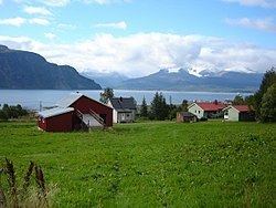
Olderdalen (Northern Sami: Dálošvággi; Kven: Junttaniemi) is the administrative centre of the municipality of Gáivuotna–Kåfjord in Troms county, Norway. Olderdalen is located in the Olderdalen valley along the Kåfjorden with a view of the Lyngen Alps, and has a ferry connection to Lyngseidet, the administrative centre of Lyngen, across the fjord. European route E6 passes through this village also.
Contents
Map of 9146 Olderdalen, Norway
Olderdalen is located about 16.7 km (10.4 mi) to the northwest of the village of Birtavarre and it is about 70 km (43 mi) to the east of Tromsø. The 0.46-square-kilometre (110-acre) village has a population (2013) of 299, which gives the village a population density of 650 inhabitants per square kilometre (1,700/sq mi). Kåfjord Church is located in this village.
Economy
The Olderdalen area is home to mainly farming and fishing. Raising sheep and dairy cattle are two of the most prominent types of agriculture in the area. There is also grocery services as well as public and private services.
History
During World War II many of the houses and farms in Olderdalen fell victim of the German scorched earth tactics when they withdrew from Finland and Finnmark. This led to much of the infrastructure and buildings in the village being destroyed to prevent the invading Soviet forces from obtaining supplies.