
Existed: 1969 – present Constructed 1969 | Length 37 km | |
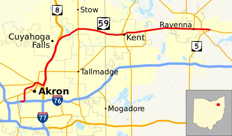 | ||
State Route 59 (SR 59) is an east–west state highway in the northeastern portion of Ohio, a U.S. state. The western terminus of State Route 59 is in downtown Akron at a partial interchange with the Interstate 76/Interstate 77 concurrency. The eastern terminus of the state route is at State Route 5 just 0.5 miles (0.80 km) east of the Ravenna city limits.
Contents
Route description
State Route 59 traverses parts of Summit and Portage Counties. The portion of State Route 59 beginning at the northern interchange with the State Route 8 freeway, and heading east through Kent and Ravenna to the State Route 5 junction is included within the National Highway System, a network of routes deemed most important for the economy, mobility and defense of the nation.
Haymaker Parkway
Haymaker Parkway is the name given to the rerouted section of State Route 59 than runs through Kent, Ohio as a bypass road. It is a five-lane road with two bridges built between 1968 and 1975. The largest of the two bridges, the Redmond Greer Memorial Bridge, [1] passes over both sets of railroad tracks that pass through downtown Kent (known locally as the "upper" and "lower" tracks) as well as Franklin Avenue, the Cuyahoga River, and Franklin Mills Riveredge Park. The Greer bridge also carries SR 43 during its short co-sign with SR 59 in between South Mantua Street (SR 43 South) and River Street (SR 43 North), and South Water Street. The parkway's eastern terminus is at the intersection of East Main and Willow Streets and its western terminus is at the intersection of West Main Street and Longmere Drive. For much of its route it parallels (and actually bisects) Stow Street. It is named for the Haymaker family who, in December 1805, became the first family to settle Franklin Township and what would become Kent. The parkway was built mainly to provide bridges over all of Kent's railroad crossings for public safety vehicles as well as to relieve congestion in the downtown area. Several homes were razed in order to build the parkway, particularly many along Stow Street and in the neighborhood between Kent State University and downtown Kent along East Erie Street and East College Avenue.
History
State Route 59 was certified in 1969. The general route was originally designated as State Route 36 until 1932 and as State Route 5 from 1932 to 1969; however, State Route 5 now takes a turn south on an expressway southeast of Ravenna towards I-76 rather than heading west to Cuyahoga Falls and Akron. The route is a freeway in its shared portion with State Route 8 southward from Front Street in Cuyahoga Falls. State Route 59 is signposted as following Perkins Avenue westward from State Route 8, where, at Howard Street, it becomes the freeway officially known as the Martin Luther King Jr. Freeway, more commonly referred to as the Innerbelt. (Until August 17, 2007, this routing was identified in Ohio DOT records as State Route 59T, whereas State Route 59 in the records continued south along State Route 8 and ended at the Market Street/State Route 18 underpass.) The rest of the route is formed by regular roads, with the exception of the Haymaker Parkway in Kent, which is a bypass with cross streets.
The section of the route that runs through Stow and Kent was widened sometime in the 1980s. The section in Cuyahoga Falls from the State Route 8 to near Victor St. was widened in 2004 to meet state requirements due to high traffic levels.
The prior alignment of State Route 59 is primarily followed by the current State Route 113.
The Innerbelt
The Innerbelt portion of State Route 59 in Akron is not well utilized. Designed after almost all other highway projects in Akron were completed, the Innerbelt was envisioned as a 21.5-mile (34.6 km) stretch; however the only portion that was ever built was a 2.24-mile (3.60 km) stretch near Akron’s downtown. The freeway is designed with 6 lanes (with right of way for eight). It includes two collector streets along the entire corridor which, combined, are at some points as wide as the freeway itself. The interchages are long, at some points crossing each other, so that additional overpasses are required for the ramps . The ramps connecting it to Interstate 76/Interstate 77, opened October 8, 1986, more than a decade after most of the rest of the highway opened, only turn to the west, so traffic can only enter the Innerbelt if traveling east on the interstate and from the Innerbelt, vehicles can only exit west onto the interstate. While the Ohio Department of Transportation (ODOT) is currently evaluating changing this design, for now drivers need to take regular roads to make the connection. This was a financial concession when the southernmost part of the Innerbelt was built. The connection to the Northern Freeway (State Route 8) was never made, and a temporary link with Martin Luther King Blvd./Perkins St. became permanent.
Shortly after the connection to Interstate 76/Interstate 77 opened, it became clear that the Innerbelt would not live up to expectations; those not served by the western ramps were not very willing to travel over five blocks of marginal roads to connect to a 2.24-mile (3.60 km) freeway. However, the Innerbelt’s underuse has given it an advantage few planners had foreseen. In July 2001, the city announced that the Innerbelt would be closed for several days while a commercial was being shot. The highway was also surveyed by the producers of the movie Matrix Reloaded, as a possible shooting spot of the highway scene. Peter Novak, the Matrix's location scout said that "They were looking at finding a practical freeway to film the car chase on, which was going to be about 6 to 7 weeks of shutting down a major freeway. It was originally thought that they needed 4 to 5 miles of super highway in both directions. We sent scouts out around the world: we had people looking around Kuala Lumpur, people looking at Bangkok, people looking at the autobahn in Germany, and I personally looked through the northern United States. I don’t think we left a stone unturned, and we wound up with a freeway in Akron..." The idea was eventually scrapped, because in the event that the scene would have to be reshot, the time to reset all the cars in their start position would take too long.
In 1999 Akron mayor Don Plusquellic suggested ripping up the northern end of the freeway, making it a city street, and developing the surrounding land. The idea was fostered by a trip to Milwaukee, in which Plusquellic saw the much-maligned Park East Freeway spur in that city's downtown removed in order to reuse the land. A similar plan presented in late 2014 proposed removal of the freeway north of the West Exchange Street overpass with an upgrade of the adjacent frontage roads to compensate. Construction relating to this plan started in early 2017.