
Existed: 1962 – present Length 294 km | Constructed 1962 | |
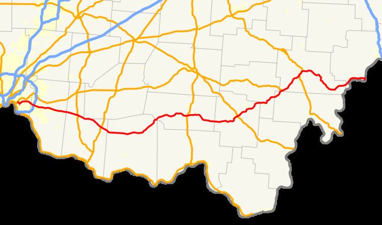 | ||
State Route 32, also known as SR 32 and the James A. Rhodes Appalachian Highway, is a major east–west highway across the southern portion of the U.S. state of Ohio. It is the eighth longest state route in Ohio. It leads from eastern Cincinnati, near the border between the neighborhoods of Linwood, Mount Lookout, and Columbia-Tusculum, to the Parkersburg-Belpre Bridge across the Ohio River in Belpre.
Contents
Except in Belpre, leading up to the bridge into West Virginia, the entire route outside Cincinnati's beltway (Interstate 275) is a high-speed four-lane divided highway, forming the Ohio portion of Corridor D of the Appalachian Development Highway System. This corridor continues east across the Ohio River over the Blennerhassett Island Bridge.
History
The Batavia Turnpike and Miami Bridge Company was incorporated and chartered by the state of Ohio. It built a road, which was "about finished" as of 1841, beginning at the Wooster Turnpike (Eastern Avenue), crossing the Little Miami River on the Union Bridge, and turning east to Batavia. The Ohio Turnpike to Bethel split after the Little Miami was crossed.
The passage of the McGuire Bill in 1911 led to the designation of a large number of Inter-County Highways to be maintained by the Ohio Department of Highways. This network included the Cincinnati-Batavia Road (ICH 41) and Batavia-Winchester Road (ICH 125), connecting Cincinnati to Batavia, Williamsburg, Mt. Orab, Sardinia, Winchester, and beyond to an intersection with the West Union-Belfast Road (ICH 122) south of Seaman (where Graces Run Road now meets State Route 247). This entire route from Cincinnati to south of Seaman was designated and signed as State Route 74 in 1923. The route left downtown Cincinnati on Eastern Avenue, shared with State Route 7 (now U.S. Route 52) and State Route 25 (now State Route 125). SR 7 left at Davis Lane (now Airport Road), while SR 25 and SR 74 turned onto Beechmont Avenue, splitting after crossing the Little Miami River. By 1925, the east end of SR 74 had been realigned and extended, heading east from Winchester through Seaman and continuing through Peebles to State Route 73 northwest of Rarden; the old alignment (Graces Run Road) reverted to local control. Along with U.S. Route 50, US 52, and SR 125, SR 74 was moved to Columbia Parkway in the early 1940s, and in the early 1950s it was removed from downtown Cincinnati to its present terminus. Due to the existence of Interstate 74 west of Cincinnati, the number was changed to State Route 32 in 1962, with SR 74 signs being removed in June 1963 after a period of dual signage.
The state relocated the road between Mount Carmel and Batavia as a four-lane divided highway in the early 1960s, several years after the parallel State Route 125 was widened (but not realigned). Because this was done before or during the renumbering, the old road here is known as Old State Route 74, rather than Old State Route 32 to the east. Improvement of the rest of the road did not take place until after it was added to the Appalachian Development Highway System in 1965. This proposed Appalachian Highway—part of Corridor D—was to run across the southern part of the state from Interstate 275 outside Cincinnati to Belpre. From the east end of SR 32 east of Peebles, the route was to continue northeast, joining State Route 772 near Elmgrove, and following State Route 124 beyond Jackson to Roads. After continuing northeast to Radcliff, it would parallel State Route 346 and a portion of State Route 143, merging with U.S. Route 50 west of Albany and following it past Athens and Coolville to Belpre. A never-built branch, planned as part of Corridor B, would have followed State Route 73 and State Route 348 from east of Peebles to Lucasville on U.S. Route 23 (Corridor C).
Future
The portion of Route 32 in Clermont, Brown, Highland, Adams, and Pike counties is under consideration as the eastward continuation of Interstate 74 from Cincinnati to Piketon, where it would connect with Interstate 73. This would necessitate replacing at-grade crossings (many of which currently have traffic signals) with either limited access interchanges or totally eliminating access.