
Existed: 1926 – present Constructed 1926 | Length 55.64 km | |
 | ||
Counties | ||
State Route 25 (SR 25) is an Ohio state route that runs between Cygnet and Toledo in the US state of Ohio. The highway has a total length of 34.98 miles (56.29 km). Some of the highway is listed on the National Highway System and various sections are rural four-lane-lane highways and urbanized four-lane divided highways. SR 25 passes through farmland, commercial and residential properties.
Contents
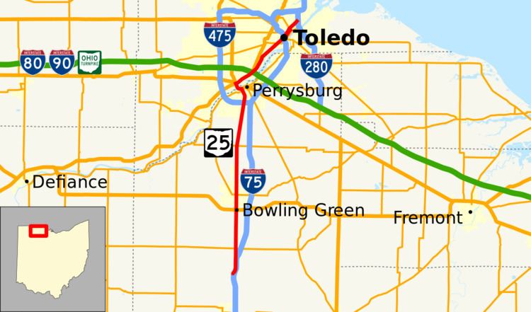
Map of OH-25, Ohio, USA
Between Cygnet and Perrysburg it is the relic of an old U.S. Route 25 (US 25) that passes through Bowling Green as largely a divided surface highway. From Perrysburg it crosses the Maumee-Perrysburg Bridge joint with US 20 and then follows the Anthony Wayne Trail from Maumee into downtown Toledo. The Maumee portion is joint with US 24. (US 24 in greater Toledo takes, as far south as Perrysburg, the path of what used to be U.S. Route 25, more distant from the newer Interstate 75 (I-75), having had its route switched with that of old U.S. Route 25). North of this former terminus, SR 25 runs through downtown Toledo on Erie Street (northbound) and Michigan Street (southbound) before becoming the Greenbelt Parkway, which is cut off at I-280, terminating the route.
Route description
SR 25 heads west from its southern terminus at an interchange with I–75 in rural Wood County. The highway heads west, before turning north at an intersection with Cygnet Road (Township Highway 3). The highway heads northeast passing through farmland as a two-lane highway closely paralleling I–75. The route turns due north and becomes a four-lane divided highway, still closely paralleling I–75, before I–75 heads northeast. The road has an intersection with SR 281 and then begins to enter residential properties. The highway enters Bowling Green at an interchange with U.S. Route 6 (US 6) and passes through commercial properties.
At a traffic signal with Gypsy Lane Road the highway becomes a four-lane highway with a center left-turn lane until a traffic signal at Napoleon Road when the roadway loses the left turn lane. North of Napoleon Road the highway passes through residential properties, until the road enters downtown Bowling Green. The highway passes through the downtown business district of Bowling Green and an intersection with SR 64. The road leaves downtown Bowling Green and returns to passing through residential properties. At Poe Road, SR 25 passes through commercial properties before leaving Bowling Green. North of Bowling Green the route passes through rural farmland as a rural four-lane undivided highway. The highway has a traffic signal at SR 582 and becomes a four-lane divided highway heading northeast passing through farmland with some houses.
SR 25 enters Perrysburg passing through commercial properties and having an interchange with Interstate 475 (I–475) and US 23. At Findlay Street the highway curves northeast and becomes a four-lane undivided highway, passing through commercial and residential properties. The road crosses over a set of railroad tracks, before an intersection with SR 65. SR 65 heads northwest concurrent with SR 25 and the concurrency has an intersection with US 20. At the intersection with US 20, SR 65 turns east onto US 20 and SR 25 turns northwest onto US 20. The concurrency heads northwest concurrent as a four-lane undivided highway passing through woodland and crossing over the Maumee River. The concurrency enters Maumee and has an intersection with US 24 and SR 25 turns northeast, concurrent with US 24.
The concurrency with US 24 heads northeast as a four-lane divided highway passing through mostly residential properties. The highway has a bridge over the Ohio Turnpike. On that bridge is an intersection with Detroit Avenue. US 24 leaves SR 25 and heads north-northeast on Detroit. North of the Turnpike the highway enters Toledo and passes through woodland, with some houses and Toledo Country Club, before returning to residential properties. At Woodsdale Avenue the route passes through the Toledo Zoo and under a set of railroad tracks. Northeast of the tracks the road enters a wooded area with some commercial properties. The highway has an incomplete interchange with Collingwood Boulevard - the interchange is a northbound exit and southbound entrance on SR 25. This interchange allows northbound SR 25 to have access to southbound I–75 and northbound I–75 access to southbound SR 25. The highway has an interchange with I–75 - this interchange is also incomplete allowing only southbound to southbound or northbound to northbound movements.
SR 25 enters downtown Toledo and the highway becomes one-way streets, with northbound on Erie Street and southbound on Michigan Street. The two streets are two blocks apart and the Lucas County Court House is between them. At the northeast corner of the court house northbound SR 25 turns northwest and meets southbound SR 25. At this intersection the one-way streets end and SR 25 heads northwest on Cherry Street as a four-lane undivided roadway. The route has an intersection with SR 120 and, after a turn to the northeast, the route becomes a four-lane divided highway. Northeast of SR 120 the highway passes through woodland and industrial properties. The northern terminus of SR 25 is at an interchange with I–280, with the roadway continuing northeast. The Parkway ends northeast of the interchange at Galena Street in a wooded area near the Toledo Correctional Institute.
The portion of SR 25 running from the I-475/US 23 diamond interchange in Perrysburg to the I-75 interchange near downtown Toledo is included within the National Highway System. A 2009 traffic report from the Ohio Department of Transportationt showed that the lowest traffic levels were the 5,287 vehicles used the highway daily on the section near its southern terminus, between I–75 and SR 281 in Wood County, while peak traffic volumes were 61,648 vehicles along a section of SR 25 between SR 120 and I–280.
History
Most of the route was at one time the Dixie Highway.
In 1923 the route at later became SR 25 was signed as SR 6. The SR 6 designation was changed to US 25 on November 11, 1926. Between 1946 and 1948 the roadway was widen to a four-lane divided highway, between Bowling Green and Maumee. With the section south of Bowling Green being widen to a four-lane divided highway between 1951 and 1953. US 25 was decommissioned in 1973 and SR 25 was signed along most of its route. Between 1987 and 1989, SR 25 and US 24 switched routes north of the intersection at Detroit Avenue. Between 1997 and 1999 the road from the second interchange with I–75 and I–280 was widen into a four-lane divided highway.
In 2004, a 5-mile stretch of SR 25 in Wood County won a Perpetual Pavement Award from the Asphalt Pavement Association. The section was originally constructed in between 1937 and 1940 as one of the first "deep-strength" asphalt pavements built in Ohio.