
Existed: 1924 – present Constructed 1924 | Length 129.6 km | |
 | ||
West end: US 6 / US 20 / US 42 / US 322 / US 422 / SR 3 / SR 8 / SR 43 / SR 87 in Cleveland Counties Cuyahoga County, Ohio, Summit County, Ohio, Portage County, Ohio, Mahoning County, Ohio, Columbiana County, Ohio | ||
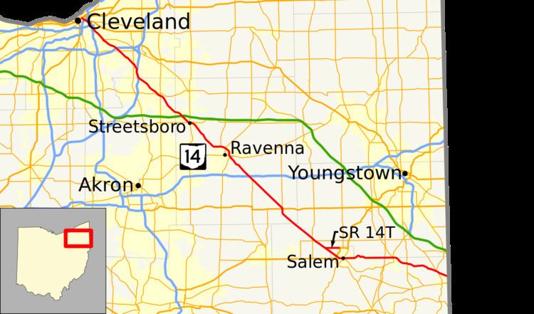
State Route 14, located in northeastern Ohio, runs from U.S. Route 6/U.S. Route 42/State Route 3 in Downtown Cleveland southeasterly to the Pennsylvania state line near East Palestine; Pennsylvania Route 51 continues southeasterly from there.
Contents
History
Route 14 Temporary
State Route 14 Temporary (SR 14T) is a 2.73-mile-long bypass around the city of Salem. SR 14T, a four-lane highway, begins at SR 14, Cleveland – East Liverpool Road, in Mahoning County. SR 14T crosses into Columbiana County and passes under County Route 61 and Goshen Road. SR 14T then has a diamond interchange with US 62 and SR 45. Exit ramps provide access from SR 14T to US 62 west and SR 45 south, and the two highways merge onto the SR 14T right-of-way as it continues past its terminus.
Although the SR 14T designation is unsigned, signs on the road read "TO US 62 / SR 45". The entire route is built to freeway standards with a speed limit of 65 miles per hour (105 km/h).
The entire route is in Salem. All exits are unnumbered.
Route 14 Alternate
State Route 14A existed from 1951 to 1984 and followed what has been State Route 14 outside of that period between US 224 and SR 46 (see History section).