Samiksha Jaiswal (Editor)

Ohio State Route 124

Updated on
Edit
Like
Comment
Share on FacebookTweet on TwitterShare on LinkedInShare on Reddit
Existed:
  
1926 – present

Constructed
  
1926

Length
  
266.4 km

Ohio State Route 124

West end:
  
SR 134 near Martinsville

East end:
  
US 50 / SR 7 / SR 32 near Torch

Counties
  
Clinton County, Ohio, Highland County, Ohio

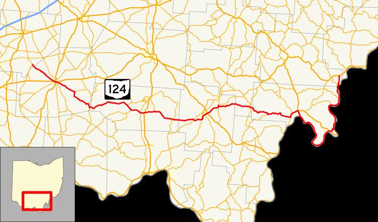
State Route 124 (SR 124) is an east–west state highway in the southern portion of the U.S. state of Ohio. Its western terminus is at State Route 134 nearly 4 miles (6.4 km) southeast of Martinsville, and its eastern terminus is near the unincorporated village of Torch at the concurrency of U.S. Route 50, State Route 7, and State Route 32 in extreme southeastern Athens County. The road passes through numerous villages along its route, many of them economically depressed. State Route 124 has the longest concurrency of state routes in Ohio, running concurrent with State Route 32 for 35½ miles. The road was recently rerouted in 2003 following the extension of U.S. Route 33 to the Ravenswood Bridge.

Contents

Map of OH-124, Ohio, USA

History

  • 1926 – Original route certified; originally routed from Hillsboro to 3 miles (4.8 km) south of Portland along the former State Route 24 alignment.
  • 1934 – Extended to Portland.
  • 1935 – Extended to 1-mile (1.6 km) east of Coolville along a previously unnumbered road from Portland to Long Bottom, a former alignment of State Route 248 from Long Bottom to Reedsville, a previously unnumbered road from Reedsville to Hockingport, and along the current State Route 144 from Hockingport to 1-mile (1.6 km) east of Coolville.
  • 1936 – Rerouted to its current eastern terminus along a previously unnumbered road (this alignment was State Route 144 before 1926); Hockingport to 1-mile (1.6 km) east of Coolville certified as State Route 144.
  • 1938 – Extended to its current western terminus along a previously unnumbered road; rerouted from Great Bend to 3 miles (4.8 km) south of Portland along the current State Route 338; former alignment from Great Bend to 3 miles (4.8 km) south of Portland certified as State Route 338.
  • 1941 – State Route 124 and State Route 338 alignments from Great Bend to 3 miles (4.8 km) south of Portland reverted to previous and current routings.
  • 1934 – Extended to Portland.
  • 1969 – Joined with State Route 7 along Pomeroy bypass.
  • 1974 – 4 miles (6.4 km) west of Jasper to Jasper upgraded to divided highway.
  • 1984 – Joined by State Route 32 from 4 miles (6.4 km) west of Jasper to Roads.
  • unknown – Givens to Roads upgraded to divided highway.
  • 1997 – Jasper to Givens upgraded to divided highway.
  • 2003 – Routed along the former U.S. Route 33 alignment from 2 miles (3.2 km) north of Pomeroy to 1-mile (1.6 km) east of Pomeroy; routed along a former alignment of State Route 338 from Racine to Great Bend; former State Route 124 alignment from Racine to Great Bend decertified.
  • 2009 - Routed along Athens County Road 62 (Youba Ridge Rd.) from Hockingport to a new eastern terminus near Torch. The former section from Hockingport to Little Hocking had been permanently closed in 2005 due to a landslide.
  • Before 1926

  • 1924 – Original route established; originally routed from Sharonville to Franklin.
  • 1926 – Entire route became a portion of the former U.S. Route 25.
  • References

    Ohio State Route 124 Wikipedia