
Length 1,200 km Discharge 4,706 m³/s | Basin area 223,856 km² Source Batéké Plateau | |
 | ||
Basin size 223,856 km (86,431 sq mi) | ||
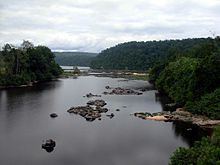
The Ogooué (or Ogowe), some 1,200 kilometres (700 mi) long, is the principal river of Gabon in west central Africa and the fourth largest river in Africa by volume of discharge, trailing only the Congo, Niger and Zambezi. Its watershed drains nearly the entire country of Gabon, with some tributaries reaching into the Republic of the Congo, Cameroon, and Equatorial Guinea.
Contents
Map of Ogooue River
Course
The Ogooué River rises in the northwest of the Bateke Plateaux near Kengue, Republic of Congo. It runs northwest, and enters Gabon near Boumango. Poubara Falls are near Maulongo. From Lastoursville until Ndjole, the Ogooué is non-navigable due to rapids. From the latter city, it runs west, and enters the Gulf of Guinea near Ozouri, south of Port Gentil. The Ogowe Delta is quite large, about 100 km long and 100 km wide.
Basin
The Ogooué Basin is 223,856 square kilometres (86,000 sq mi), of which 173,000 square kilometres (67,000 sq mi) or 73 percent lies within Gabon. It mostly consists of undisturbed rainforest with some savanna grassland where the mid-year dry season is longest. It is home to a high biodiversity. All three species of African crocodile, for instance, occur in the river: the Nile crocodile, the dwarf crocodile, and the slender-snouted crocodile. It is also the type locality for the catfish Synodontis acanthoperca.
The Mpassa River is a tributary of the Ogooué River. The Ndjoumou River is the main tributary of Mpassa River.
Economy
The Ogooué is navigable from Ndjole to the sea. It is used to bring wood to the Port Gentil Harbour.
The Ogowe Basin includes several major conservation reverves, notably Lope National Park.
The catchment area has an average population density of 4 people per km². Towns along the river include Ayem, Adané, Loanda, Lambaréné, Ndjole, Booué, Kankan, Maulongo, Mboungou-Mbadouma, Ndoro, Lastoursville, Moanda, and Franceville near the Congo border.
Towns in Congo include Zanaga.
The first European explorer, Pierre Savorgnan de Brazza, traveled in the area in the 1870s. Persistent reports by the natives of creatures resembling dinosaurs have motivated a number of recent expeditions into the area of the northern tributaries of the Ogooué and the swamps on the western side of the Congo River.
Tributaries
The Ogowe River receives water of numerous tributaries including: