
Existed: 1934 – present Constructed 1934 | Length 55.8 km | |
 | ||
Counties | ||
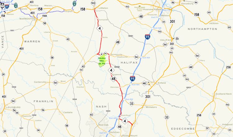
North Carolina Highway 4 (NC 4) is a North Carolina state highway that is 35 miles (56 km) in length. Running near the Virginia border in Nash and Halifax counties, NC 4 connects the region with Interstate 95 (I-95).
Contents
Map of NC-4, North Carolina, USA
Route description
The southern terminus of NC 4 is at U.S. Route 301 (US 301) near Rocky Mount. After heading west, NC 4 joins NC 48 near I-95 with exit/entrance ramps (exit 145); numerous hotels can be found here, built especially for I-95 travelers. After heading north for about 15 miles (24 km), NC 4 splits from NC 48 and joins NC 561 near Medoc Mountain State Park, heading west. After several miles, the road splits off and heads north for about 12 miles (19 km) before entering Littleton and ending at US 158/NC 903 downtown.
NC 4 is one of the more rural roads in this part of the state; before entering Littleton, there are no incorporated towns along the route. This section of the state is mainly farmland.
History
As North Carolina renumbered its state highways in 1934, NC 4 was commissioned as a short state highway, running only a few miles from US 158 to the community of Airlie, just south of Littleton. When NC 48 running from Airlie to Littleton is rerouted to the east in 1951, NC 4 was left to take its place. In 1984 NC 4 was extended southward, taking over parts of NC 561, NC 48, and the decommissioned I-95 Business to US 301. I-95 Business was intended to take traffic from US 301 to I-95, and NC 4 took over that role.