
 | ||
The New Madrid Seismic Zone (pronounced /nuː ˈmædrɪd/), sometimes called the New Madrid Fault Line, is a major seismic zone and a prolific source of intraplate earthquakes (earthquakes within a tectonic plate) in the Southern and Midwestern United States, stretching to the southwest from New Madrid, Missouri.
Contents
- Map of New Madrid Seismic Zone New Madrid Township MO 63869 USA
- Location
- Earthquake history
- Prehistoric earthquakes
- December 25 1699
- 181112 earthquake series
- Modern activity
- Geology
- Potential for future earthquakes
- Iben Brownings 1990 prediction
- Uncertainty over potential for recurrence
- References
Map of New Madrid Seismic Zone, New Madrid Township, MO 63869, USA
The New Madrid fault system was responsible for the 1811–12 New Madrid earthquakes and may have the potential to produce large earthquakes in the future. Since 1812, frequent smaller earthquakes have been recorded in the area.
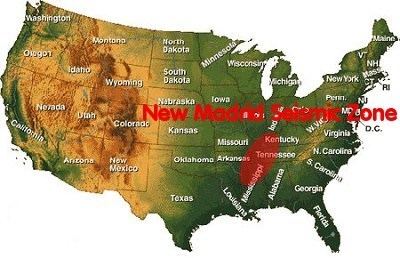
Earthquakes that occur in the New Madrid Seismic Zone potentially threaten parts of eight American states: Illinois, Indiana, Missouri, Arkansas, Kentucky, Tennessee, Oklahoma and Mississippi.
Location
The 150-mile (240 km) long seismic zone, which extends into five states, stretches southward from Cairo, Illinois; through Hayti, Caruthersville and New Madrid in Missouri; through Blytheville into Marked Tree in Arkansas. It also covers a part of West Tennessee, near Reelfoot Lake, extending southeast into Dyersburg. It is southwest of the Wabash Valley Seismic Zone.
Most of the seismicity is located between 3 and 15 miles (4.8 and 24.1 km) beneath the Earth's surface.
Earthquake history
The zone had four of the largest North American earthquakes in recorded history, with moment magnitudes estimated to be as large as 7.0 or greater, all occurring within a three-month period between December 1811 and February 1812. Many of the published accounts describe the cumulative effects of all the earthquakes (known as the New Madrid Sequence); thus finding the individual effects of each quake can be difficult. Magnitude estimates and epicenters are based on interpretations of historical accounts and may vary.
Prehistoric earthquakes
Because uplift rates associated with large New Madrid earthquakes could not have occurred continuously over geological timescales without dramatically altering the local topography, studies have concluded that the seismic activity there cannot have gone on for longer than 64,000 years, making the New Madrid Seismic Zone (NMSZ) a young feature, or that earthquakes and the associated uplift migrate around the area over time, or that the NMSZ has short periods of activity interspersed with long periods of quiet. Archaeological studies have found from studies of sand blows and soil horizons that previous series of very large earthquakes have occurred in the NMSZ in recent prehistory. Based on artifacts found buried by sand blow deposits and from carbon-14 studies, previous large earthquakes like those of 1811–1812 appear to have happened around AD 1450 and around AD 900, as well as approximately AD 300. Evidence has also been found for an apparent series of large earthquakes around 2350 BC. About 80 km southwest of the presently-defined NMSZ but close enough to be associated with the Reelfoot rift, near Marianna, Arkansas, two sets of liquefaction features indicative of large earthquakes have been tentatively identified and dated to 3500 BC and 4800 BC. These features were interpreted to have been caused by groups of large earthquakes timed closely together.
Dendrochronology (tree ring) studies conducted on the oldest bald cypress trees growing in Reelfoot Lake found evidence of the 1811–1812 series in the form of fractures followed by rapid growth after their inundation, whereas cores taken from old bald cypress trees in the St. Francis sunklands showed slowed growth in the half century that followed 1812. These were interpreted as clear signals of the 1811–1812 earthquake series in tree rings. Because the tree ring record in Reelfoot Lake and the St. Francis sunk lands extend back to AD 1682 and AD 1321, respectively, Van Arsdale et al. interpreted the lack of similar signals elsewhere in the chronology as evidence against large New Madrid earthquakes between those years and 1811.
December 25, 1699
The first known written record of an earthquake felt in the NMSZ was from a French missionary traveling up the Mississippi with a party of explorers. At 1 p.m., on Christmas Day 1699, at a site near the present-day location of Memphis, the party was startled by a short period of ground shaking.
1811–12 earthquake series
The earthquakes were felt as far away as New York City and Boston, where ground motion caused church bells to ring.
Hundreds of aftershocks followed over a period of several years. Aftershocks strong enough to be felt occurred until the year 1817. The largest earthquakes to have occurred since then were on January 4, 1843, and October 31, 1895, with magnitude estimates of 6.0 and 6.6 respectively.
Modern activity
The biggest quake since 1811–12 was a 6.6-magnitude quake on October 31, 1895, with an epicenter at Charleston, Missouri. The quake damaged virtually all buildings in Charleston, created sand volcanoes by the city, cracked a pier on the Cairo Rail Bridge and toppled chimneys in St. Louis, Missouri; Memphis, Tennessee; Gadsden, Alabama; and Evansville, Indiana.
The next biggest quake in the New Madrid Seismic Zone was a 5.4-magnitude quake (although it was reported as a 5.5 at the time) on November 9, 1968, near Dale, Illinois. The quake damaged the civic building at Henderson, Kentucky and was felt in 23 states. People in Boston said their buildings swayed. At the time of the quake, it was the biggest recorded quake with an epicenter in Illinois in that state's recorded history. In 2008 in the nearby Wabash Valley Seismic Zone, a similar magnitude 5.4 earthquake occurred with its epicenter in Illinois near West Salem and Mount Carmel.
Instruments were installed in and around the area in 1974 to closely monitor seismic activity. Since then, more than 4,000 earthquakes have been recorded, most of which were too small to be felt. On average, one earthquake per year is large enough to be felt in the area.
Geology
The faults responsible for the New Madrid Seismic Zone are embedded in a subsurface geological feature known as the Reelfoot Rift that formed during the breakup of the supercontinent Rodinia in the Neoproterozoic Era (about 750 million years ago). The resulting rift system failed to split the continent, but has remained as an aulacogen (a scar or zone of weakness) deep underground, and its ancient faults appear to have made the Earth's crust in the New Madrid area mechanically weaker than much of the rest of North America.
This relative weakness is important, because it would allow the relatively small east-west compressive forces associated with the continuing continental drift of the North American plate to reactivate old faults around New Madrid, making the area unusually prone to earthquakes in spite of it being far from the nearest tectonic plate boundary.
Since other ancient rifts are known to occur in North America but not all are associated with modern earthquakes, other processes could be at work to locally increase mechanical stress on the New Madrid faults. It has also been suggested that some form of heating in the lithosphere below the area may be making deep rocks more plastic, which would concentrate compressive stress in the shallower subsurface area where the faulting occurs.
Potential for future earthquakes
In a report filed in November 2008, the U.S. Federal Emergency Management Agency warned that a serious earthquake in the New Madrid Seismic Zone could result in "the highest economic losses due to a natural disaster in the United States," further predicting "widespread and catastrophic" damage across Alabama, Arkansas, Illinois, Indiana, Kansas, Kentucky, Mississippi, Missouri, Oklahoma, Texas, and particularly Tennessee, where a 7.7 magnitude quake or greater would cause damage to tens of thousands of structures affecting water distribution, transportation systems, and other vital infrastructure. The earthquake is expected to also result in many thousands of fatalities, with more than 4,000 of the fatalities expected in Memphis alone.
The potential for the recurrence of large earthquakes and their impact today on densely populated cities in and around the seismic zone has generated much research devoted to understanding in the New Madrid Seismic Zone. By studying evidence of past quakes and closely monitoring ground motion and current earthquake activity, scientists attempt to understand their causes and recurrence intervals.
In October 2009, a team composed of University of Illinois and Virginia Tech researchers headed by Amr S. Elnashai, funded by the Federal Emergency Management Agency (FEMA), considered a scenario where all three segments of the New Madrid fault ruptured simultaneously with a total earthquake magnitude of 7.7. The report found that there would be significant damage in the eight states studied – Alabama, Arkansas, Illinois, Indiana, Kentucky, Mississippi, Missouri, and Tennessee – with the probability of additional damage in states farther from the NMSZ. Tennessee, Arkansas, and Missouri would be most severely impacted, and the cities of Memphis, Tennessee and St. Louis, Missouri would be severely damaged. The report estimated 86,000 casualties, including 3,500 fatalities; 715,000 damaged buildings; and 7.2 million people displaced, with 2 million of those seeking shelter, primarily due to the lack of utility services. Direct economic losses, according to the report, would be at least $300 billion.
Iben Browning's 1990 prediction
Beginning in February 1989, climatologist Iben Browning – who claimed to have predicted the 1980 eruption of Mount St. Helens and the 1989 Loma Prieta earthquake – predicted that there was a 50 percent probability of a magnitude 6.5 to 7.5 earthquake in the New Madrid area sometime between December 1 and December 5, 1990. Browning appears to have based this prediction on particularly strong tidal forces being expected during that time frame and his opinion that a New Madrid earthquake was "overdue"; however, seismologists generally agree that there is no correlation between tides and earthquakes. The United States Geological Survey requested an evaluation of the prediction by an advisory board of earth scientists, who concluded that "the prediction does not have scientific validity." Despite the lack of scientific support, Browning's prediction was widely reported in international media, causing public alarm. The period passed with no major earthquake activity in New Madrid or along the 120-mile (190 km) fault line.
Uncertainty over potential for recurrence
The lack of apparent land movement along the New Madrid fault system has long puzzled scientists. In 2009, two studies based on eight years of GPS measurements indicated that the faults were moving at no more than 0.2 millimeters (0.0079 in) a year. This contrasts to the rate of slip on the San Andreas Fault, which averages up to 37 mm (1.5 in) a year across California.
On March 13, 2009, a research group based out of Northwestern University and Purdue University, funded by the United States Geological Survey, reported in the journal Science and in other journals that the New Madrid system may be "shutting down" and that tectonic stress may now be accumulating elsewhere. Seth Stein, the leader of the research group, published these views in a book, Disaster Deferred, in 2008. Although some of these ideas have gained some amount of acceptance among researchers, they have not been accepted by the National Earthquake prediction Evaluation Council, which advises the USGS.
In the November 5, 2009, issue of Nature, researchers from Northwestern University and the University of Missouri said that due to the lack of fault movement, the quakes along the faults may only be aftershocks of the 1811–1812 earthquakes.
According to the USGS, there is a broad consensus that the possibility of major earthquakes in the New Madrid Seismic Zone remains a concern, and that the GPS data do not provide a compelling case for lessening perceived earthquake hazards in the region. One concern is that there is no evidence of reduced earthquake frequency over time, as would be expected if all present-day activity were caused by aftershocks of the 1811–1812 events; another is that the 4,500-year archaeological record of large earthquakes in the region is more significant than ten years of direct strain measurement. The USGS recently issued a fact sheet reiterating the estimate of a 10% chance of a New Madrid earthquake of magnitude comparable to those of 1811–1812 within the next 50 years, and a greater chance of a magnitude 6.0 earthquake in the same time frame.
In July 2014, the USGS increased the risk assessment for the New Madrid area.