
Existed: 1927 – 1953 Area 25 ha | NRHP Reference # 05000880 Constructed 1927 Added to NRHP 12 August 2005 | |
 | ||
Location US 1/9 betweenmile post 51.25-54.55,NJ 139 mile post 0-1.45Jersey City, Kearny Point, Newark Architect New Jersey State Highway Commission Counties Camden County, New Jersey | ||
Route 25 was a major state highway in New Jersey, United States prior to the 1953 renumbering, running from the Benjamin Franklin Bridge in Camden to the Holland Tunnel in Jersey City. The number was retired in the renumbering, as the whole road was followed by various U.S. Routes - US 30 coming off the bridge in Camden, US 130 from the Camden area north to near New Brunswick, US 1 to Tonnele Circle in Jersey City, and US 1 Business (since renamed NJ 139) to the Holland Tunnel.
Contents
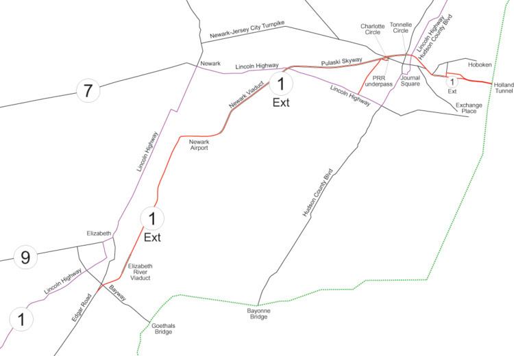
- Map of Pulaski Skyway New Jersey USA
- Routes 1 and 2 1916 1927
- Route 1 Extension 1922 1932
- Construction
- Route 25 1927 1953
- References
Map of Pulaski Skyway, New Jersey, USA
Route 1 largely became Route 25 in the 1927 renumbering. Route 25 was best known for the 13-mile (21 km) Route 1 Extension, which became the first controlled-access highway or "super-highway" in the United States that also connected the high traffic volume from the Holland Tunnel to the rest of New Jersey (with roads to other state destinations). The Holland Tunnel was the first vehicular connection between New York City and New Jersey that were separated by the Hudson River.
Route 1 Extension was built between 1925 - 1932 and was best known for the Pulaski Skyway. The Pulaski Skyway and portions of the currently designated Route 139 have been listed on the federal and NJ state registers of historic places since 2005 as part of a nominated portion of the Route 1 Extension.
Routes 1 and 2: 1916-1927
In 1916, two routes were defined by the state legislature:
Route 1 used the existing Lincoln Highway from Elizabeth to New Brunswick, except for two sections between Rahway and New Brunswick (where the Lincoln Highway largely used the old Essex and Middlesex Turnpike). A new alignment was built on the northwest side of the Pennsylvania Railroad (now Amtrak's Northeast Corridor) in Woodbridge Township and Edison to avoid two grade crossings, and a detour around existing streets was made in Metuchen to avoid another one in favor of a tunnel. This route, including the realignments, was taken over in 1919, except between the south border of Rahway and downtown Metuchen, which was acquired in 1918.
South of New Brunswick, Route 1 used the old New Brunswick and Cranbury Turnpike (Georges Road) to Cranbury and the Bordentown and South Amboy Turnpike to Robbinsville. At Robbinsville, it turned west on Nottingham Way, running to the Trenton line on Greenwood Avenue. This section was all taken over in 1919.
Route 2 left Trenton on Broad Street, known as the White Horse Road, to White Horse. At White Horse it turned south on what was known as the White Horse Road Extension and Trenton Road, intersecting the Bordentown and South Amboy Turnpike northeast of Bordentown. There it turned southwest along the turnpike, named Park Street in Bordentown, continuing on the Florence Road (old Burlington Turnpike) through Florence Township to Burlington. From Burlington, Route 2 kept going southwest on the Westfield and Camden Turnpike, ending at the Camden border at Westfield Avenue. This was also taken over in 1919.
Several amendments in 1922 added to the routes. Route 2 was extended southwest through Camden to the proposed Ben Franklin Bridge, and a spur was added from Five Points northwest to the Tacony-Palmyra Ferry. More important was the extension of Route 1 north to the planned Holland Tunnel.
Route 1 Extension: 1922-1932
The 13-mile (21 km) Route 1 Extension is considered to be the first controlled-access highway or "super-highway" in the United States. The highway was built to carry large amounts of traffic from the Holland Tunnel to the rest of New Jersey. The south end of the extension was at Edgar Road in Linden, just south of Elizabeth and the Bayway Circle. Edgar Road had been built as a turnpike in the 19th century, and now serves as part of U.S. Route 1/9 south of the extension.
The road was built from 1925 to 1932. All, but the Pulaski Skyway, was finished by 1930. It was a full freeway, mostly elevated on embankments or viaducts, from four blocks west of the Holland Tunnel to just north of Newark Airport, and a high-speed surface road from there to Elizabeth (and beyond).
In summer of 1923, the NJ State Highway Commission decided that it would be an entirely new route, from the Lincoln Highway (Route 1) southwest of Elizabeth to the Holland Tunnel. Existing roads, which passed through downtown Newark, were already experiencing major congestion. Frederick Lavis, Assistant Construction Engineer of the New Jersey State Highway Department, explained this decision:
The new highway will be the easterly end of the Lincoln Highway and will carry the greater part of the travel between New Jersey coast resorts, and Trenton, Philadelphia and points south of New York. It was to be made part of one of the main through routes from and to New York. It was stated that this route would undoubtedly be used as a main artery of transportation by trucks carrying freight from New Jersey, Pennsylvania and adjacent points to and from New York.It was reported that the highway will assume many of the characteristics of a railway, except that the rolling stock will be autos and auto trucks. It was pointed out that in order that the maximum amount of traffic could pass, the highway would have to be free from interruption.It was also decided that the road would have a minimum width of 50 feet (15 m), which would be enough room for five lanes. The center one was intended as a vehicle breakdown lane since there were no shoulders, but was used as a "suicide lane" for passing slower traffic. At the time, it often took two or three hours to go the 15 miles (24 km) from New York City to the far border of Elizabeth, and the new highway would reduce travel time by over an hour. Grades would be at most 3.5%, and roadway curves would have radii of at least 1,000 feet (300 m).
Construction
As part of the Holland Tunnel project, the New Jersey Interstate Bridge and Tunnel Commission and the New York State Bridge and Tunnel Commission widened the four blocks of 12th and 14th Streets in Jersey City from Jersey Avenue to Provost Street. 12th Street was widened west of Grove Street to 100 feet (30 m), with the remaining block, at the toll plaza, being 160 feet (49 m) wide. 14th Street, and the two blocks of Jersey Avenue carrying westbound traffic to the 12th Street Viaduct, were widened to 100 feet (30 m).
As part of the project, current U.S. Route 1-9 Truck was built under the Pennsylvania Railroad at Charlotte Circle and east to Tonnele Circle. This was bypassed by the Pulaski Skyway, the last part of the route to be built. Prior to its completion, traffic used what is now US 1-9 Truck.
The city of Elizabeth opposed the alignment along Spring Street, preferring the use of Division Street, but lost the argument.
Route 25: 1927-1953
Route 1 largely became Route 25 in the 1927 renumbering and Route 1 again in the 1953 highway renumbering in New Jersey.
In the 1927 renumbering, the majority of the Jersey City-Camden corridor, made of Routes 1 and 2, was assigned Route 25. The one major difference was near Trenton; the new Route 25 bypassed Trenton via the old Bordentown and South Amboy Turnpike, cutting from Route 1 at Robbinsville southwest to Route 2 at Bordentown. Route 1 west from Robbinsville to Trenton became part of Route 33, and Route 2 became part of Route 37 from Trenton to White Horse and Route 39 from White Horse to Bordentown. Additionally, the former Route 1 between Elizabeth and New Brunswick became part of Route 27; a new alignment was planned from Elizabeth to south of New Brunswick, running east of the existing road and connecting directly with the Route 1 Extension. The short spur to the Tacony-Palmyra Ferry became Route S41N.
Also in 1927, U.S. Route 1 was assigned to Route 25 north of the New Brunswick area (temporarily signed along Route 27 until Route 25 was finished) and U.S. Route 130 was assigned south to Camden.
North of New Brunswick, the new 50-foot (15 m) wide alignment was completed September 27, 1930; the last part to open was the reconstruction of Edgar Road through Linden, held up by a grade crossing elimination with the Baltimore and New York Railroad. The part of old Route 1 to the south border of New Brunswick became Route 25M. The Pulaski Skyway opened in 1932. Sources disagree about whether the old route (U.S. Route 1-9 Truck) became another Route 25M, Route 25T, or an un-suffixed section of 25. (The eastern half of the old road was part of post-1927 New Jersey Route 1.)
The embankment in Newark was doubled in 1949 with a new four-lane northbound roadway.
The Port of New York Authority, which superseded the two state tunnel commissions and took over authority for the Holland Tunnel, built the 14th Street Viaduct in order to avoid the turns to and from Jersey Avenue, but turned over authority over the viaduct to the New Jersey State Highway Commission. The four-lane, westbound 1,800-foot (550 m) viaduct, which was connected to the 12th Street Viaduct, was opened on February 13, 1951.
Many bypasses were built south of New Brunswick:
In the 1953 renumbering, the whole route was decommissioned in favor of the U.S. Routes that were signed along it - US 30, US 130, US 1 and US 1 Business.