
Named for Thomas Nelson, Jr. Area 1,228 km² Population 14,789 (2013) | Founded 1807 | |
 | ||
Website www.nelsoncounty-va.gov Points of interest Destinations George Washington and Jeffer, Wintergreen - Virginia, Afton, Schuyler, Arrington - Virginia | ||
Live where you love nelson county virginia
Nelson County is a county located in the Commonwealth of Virginia. As of the 2010 census, the population was 15,020. Its county seat is Lovingston.
Contents
- Live where you love nelson county virginia
- Map of Nelson County VA USA
- Hiking crabtree falls near montebello nelson county virginia
- History
- Hurricane Camille
- Geography
- Adjacent counties
- National protected areas
- Major highways
- Education
- Demographics
- Recreation
- Communities
- Census designated places
- Notable people
- References
Map of Nelson County, VA, USA
Nelson County is part of the Charlottesville, VA Metropolitan Statistical Area.
Nelson County is home to Wintergreen Resort, a local ski area; Swannanoa mansion and is the location of Walton's Mountain made famous by the television show, The Waltons. Nelson County is also home to ten wineries, five craft breweries, two cideries, two distilleries, many fruit orchards and Crabtree Falls.
Hiking crabtree falls near montebello nelson county virginia
History
At the time the English began settling Virginia in the 1600s, the inhabitants of what is now Nelson County were a Siouan-speaking tribe called the Nahyssan. They were probably connected to the Manahoac.
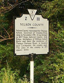
Nelson County was created in 1807 from Amherst County. The government was formed the following year. The county is named for Thomas Nelson, Jr., a signer of the U.S. Declaration of Independence, who served as Governor of Virginia in 1781. An earlier Virginia county, also named in his honor, became part of Kentucky when it separated from Virginia in 1792.
Hurricane Camille
On the night of August 19–20, 1969, Nelson County was struck by disastrous flooding caused by Hurricane Camille. The hurricane hit the Gulf Coast two days earlier, weakened over land, and stalled on the eastern side of the Blue Ridge Mountains, dumping a world record quantity of 27 inches (690 mm) of rain, mainly in a three-hour period. Over five hours, it yielded more than 37 inches (940 mm), while the previous day had seen a deluge of 5 inches (130 mm) in half an hour, with the ground already saturated. There were reports of animals drowning in trees and people who had had to cup their hands around their mouth and nose to breathe.
Flash floods and mudslides killed 153 people, 31 from Roseland, Tyro, and Massies Mill alone. Over 133 public bridges were washed out in Nelson County, while some communities were under water. In the tiny community of Davis Creek, 52 people were killed or could not be found; only 3 of 35 homes were left standing after the floodwaters receded. The bodies of some people have never been found; others washed as much as 25 miles (40 km) downstream along the creeks and rivers. The entire county was virtually cut off, with many roads and virtually all bridges, telephone, radio/TV, and electric service interrupted.
The waters of the Tye, Piney, Buffalo, and Rockfish rivers flow into the James River. There was massive flooding elsewhere in Virginia, such as along the Maury River, which destroyed the town of Glasgow in Rockbridge County.
The James River and its tributaries normally drain Nelson County, but in the face of massive flooding from other tributaries such as Hatt Creek (along the James River some 80 miles (130 km) to the east) the James River crested more than 20 feet (6.1 m) above flood stage at Westham, as Nelson County citizens watched portions of houses and other buildings, bodies, and dead livestock flow past. Just a few miles further downstream, the James River crested at the City Locks in Richmond at 28.6 feet (8.7 m) swamping downtown areas and also flooding a substantial portion of South Richmond (formerly the separate city of Manchester.). The Hurricane Camille disaster did over $140 million (in 1969 dollars) in damage across Virginia, however in no other place in Virginia was the storm as devastating and deadly as in Nelson County, where one percent of the population was killed and where many bodies were never recovered.
Geography
According to the U.S. Census Bureau, the county has a total area of 474 square miles (1,230 km2), of which 471 square miles (1,220 km2) is land and 3.5 square miles (9.1 km2) (0.7%) is water. The Blue Ridge Mountains form the northwest boundary of the county; the James River forms the boundary to the southeast. Internally, Nelson consists of the Rockfish, Tye and Piney rivers, along with many known creeks.
Adjacent counties
National protected areas
Major highways
Education
Nelson County Public Schools is a Virginia public school division. It operates two elementary schools, one middle school, and one high school. The middle and high schools are connected and located just outside Lovingston, Virginia. Nelson County also provides free GED testing to all adults.
Jefferson-Madison Regional Library is the regional library system that provides services to the citizens of Nelson.
Demographics
As of the census of 2010, there were 15,020 people, 6,396 households, and 4,302 families residing in the county. The population density was 31.9 people per square mile (12/km²). There were 8,554 housing units at an average density of 18 per square mile (7/km²). The racial makeup of the county was 83.3% White or European American, 13.1% Black or African American, 0.3% Native American, 0.5% Asian, Z% Pacific Islander, 1.1% from other races, and 1.7% from two or more races. 3.1% of the population were Hispanic or Latino of any race.
There were 6,396 households, out of which 21.6% had children under the age of 18 living with them, 51.6% were married couples living together, 11.1% had a female householder with no husband present, and 32.7% were non-families. 27.4% of all households were made up of individuals and 11.1% had someone living alone who was 65 years of age or older. The average household size was 2.33 and the average family size was 2.81.
In the county, the population was spread out with 19.3% under the age of 18, 5.7% from 18 to 24, 25.5% from 25 to 44, 29.60% from 45 to 64, and 19.9% who were 65 years of age or older. The median age was 42.8 years. For every 100 females there were 95.2 males. For every 100 females age 18 and over, there were 93 males.
The median income for a household in the county was $48,118, and the median income for a family was $57,356. Males had a median income of $45,222 versus $34,842 for females. The per capita income for the county was $26,996. 11.9% of the population and 8.9% of families were below the poverty line. Out of the total people living in poverty, 13.8% are under the age of 18 and 9.5% are 65 or older.
Recreation
The Wintergreen Resort near Nellysford opened in 1975. A planned development begun in 1969, it offers 45 holes of championship golf; seasonal skiing, snowboarding and snowtubing. On the eastern slope of the Blue Ridge, Wintergreen is a "top down" resort in which practically all of the amenities are built on the peaks and ridges, rather than at the base like a traditional ski resort.
Sections of the former Virginia Blue Ridge Railway along the Tye River are now part of the Blue Ridge Railway Trail, which was under development in the early 21st century. The trail will eventually connect the James River with the Blue Ridge Parkway and the Appalachian Trail.
Fishing and camping are popular activities in Nelson County. Sections of the Tye River are also popular for whitewater boating with canoes and kayaks. The rapids are rated Class I to Class II+. Depending upon water conditions some rapids on the Tye River can approach class III.
The first annual Lockn' Music Festival was held September 5–8, 2013 on a farm in Nelson County near Arrington, Virginia.
Camp Jeep was held at the Oak Ridge Estate in Arrington for several years beginning in 1999 with the last event taking place in 2007.
Communities
There are no cities or incorporated towns in Nelson County. Unincorporated communities include: