
First ascent unclimbed | Elevation 370 m | |
 | ||
Location | ||
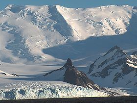
Needle Peak is a sharply pointed black peak, 370 m, standing at the west side of Brunow Bay on the south coast of Livingston Island in the South Shetland Islands. Situated in the southeast foothills of Friesland Ridge, Tangra Mountains on Rozhen Peninsula, 1 km south-southeast of Ludogorie Peak, and surmounting Prespa Glacier to the west, Samuel Point to the east by south, and Brunow Bay to the northeast.
Contents
Map of Needle Peak, Antarctica
The feature was named ‘Barnards Peak’ on James Weddell's chart published in 1825, but the name ‘Needle Peak’ given by Discovery Investigations personnel following a 1935 survey has succeeded it in usage. The name Barnard Point has been approved for the nearby point at the southeast side of False Bay.
Maps
References
Needle Peak (Livingston Island) Wikipedia(Text) CC BY-SA