
Length 134.5 km | ||
 | ||
Major cities | ||
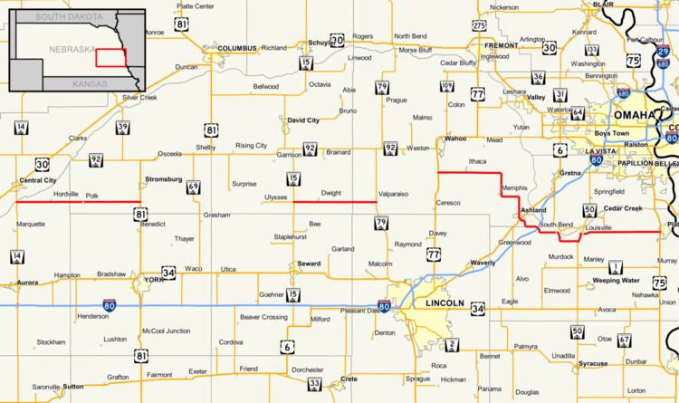
Nebraska Highway 66 is a highway in central and eastern Nebraska. It is a discontinuous highway with four segments heading in a west-to-east direction. The first segment begins at Nebraska Highway 14 south of Central City and ends at U.S. Highway 81 south of Stromsburg. The second segment begins at Nebraska Highway 15 west of Dwight and ends at Nebraska Highway 79 in Valparaiso. The third segment begins at U.S. Highway 77 south of Wahoo and ends at Main Street in Louisville. The fourth and final segment begins at the intersection with Walnut Street and Koop Avenue in Louisville, and ends at U.S. Highway 34 and U.S. Highway 75 west of Plattsmouth.
Contents
First segment
Nebraska Highway 66 begins at an intersection with NE 14 south of Central City. It heads eastward through farmland, passing through Hordville and Polk along the way. South of Stromsburg, it meets US 81 where the segment terminates. The next segment begins about 26 miles (42 km) to the east of this point.
Second segment
The second segment of Nebraska Highway 66 begins at NE 15 west of Dwight. It continues in an eastward direction through farmland before ending at NE 79 in Valparaiso. The next segment picks up just over 15 miles (24 km) to the east of Valparaiso.
Third segment
The third segment of NE 66 starts at an intersection with US 77 south of Wahoo. It again continues eastward and to the southeast into farmland, passing near the communities of Ithaca and Memphis. To the southeast, it enters Ashland where the highway will intersect with US 6. Continuing to the southeast, NE 66 intersects I-80 at exit 426. The highway continues eastward, passing through South Bend and heading to the southeast. Southwest of Louisville, the route intersects with NE 50 and runs concurrently northward with it for just over a mile. Upon entering Louisville, NE 66 splits off to the east. At Main Street in Louisville, this segment ends only to resume 0.13 miles (0.21 km) to the east.
Fourth segment
Still in Louisville, the final segment of NE 66 starts at the intersection with Koop Avenue and Walnut Street. It continues eastward, exiting Louisville and entering farmland. Further to the east, the highway intersects with US 34 and US 75 just west of Plattsmouth. At this point, the segment terminates and the highway ends.
History
Prior to October 24, 2005, the segment of Nebraska Highway 66 between U.S. Highway 77 south of Wahoo and U.S. Highway 6 in Ashland was designated as Nebraska Highway 63. On that day, this segment was renumbered to the present designation of NE 66.