
Source elevation 85 m | Length 60 km | |
 | ||
Basin size 108 square miles (280 km) Discharge Average rate:150 cu ft/s (4.2 m/s) | ||
The Nashua River, 37.5 miles (60.4 km) long, is a tributary of the Merrimack River in Massachusetts and New Hampshire in the United States. It is formed in eastern Worcester County, Massachusetts, by junction of its north and south branches near Lancaster, and flows generally north-northeast past Groton to join the Merrimack at Nashua, New Hampshire. The Nashua River Watershed occupies a major portion of north-central Massachusetts and a much smaller portion of southern New Hampshire.
Contents
Map of Nashua River, United States
The north branch rises west of Fitchburg and Westminster. It flows about 30 miles (48 km) generally southeast past Fitchburg, and joins the south branch about 5 miles (8.0 km) below its issuance from the Wachusett Reservoir.
HistoryEdit
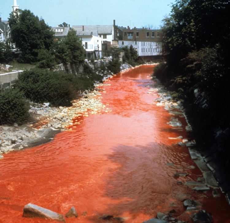
The Nashua River was heavily used for industry during the colonial period and the early United States. During the late 18th century and early 19th century, the heavy concentration of paper mills and the use of dyes near Fitchburg resulted in pollution that notoriously turned the river various colors downstream from the factories.
In the mid-1960s, Marion Stoddart started a campaign to restore the Nashua River and its tributaries. She built coalitions with labor leaders and business leaders, in particular the paper companies who were the worst polluters of the river. With federal help, eight treatment plants were built or upgraded along the river. A broad conservation buffer was created along about half the river and its two main tributaries. By the early-1990s, most of the industry was still located along the river, but many parts of the river were once again safe for swimming. Her work is the subject of a 30-minute documentary movie.
Recovery has sparked recreational use of the river at places like Mine Falls Park in Nashua.
The largely volunteer Nashua River Watershed Association, based in Groton, Massachusetts, oversees the condition of the river.
On January 23, 2013, Rep. Niki Tsongas introduced the Nashua River Wild and Scenic River Study Act (H.R. 412; 113th Congress), a bill that would amend the Wild and Scenic Rivers Act to designate certain segments concerning the Nashua River for study for potential addition to the National Wild and Scenic Rivers System.
WatershedEdit
From its impoundment at the Wachusett Reservoir in Clinton, Massachusetts, the South Branch of the Nashua River flows north and joins the North Branch of the Nashua River in Lancaster, Massachusetts. The North Branch of the Nashua River flows southeast from Fitchburg and Leominster, Massachusetts, to Lancaster. The Nashua River flows northward from Lancaster, meandering its way through the north-central Massachusetts towns of Harvard, Groton, Dunstable, and Pepperell, before eventually emptying into the Merrimack River at Nashua, New Hampshire. The Nashua River Watershed has a total drainage area of approximately 538 square miles (1,390 km2), with 454 square miles (1,180 km2) of the watershed occurring in Massachusetts and 74 square miles (190 km2) in New Hampshire. The Nashua River flows for approximately 56 miles (90 km), with approximately 46 of those miles (74 km) flowing through Massachusetts. The Squannacook, Nissitissit, Stillwater, Quinapoxet, North Nashua, and South Nashua rivers feed it. The watershed encompasses all or part of 31 communities, 7 in southern New Hampshire and 24 in central Massachusetts. The watershed’s largest water body is the Wachusett Reservoir, which provides drinking water to two-thirds of the Commonwealth's population.