
Country United States County Worcester Incorporated 1759 Elevation 329 m Population 7,277 (2010) | Settled 1737 Time zone Eastern (UTC-5) Zip code 01473 Local time Saturday 8:12 AM | |
 | ||
Weather 0°C, Wind N at 23 km/h, 97% Humidity | ||
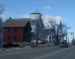
Community tour of westminster massachusetts
Westminster is a town in Worcester County, Massachusetts, in the United States. At the 2010 census, the town population was 7,277.
Contents
- Community tour of westminster massachusetts
- Map of Westminster MA USA
- History
- Geography
- Demographics
- Transportation
- Education
- Library
- Business
- Notable people
- References
Map of Westminster, MA, USA
History
Westminster was first settled in 1737, and was officially incorporated in 1759.
Westminster has four entries in the National Register of Historic Places:
The District includes the following buildings:
Westminster was the site of Westminster Academy, incorporated in 1833.
The town achieved national news in November 2014 when the Board of Health proposed banning all sales of tobacco. The meeting between the Board of Health and concerned citizens did not go well with citizens raising objections to the governmental over-reach.
Geography
According to the United States Census Bureau, the town has a total area of 37.3 square miles (97 km2), of which 35.5 square miles (92 km2) is land and 1.8 square miles (4.7 km2), or 4.90%, is water.
Westminster is bordered by Ashburnham to the north, Gardner to the west, Hubbardston to the southwest, Princeton to the south, and Leominster and Fitchburg to the east.
Demographics
As of the census of 2000, there were 6,907 people, 2,529 households, and 1,954 families residing in the town. The population density was 194.5 people per square mile (75.1/km²). There were 2,694 housing units at an average density of 75.9 per square mile (29.3/km²). The racial makeup of the town was 97.50% White, 0.46% African American, 0.14% Native American, 1.14% Asian, 0.14% from other races, and 0.61% from two or more races. Hispanic or Latino of any race were 1.11% of the population. 17.6% were of French, 15.0% Irish, 13.2% French Canadian, 9.0% English, 9.0% Italian, 8.5% Finnish and 5.6% American ancestry according to Census 2000.
There were 2,529 households out of which 36.9% had children under the age of 18 living with them, 65.8% were married couples living together, 8.1% had a female householder with no husband present, and 22.7% were non-families. 17.7% of all households were made up of individuals and 6.6% had someone living alone who was 65 years of age or older. The average household size was 2.73 and the average family size was 3.09.
In the town, the population was spread out with 26.8% under the age of 18, 6.1% from 18 to 24, 28.9% from 25 to 44, 27.3% from 45 to 64, and 10.9% who were 65 years of age or older. The median age was 39 years. For every 100 females there were 99.5 males. For every 100 females age 18 and over, there were 95.4 males.
The median income for a household in the town was $57,755, and the median income for a family was $61,835. Males had a median income of $45,369 versus $31,818 for females. The per capita income for the town was $24,913. About 3.0% of families and 3.1% of the population were below the poverty line, including 1.5% of those under age 18 and 5.1% of those age 65 or over.
Transportation
Public transportation for northern Worcester county is largely supplied by the Montachusett Regional Transit Authority (MART) fixed-route bus system. Wachusett station, located in Westminster, is the western terminus of the MBTA Commuter Rail Fitchburg Line.
Education
Westminster is part of the Ashburnham-Westminster Regional School District.
Two elementary schools and one middle school are located in Westminster. The Meetinghouse School serves students in grades K-1; the Westminster Elementary School, grades 2-5; and the Overlook Middle School, grades 6-8.
Oakmont Regional High School (traditional public high school) in Ashburnham/Westminster, MA and Montachusett Regional Vocational Technical School (vocational/technical high school) in Fitchburg, MA are the two public high schools serving the town of Westminster.
Library
The Westminster Town Library was established in 1868. In fiscal year 2008, the town of Westminster spent 2.97% ($518,171) of its budget on its public library—some $70 per person.
Business
From 1828 to 1970, Westminster was home to the Westminster Cracker Company. Westminster is currently home to: