
Country United States Incorporated February 14, 1871 Elevation 69 m Zip code 01432 Local time Friday 1:52 PM | State Massachusetts Settled 1668 Time zone Eastern (UTC-5) Founded 14 February 1871 Population 7,427 (2010) | |
 | ||
Weather 2°C, Wind NW at 14 km/h, 19% Humidity Area 24.86 km² (23.31 km² Land / 155 ha Water) | ||
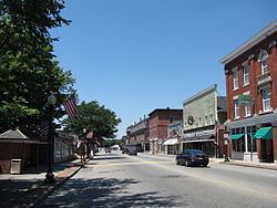
Ayer is a town in Middlesex County, Massachusetts, United States. Originally part of Groton, it was incorporated February 14, 1871 and became a major commercial railroad junction. The town was home to Camp Stevens, a training camp for Massachusetts volunteers during the American Civil War. Later, Fort Devens was established by the federal government to train New England soldiers for World War I. Fort Devens is a major influence on the area, although it is considerably smaller than when it was first closed in the mid-1990s. The town's population was 7,427 at the 2010 census.
Contents
- Map of Ayer MA USA
- Founding
- Regional rail hub
- Military roles
- Ski jump
- Modern day
- Geography
- Demographics
- Government
- Education
- Transportation
- Points of interest
- Notable residents
- References
Map of Ayer, MA, USA
For geographic and demographic information on specific parts of the town of Ayer, please see the articles on Ayer (CDP) and Devens, Massachusetts.
Founding
Ayer's history dates back to 1667, when the first mill in the agricultural community was built. The settlement sits on what the Nipmuc Indians called Nainacocius. A brook remains with that name. Originally part of Groton, the community was initially called Groton Junction or South Groton. The town of Ayer was incorporated in 1871, and was named in honor of Dr. James Cook Ayer, a prominent resident of Lowell who provided the funding for the construction of the Town Hall.
Regional rail hub
The town's growth was influenced by a period of rapid development of railroad transportation. Though only 9.5 square miles (25 km2) in area, the town became a major junction for both east-west and north-south rail lines, and developed into an important commercial center oriented towards the rail industry. Known as Groton Junction and later Ayer Junction, the intersecting railroads included:
The split between the Stony Brook and Fitchburg main line was moved east from the central junction to reduce parallel trackage.
Military roles
During the Civil War an army training camp, Camp Stevens, was located near the Nashua River. Camp Devens, which eventually became Fort Devens, was established in 1917, during World War I. The presence of thousands of military and civilian personnel on the base shifted Ayer's commercial development towards meeting their needs until Fort Devens was closed in 1996, but was reopened the next day as a reserve training area. It has since been reopened, although on a much smaller scale then the days when it was active.
Ski jump
In 1935, the largest Nordic ski jump in North America was constructed at Pingry Hill near the Willows. A 700-foot-high wooden trestle build, the ski jump operated for a single winter season amid the hardships of Great Depression-era Ayer. Part of the structure was blown down by the wind in the summer of 1936 and it was never rebuilt. Some of the lumber was salvaged by local residents over the next few years. As of 2013, no trace of the massive structure remains.
Modern day
Within its relatively small area Ayer boasts numerous industries, including plants belonging to Cains, Vitasoy and Pepsi, a historical downtown unique to the region, and modern commuter rail service to Boston.
The Hollywood film Conviction (2010 film) depicted the legal drama surrounding the investigation, conviction and eventual exoneration of Kenneth "Kenny" Waters, for the 1980 murder of Katharina Brow. Waters' sister Betty Anne worked with the Innocence Project, a nonprofit organization devoted to overturn the wrongful convictions using DNA test results as evidence. In 2009 the town and its insurers eventually paid a $3.4 million settlement in response to a civil rights lawsuit by the estate of Kenneth Waters.
Geography
According to the United States Census Bureau, the town has a total area of 9.6 square miles (24.8 km2), of which 9.0 square miles (23.4 km2) is land and 0.6 square mile (1.4 km2) (5.75%) is water.
Ayer borders the following towns: Shirley, Groton, Littleton, and Harvard.
Demographics
At the 2010 census, there were 7,427 people, 3,118 households and 1,831 families residing in the town. The population density was 825.2 per square mile (317.4/km2). There were 3,462 housing units at an average density of 384.7 per square mile (147.9/km2). The racial makeup of the town was 84.3% White, 5.9% African American, 0.3% Native American, 3.6% Asian, 2.3% from other races, and 3.4% from two or more races. Hispanic or Latino of any race were 5.7% of the population.
There were 3,063 households of which 26.5% had children under the age of 18 living with them, 46.0% were married couples living together, 2.8% had a male householder with no wife present, 11.9% had a female householder with no husband present, and 39.3% were non-families. 32.4% of all households were made up of individuals and 10.7% had someone living alone who was 65 years of age or older. The average household size was 2.26 and the average family size was 2.86.
Of the 7,427 people in the population, 22.6% were under the age of 18, 7.5% were 15 to 19 years of age, 6.7% were 20 to 24 years of age, 28.1% were 25 to 44 years of age, 28.1% were 45 to 64 years of age, and 11.4% were 65 years and over. The median age was 38.2 years. For every 100 females there was 101.2 males. For every 100 females 18 years and over there were 97.9 males.
The median household income was $54,899, and the median family income was $78,947. The median income of individuals working full time was $53,194, for males versus $47,198 for females. The per capita income for the town was $32,179. About 8.0% of families and 12.8% of the population were below the poverty line, including 12.5% of those under age 18 and 9.9% of those age 65 or over.
Government
As a New England town, Ayer is governed by town meeting and a three-member board of selectmen.
Education
Private schools serving Ayer include:
Transportation
Montachusett Regional Transit Authority (MART) supplies Councils-On-Aging service. Commuter rail service from Boston's North Station is provided by the MBTA with a stop in Ayer on its Fitchburg Line.
Freight travels daily through Ayer over the tracks of the historic Stony Brook Railroad. The line currently serves as a major corridor of Pan Am Railway's District 3 which connects New Hampshire and Maine with western Massachusetts, Vermont, and New York.
The southern segment of the Nashua River Rail Trail commences in Ayer.
Points of interest
Places on the National Register of Historic Places: